Haunted Mine Falls at Tioga State Forest near Wellsboro, Pennsylvania is an easy 0.1-mile out-and-back bushwhack hike that leads to Tioga County's largest waterfall, which cascades down the mountain at about 400-feet tall in total with a visible 50 vertical feet.
Haunted Mine Falls Height (400-feet total, 50-feet visible)
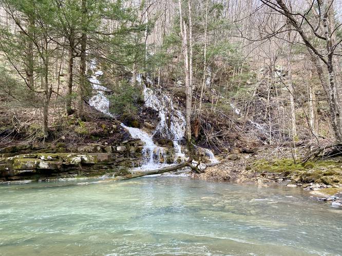
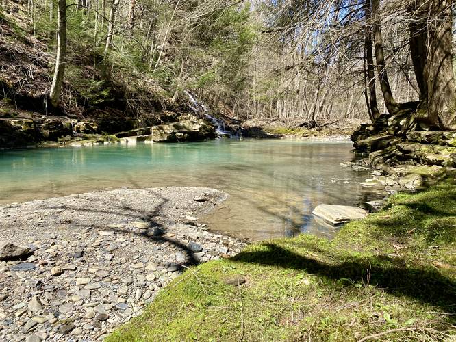
Haunted Mine Falls is Tioga County's largest waterfall at approximately 400-feet tall in total. The waterfall cascades down the mountainside from near the top of the mountain, located around ~1,600-feet above sea level to ~1,200-feet above sea level at Wilson Creek, hence the entire height being approximately ~400-feet tall. Note that this waterfall is essentially a massive mountainside creek that tumbles down the mountain in a continuous stream with very few flat sections along the way. At the base of Haunted Mine Falls, where this hike stops, hikers can view approximately 50 vertical feet of the waterfall, with some small glimpses of the upper cascades when the leaves are off of the trees.
Hike Description
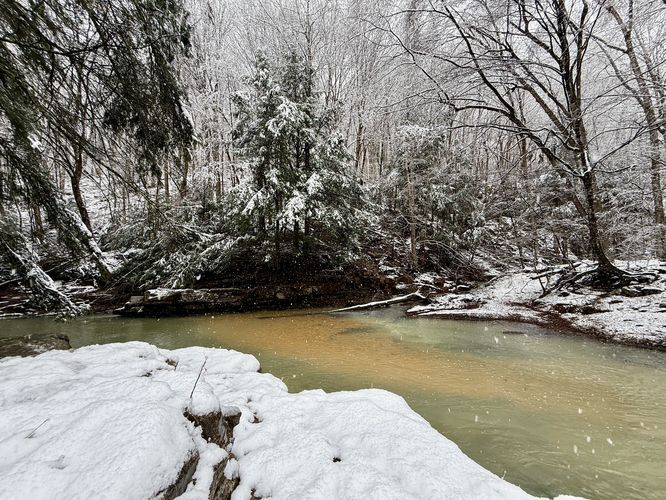
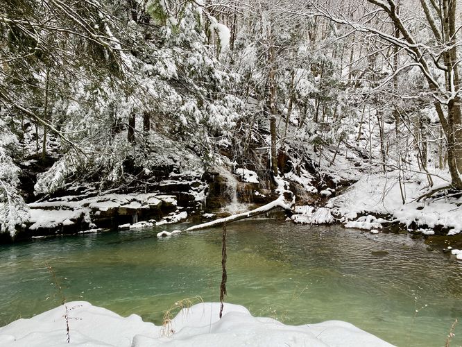
This hike, rather short woods walk, begins along the western side of PA-287 at the coordinates provided near the Wilson Creek underpass. Hikers will head into the woods, passing through overgrowth (during warm months), small trees, and a power line to reach Wilson Creek. Just upstream, impossible to miss, is the 50-foot base of Haunted Mine Falls as it spills into a beautiful fishing hole in Wilson Creek.
Haunted Mile Falls - Mile 0.1
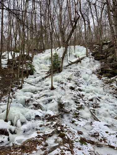
Around mile 0.1, hikers will reach the base of Haunted Mine Falls. This visible portion of Haunted Mine Falls cascades into Wilson Creek at about 50 vertical feet; however, the waterfall itself does not have any free-falling cascades and tumbles down the mountain at about 400 vertical feet in total. Haunted Mine Falls is split into several waterfalls that spill down the mountainside, with about three of these cascades falling into a similar location. Some cascades re-route north-slightly, which appears to have some free-falling cascades, but require wading through the deeper Wilson Creek to reach a good view of that section. During the winter, the northern section appears to freeze over into large ice blocks. During the early Spring, you may be able to spot some of these slowly-melting frozen waterfalls.
Haunted Mine Falls Name
This waterfall gets it name from the nearby Haunted Vista, which is named after the Anna S. Mine which is located at the top of the mountain. The Anna S. Mine was in operation from 1905 - 1937 and was built by the Fall Brook Coal Company. The mine used the bucket tram to move coal across the Wilson Creek valley below and over to the mountains on the east side of the valley. Once the coal was on the eastern side of Wilson Creek valley, it would be transported by the New York Central railroad in Antrim, PA. Folklore claims that some miners would ride the buckets across the valley. One story claims that one miner road the buckets during the winter, but the tram was turned off and the miner froze to death hanging hundreds of feet above the mountain valley. Most of these stories were never proven or were disputed to not be plausible, but are still interesting to think about. Other stories depict miners who perished in the Anna S. Mine.
Waterfall's Ghostly-White Color
The white water cascading down Haunted Mine Falls is treated with a special material to lower the acidity levels in the water, as all of this water is essentially acid mine run-off. The massive human-made pools at the top of the mountain treat the water before it sends it down into Wilson Creek, causing the water to appear a ghostly-white. I believe the substance used to treat the water is calcitic limestone.
Parking
Hikers can park off the road on PA-287 near the coordinates provided on the west side of the road; however, please be careful when walking near or around the highway as cars travel about 55+ MPH here.
Pets
Dogs are allowed if leashed and cleaned up after.
Warning
Highway traffic: Again, parking here can be kind of sketchy as there are no real parking turnouts. Cars can easily fit off-road to park on the grass or partially on pavement. Watch the traffic.
Haunted Mine Falls Height (400-feet total, 50-feet visible)
Haunted Mine Falls is Tioga County's largest waterfall at approximately 400-feet tall in total. The waterfall cascades down the mountainside from near the top of the mountain, located around ~1,600-feet above sea level to ~1,200-feet above sea level at Wilson Creek, hence the entire height being approximately ~400-feet tall. Note that this waterfall is essentially a massive mountainside creek that tumbles down the mountain in a continuous stream with very few flat sections along the way. At the base of Haunted Mine Falls, where this hike stops, hikers can view approximately 50 vertical feet of the waterfall, with some small glimpses of the upper cascades when the leaves are off of the trees.
Hike Description
This hike, rather short woods walk, begins along the western side of PA-287 at the coordinates provided near the Wilson Creek underpass. Hikers will head into the woods, passing through overgrowth (during warm months), small trees, and a power line to reach Wilson Creek. Just upstream, impossible to miss, is the 50-foot base of Haunted Mine Falls as it spills into a beautiful fishing hole in Wilson Creek.
Haunted Mile Falls - Mile 0.1
Around mile 0.1, hikers will reach the base of Haunted Mine Falls. This visible portion of Haunted Mine Falls cascades into Wilson Creek at about 50 vertical feet; however, the waterfall itself does not have any free-falling cascades and tumbles down the mountain at about 400 vertical feet in total. Haunted Mine Falls is split into several waterfalls that spill down the mountainside, with about three of these cascades falling into a similar location. Some cascades re-route north-slightly, which appears to have some free-falling cascades, but require wading through the deeper Wilson Creek to reach a good view of that section. During the winter, the northern section appears to freeze over into large ice blocks. During the early Spring, you may be able to spot some of these slowly-melting frozen waterfalls.
Haunted Mine Falls Name
This waterfall gets it name from the nearby Haunted Vista, which is named after the Anna S. Mine which is located at the top of the mountain. The Anna S. Mine was in operation from 1905 - 1937 and was built by the Fall Brook Coal Company. The mine used the bucket tram to move coal across the Wilson Creek valley below and over to the mountains on the east side of the valley. Once the coal was on the eastern side of Wilson Creek valley, it would be transported by the New York Central railroad in Antrim, PA. Folklore claims that some miners would ride the buckets across the valley. One story claims that one miner road the buckets during the winter, but the tram was turned off and the miner froze to death hanging hundreds of feet above the mountain valley. Most of these stories were never proven or were disputed to not be plausible, but are still interesting to think about. Other stories depict miners who perished in the Anna S. Mine.
Waterfall's Ghostly-White Color
The white water cascading down Haunted Mine Falls is treated with a special material to lower the acidity levels in the water, as all of this water is essentially acid mine run-off. The massive human-made pools at the top of the mountain treat the water before it sends it down into Wilson Creek, causing the water to appear a ghostly-white. I believe the substance used to treat the water is calcitic limestone.
Parking
Hikers can park off the road on PA-287 near the coordinates provided on the west side of the road; however, please be careful when walking near or around the highway as cars travel about 55+ MPH here.
Pets
Dogs are allowed if leashed and cleaned up after.
Warning
Highway traffic: Again, parking here can be kind of sketchy as there are no real parking turnouts. Cars can easily fit off-road to park on the grass or partially on pavement. Watch the traffic.