Loading...

WINTER SALE! 50% OFF Supporter Accounts — now through January 31st. Learn More.

Hanging Rock Overlook

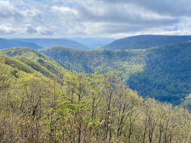
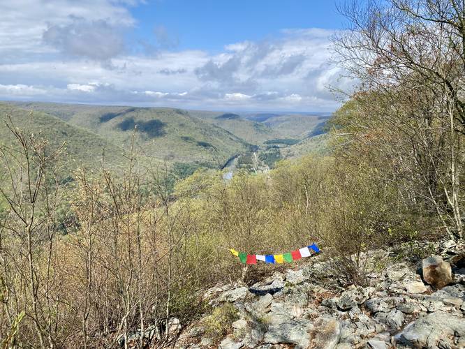
Hanging Rock Overlook at Tiadaghton State Forest in Waterville, Pennsylvania is an easy 0.1-mile roadside vista walk that features views of the PA Grand Canyon, Waterville, and the surrounding mountains.

This is not a hike, but rather a quick road-side walk that leads out to the rocky mountain ridge outcropping that teeters on the edge of the PA Grand Canyon. Hanging Rock is named after the obvious large "hanging" rock ledge that protrudes out from the mountain's ridge. The rock ledge hangs over a ~7-foot deep cave and is about 8-feet tall, surrounded by scattered conglomerate rock boulders.

Views
Hanging Rock Overlook provides views of several points-of-interest, especially for the keen-eyed (mostly-local) hiker. Facing northwest along Pine Creek below is village of Waterville along with the steep surrounding mountains, two of which sport the Bull Run Vista and Waterville Vista. Facing southeast toward the village of Ramsey, Pennsylvania lies the mountain ridge that sports the Stone Cutter Vista located dead-center with Houselander Mountain to the left-hand side. Short Mountain (private land) sits sloping behind Houselander Mountain and in the distant views are the mountains surrounding Jersey Shore, Pennsylvania.

Parking
Visitors will find a small parking lot at the coordinates provided, large enough to fit a few vehicles max.

Pets
Dogs are allowed if leashed and must be cleaned up after.
Explore 203 trails near Waterville, PA

Know Before You Go

  • Hanging Rock Overlook is a very short, easy roadside walk offering scenic views of the PA Grand Canyon, Waterville, and surrounding mountains.
  • The overlook features a unique "hanging" rock ledge and provides views of landmarks such as Waterville, Ramsey, and distant mountains near Jersey Shore.
  • A small parking area is available, and leashed dogs are permitted with clean-up.
Interactive topographic map for Hanging Rock Overlook located in Waterville, PA. Click the "View Map" button to load GPS coordinates and trail markers.
Get directions
Distance
0.1 mi
Difficulty
Easy
Type
Out-and-Back
Est. Time
5 min
Elev. Gain
15'
Rating
0.0
Added
April 23, 2023
Updated
April 23, 2023

Weather Forecast

Overnight
Low 32°F
Mostly Cloudy
Wednesday
High 43°F
Light Rain
Wednesday Night
Low 19°F
Rain And Snow
Thursday
High 25°F
Chance Snow Showers
Thursday Night
Low 13°F
Slight Chance Snow Showers then Mostly Cloudy
Friday
High 29°F
Partly Sunny then Chance Snow Showers
Friday Night
Low 23°F
Chance Snow Showers then Mostly Cloudy
Saturday
High 36°F
Chance Snow Showers
Saturday Night
Low 15°F
Chance Snow Showers
Sunday
High 24°F
Partly Sunny
Sunday Night
Low 13°F
Mostly Cloudy
M.L. King Jr. Day
High 25°F
Mostly Cloudy then Chance Snow Showers
Monday Night
Low 10°F
Chance Snow Showers
Tuesday
High 19°F
Partly Sunny
Loading...
Total Change
15'
Ascent
15'
Descent
15'
Loading...

Download the GPX Data for Offline Use

Supporters get exclusive access to download trail routes to the MyHikes app for offline use. Stay prepared on your adventure, even without an internet connection! Become a Supporter today to unlock this feature and hike with confidence.

Download Hanging Rock Overlook GPX Data to the MyHikes Mobile App

Features

Vista / Lookout Point
Dogs
Camping
PA Wilds logo PA Wilds

Points of interest

  1. Parking

    41.304727, -77.342493
  2. Main Trailhead

    41.304727, -77.342493

Safety information

For your own safety: plan ahead, let someone know where you'll be, and hike at your own risk.

Hazards

Snakes (Rattlesnakes, Copperheads, others)

Availability

All seasons

Surface type

Dirt

Trip Reports (Reviews)

Your opinion matters! Be the first to rate this trail.

Ready to help fellow hikers? Add a trip report to share your experience and provide valuable insights for other hikers!

6.0 miles / 9.7 km
October 26, 2024
Even though you can drive up, I earned my view with a challenging hike up the MST starting at Dam Run Rd (small pull-off for 1 car about 1/4 mile up from where MST crosses the forest rd). First part of climb was hard but neat views up hollow to distract, then once to Tram Rd trail, it was wide, straight, & gradual to finish the climb to the gas pad road. Able to run once on gravel Rebound Rd which leads to Ramsey Rd for the remaining road to vista. Tried to do a more direct/shortcut route at first, but there is deer fencing blocking & making the forest floor grown in, plus the pipeline flat area has tall grass that isn't worth hiking through. Wow, what an impressive 180 degree view of the Pine Creek gorge (one of best for sure), and even better being near sunset! Cool mountain view facing downstream to Ramsey, and then creek views upstream toward Waterville! Will definitely return here (even if I just drive up next time)! Still a great hike too!
Hiking

Explore other routes for this Trail guide, added by the MyHikes' community via Trip Reports (Reviews). To add your own hike as a Community Route for this Trail guide, leave a Trip Report and attached your GPX file!

Popular categories

Scenic mountain view representing vista trails
Vista trails
Scenic gorge of cascades representing waterfall trails
Waterfall hikes
Rugged mountain terrain representing summit trails
Summit trails
Scenic mountain view representing dog-friendly trails
Dog-friendly
Scenic campsite with a view representing camping trails
Camping trails
Appalachian Trail logo representing A.T. hikes
A.T. hikes

You May Also Like

New York's Best Waterfalls - Whether you're planning a day hike, roadside stop, or a leisurely short walk, this guide provides hikers, travelers, and locals alike with 63 different locations to over 100 scenic waterfalls to help plan your next adventure!
Explore

New York's Best Waterfalls

Whether you're planning a day hike, roadside stop, or a leisurely short walk, this guide provides hikers, travelers, and locals alike with 63 different locations to over 100 scenic waterfalls to help plan your next adventure!

Read
🍪 We use cookies to learn about site usage and to serve map tiles. You may block cookies manually in the browser. By continuing you agree. Learn more