The Waterville Vista Loop at Tiadaghton State Forest near Waterville, Pennsylvania is a moderate 6-mile loop hike that features two beautiful vistas with views of Pine Creek, the PA Grand Canyon, and the mountains surrounding Waterville.
Vistas
This hike leads to the Waterville Vista (east) and Upper Pine Bottom Vista (west).
Trails
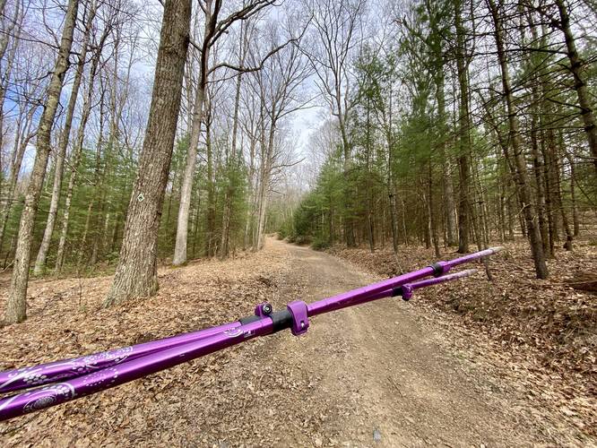
This hike follows several trails in the following order: Plantation Trail (red blazes), unnamed ATV Trails, Button Road, Jack Martin Trail, ATV trails, back to Button Road, and then down the Plantation Trail. Note that the ATV Trails are unnamed and are part of the Haneyville ATV Trail System. Nicknames: This loop, due to its shape, has a few nicknames that hikers can use like "Aviator Sunglasses Loop", "Bow-tie Loop", or "Mosquito Face Loop" as the GPS track vaguely resembles each.
Hike Description
This hike begins along PA-44 at the parking coordinates provided, adjacent to where Upper Pine Bottom Run crosses under the road. The Plantation Trail trailhead is located on the north side of the road where the small parking turnout can be found. The trail begins ascending the mountain at a moderate grade and stays steady for the climb to the top. The Plantation Trail doesn't have much to see along the way but during months when no leaves are on the trees, hikers get obstructed "views" of the surrounding mountains on your way up.
ATV Trail Junction, Left Turn - Mile 0.95
At mile 0.95, hikers will reach a junction with the ATV Trail - noted by the larger rocky substrate that comprises its surface. For this hike, we'll save the best view for last, so take a left-hand turn here to head north.
Button Road - Left Turn - Mile 1.05
Just up the trail by ~0.1-miles from the first junction, hikers will reach Button Road. Take a left-hand turn here to follow this ATV trail as it heads west and eventually bends to the south. Note the evergreen plantations here and west of this junction, which essentially named the ascending trail's name for its very purpose of replanting white pine, hemlock, and what appear to be some firs in this area. The forest floor is wide open and provides more shade due to the thick foliage cover of the evergreens.
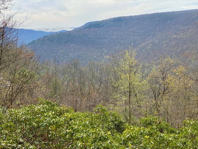
Upper Pine Bottom Vista - Mile 1.6
At mile 1.6, hikers will reach the first vista along this hike - Upper Pine Bottom Vista - located right on Button Road. Upper Pine Bottom Vista provides views of Middle Hill (or Middle Hill Mountain) directly across the way along wit glimpses of the mountain range that extends into the PA Grand Canyon south of Waterville. This vista is a great spot to take a break, sit, and enjoy the views.
Button Road to Short Bushwhack - Mile 1.6 to 2.27
From Upper Pine Bottom Vista, hikers will follow Button Road as it leads north. At mile 2.27, marked by a green ATV Trail sign (as of April 2023), we bushwhacked ~300-feet north from Button Road to reach the other ATV path that follows the Jack Martin Trail. From mile 2.27 to 2.35 you'll hike through a forest that's mostly-open with some smaller trees that fill it in; however, there's no trail here.
Right-Hand Turn (#16) - Mile 2.7
Around mile 2.7, at the sign labeled "#16" (as of April 2023), hikers will want to take a right-hand turn here to veer off of the Jack Martin Trail and back onto an ATV Trail that connects back to Button Road.
Button Road to Plantation Trail - Mile 3.05
Once at Button Road, take a left-hand turn at the #17 sign, then take an immediate right-hand turn to hike back toward the Plantation Trail. When you hit the Plantation Trail, keep left to stay on the ATV Trail to head toward the Waterville Vista.
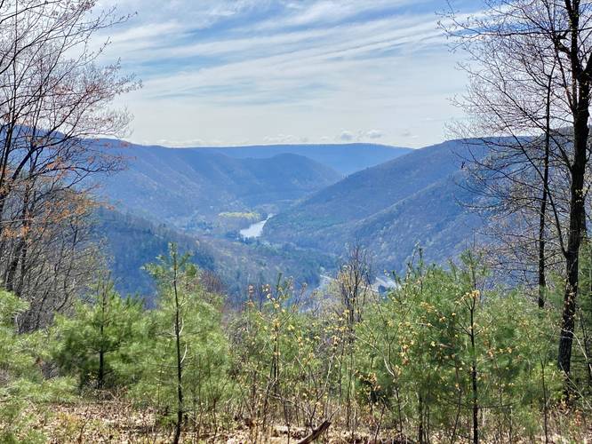
Waterville Vista - Mile 4.05
The ATV Trail will twist and wind its way as it loops south and then east to reach the Waterville Vista around mile 4.05. Here, hikers will get the best views along this hike which include the Waterville area, Pine Creek as it passes through the canyon, the mountain that hosts the Bull Run Vista at its top, and a ragged mountain ridge that sticks far into the PA Grand Canyon south of Waterville. Despite taking ~4-miles to reach this view, it's well-worth the wait. As of April 2023, the 5-foot white pine trees that sit in the view's cutout are posing a threat to overtaking the view here, so this might be available for the next ~10-years or so (circa 2033) if the trees fill in the view.
ATV Trail to Button Road - Mile 4.05 to 4.7
The hike from the Waterville Vista back to Button Road is not hard - hikers will head north from the vista along the ATV Trail until they reach a trail junction around mile 4.65. Take a left-hand turn which leads into another trail junction - then take a right-hand turn at that junction, which is Button Road. Hike Button Road west until you reach the initial Button Road intersection you hiked to earlier.
Plantation Trail to Parking - Mile 5.1 to 6
Finally, hikers will reach the Plantation Trail's northern terminus for the last time. Hike down and back to parking to complete this 6-mile loop.
Parking
Hikers will find a small parking turnout at the coordinates provided along PA-44 near Waterville. The lot is large enough to fit less than 5 vehicles. There are other nearby parking turnouts, albeit they're quite small.
Pets
Dogs are allowed if leashed and must be cleaned up after.
Camping & Backpacking
Tiadaghton State Forest allowed primitive / backcountry / dispersed camping within their own rules and regulations. While we did not find any pre-defined campsites, backpackers may find a spot to setup a tent or hammock camp along this loop. Please follow all state forest rules and regulations if camping.
Warnings
Timber Rattlesnake: This area is known to inhabit the Timber Rattlesnake. Rattlesnakes tend to roam the forest between the months of April and October each year and could be on the trail or sunning themselves in open areas. Additionally, they like to live in rocky outcroppings or hunt near water sources.
ATVs: Hikers should be aware that most of this hike follows trails that allow ATVs to drive along them. The only trail that doesn't permit ATVs along this hike is the Plantation Trail. Watch out for ATVs and move over for them.
Lack of water: This hike has no water sources along the route, so pack in at least 2-liters per person to be safe.
Vistas
This hike leads to the Waterville Vista (east) and Upper Pine Bottom Vista (west).
Trails
This hike follows several trails in the following order: Plantation Trail (red blazes), unnamed ATV Trails, Button Road, Jack Martin Trail, ATV trails, back to Button Road, and then down the Plantation Trail. Note that the ATV Trails are unnamed and are part of the Haneyville ATV Trail System. Nicknames: This loop, due to its shape, has a few nicknames that hikers can use like "Aviator Sunglasses Loop", "Bow-tie Loop", or "Mosquito Face Loop" as the GPS track vaguely resembles each.
Hike Description
This hike begins along PA-44 at the parking coordinates provided, adjacent to where Upper Pine Bottom Run crosses under the road. The Plantation Trail trailhead is located on the north side of the road where the small parking turnout can be found. The trail begins ascending the mountain at a moderate grade and stays steady for the climb to the top. The Plantation Trail doesn't have much to see along the way but during months when no leaves are on the trees, hikers get obstructed "views" of the surrounding mountains on your way up.
ATV Trail Junction, Left Turn - Mile 0.95
At mile 0.95, hikers will reach a junction with the ATV Trail - noted by the larger rocky substrate that comprises its surface. For this hike, we'll save the best view for last, so take a left-hand turn here to head north.
Button Road - Left Turn - Mile 1.05
Just up the trail by ~0.1-miles from the first junction, hikers will reach Button Road. Take a left-hand turn here to follow this ATV trail as it heads west and eventually bends to the south. Note the evergreen plantations here and west of this junction, which essentially named the ascending trail's name for its very purpose of replanting white pine, hemlock, and what appear to be some firs in this area. The forest floor is wide open and provides more shade due to the thick foliage cover of the evergreens.
Upper Pine Bottom Vista - Mile 1.6
At mile 1.6, hikers will reach the first vista along this hike - Upper Pine Bottom Vista - located right on Button Road. Upper Pine Bottom Vista provides views of Middle Hill (or Middle Hill Mountain) directly across the way along wit glimpses of the mountain range that extends into the PA Grand Canyon south of Waterville. This vista is a great spot to take a break, sit, and enjoy the views.
Button Road to Short Bushwhack - Mile 1.6 to 2.27
From Upper Pine Bottom Vista, hikers will follow Button Road as it leads north. At mile 2.27, marked by a green ATV Trail sign (as of April 2023), we bushwhacked ~300-feet north from Button Road to reach the other ATV path that follows the Jack Martin Trail. From mile 2.27 to 2.35 you'll hike through a forest that's mostly-open with some smaller trees that fill it in; however, there's no trail here.
Right-Hand Turn (#16) - Mile 2.7
Around mile 2.7, at the sign labeled "#16" (as of April 2023), hikers will want to take a right-hand turn here to veer off of the Jack Martin Trail and back onto an ATV Trail that connects back to Button Road.
Button Road to Plantation Trail - Mile 3.05
Once at Button Road, take a left-hand turn at the #17 sign, then take an immediate right-hand turn to hike back toward the Plantation Trail. When you hit the Plantation Trail, keep left to stay on the ATV Trail to head toward the Waterville Vista.
Waterville Vista - Mile 4.05
The ATV Trail will twist and wind its way as it loops south and then east to reach the Waterville Vista around mile 4.05. Here, hikers will get the best views along this hike which include the Waterville area, Pine Creek as it passes through the canyon, the mountain that hosts the Bull Run Vista at its top, and a ragged mountain ridge that sticks far into the PA Grand Canyon south of Waterville. Despite taking ~4-miles to reach this view, it's well-worth the wait. As of April 2023, the 5-foot white pine trees that sit in the view's cutout are posing a threat to overtaking the view here, so this might be available for the next ~10-years or so (circa 2033) if the trees fill in the view.
ATV Trail to Button Road - Mile 4.05 to 4.7
The hike from the Waterville Vista back to Button Road is not hard - hikers will head north from the vista along the ATV Trail until they reach a trail junction around mile 4.65. Take a left-hand turn which leads into another trail junction - then take a right-hand turn at that junction, which is Button Road. Hike Button Road west until you reach the initial Button Road intersection you hiked to earlier.
Plantation Trail to Parking - Mile 5.1 to 6
Finally, hikers will reach the Plantation Trail's northern terminus for the last time. Hike down and back to parking to complete this 6-mile loop.
Parking
Hikers will find a small parking turnout at the coordinates provided along PA-44 near Waterville. The lot is large enough to fit less than 5 vehicles. There are other nearby parking turnouts, albeit they're quite small.
Pets
Dogs are allowed if leashed and must be cleaned up after.
Camping & Backpacking
Tiadaghton State Forest allowed primitive / backcountry / dispersed camping within their own rules and regulations. While we did not find any pre-defined campsites, backpackers may find a spot to setup a tent or hammock camp along this loop. Please follow all state forest rules and regulations if camping.
Warnings
Timber Rattlesnake: This area is known to inhabit the Timber Rattlesnake. Rattlesnakes tend to roam the forest between the months of April and October each year and could be on the trail or sunning themselves in open areas. Additionally, they like to live in rocky outcroppings or hunt near water sources.
ATVs: Hikers should be aware that most of this hike follows trails that allow ATVs to drive along them. The only trail that doesn't permit ATVs along this hike is the Plantation Trail. Watch out for ATVs and move over for them.
Lack of water: This hike has no water sources along the route, so pack in at least 2-liters per person to be safe.