Elk Run Overlook at Tioga State Forest in Marshlands, Pennsylvania is a moderate 3.3-mile loop hike that features views from Cedar Mountain toward Gaines, including a view of the Shin Hollow Vista in the distance. Not to be confused with the official drive-up view, Elk Run Vista located on Cedar Mountain Road, this is a hike that leads up to a beautiful view above Elk Run on Cedar Mountain.
Mitchell Hollow Trail to Gas Pipeline - Mile 0 to 0.75
The trail leads in from the yellow gate up toward a private cabin, which is occupied seasonally with a lease by the state of Pennsylvania. Do not disturb the private camp. The trail leads up along the hollow through an unmaintained overgrown trail -- simply look for a low grade trail on the right-hand side of the service road on your way uphill, below the private camp. Once on-trail, the hike up this western section of Cedar Mountain is straight forward -- follow the old logging grade up the mountain. There isn't much to see along the way and as of January 2025, the trail did not have any blaze markers to follow, so you need to be able to read the terrain well to navigate while crossing blowdown trees and overgrown shrubs. The hardest part of the hike is near the top of the mountain where it picks up in elevation gain before flattening out. Once you reach the flat elevation grade, you'll find an old logging trail that runs through the woods -- simply follow this trail out to the natural gas pipeline which will be reached around mile 0.75.
Timber rattlesnakes: This area is home to the Timber Rattlesnake which can be found roaming the forest floor between the end of April and early October each year. They often like to drink from creeks and sun themselves in wide open areas, so the pipeline may be a place where you could encounter a basking rattler. Be on the lookout and give any you find plenty of space.
Trails
This hike follows two named trails, a forest road, and a gas pipeline in the following order: Mitchell Hollow Trail, natural gas pipeline, Water Trough Hollow Trail, Cedar Mountain Road, McCracken Road.Hiking to Elk Run Overlook
This hike begins along McCracken Road in Mashlands at the Mitchell Hollow Trail sign at the coordinates provided. There's a parking turnout just before the forest road gate. Do not block the forest road gate.Mitchell Hollow Trail to Gas Pipeline - Mile 0 to 0.75
The trail leads in from the yellow gate up toward a private cabin, which is occupied seasonally with a lease by the state of Pennsylvania. Do not disturb the private camp. The trail leads up along the hollow through an unmaintained overgrown trail -- simply look for a low grade trail on the right-hand side of the service road on your way uphill, below the private camp. Once on-trail, the hike up this western section of Cedar Mountain is straight forward -- follow the old logging grade up the mountain. There isn't much to see along the way and as of January 2025, the trail did not have any blaze markers to follow, so you need to be able to read the terrain well to navigate while crossing blowdown trees and overgrown shrubs. The hardest part of the hike is near the top of the mountain where it picks up in elevation gain before flattening out. Once you reach the flat elevation grade, you'll find an old logging trail that runs through the woods -- simply follow this trail out to the natural gas pipeline which will be reached around mile 0.75. Gas Pipeline to Elk Run Overlook - Mile 0.75 to 0.95
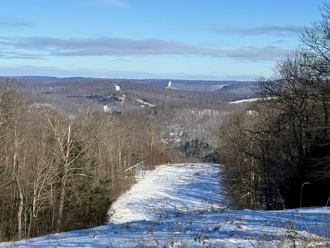
Once on the natural gas pipeline, the hike leads due north to reach the Elk Run Overlook. The terrain will lead uphill slightly before dipping back down the mountain. The best view is from just below the crest in the hill. From Elk Run Overlook, you'll find views of Shin Hollow Vista in the distance -- it's the pipeline on your right-hand side. Additionally, you can see a glimpse of the top plateau of Elephant Mountain located to the left of the pipeline on the left-hand side of the view.Hiking Out via Water Trough Hollow Trail - Mile 0.95 to 2.4
If you wish to follow an even-less maintained trail that's difficult to find and follow, you'll want to head to the Water Trough Hollow Trail. Note that this trail is pretty annoying, more so than the Mitchell Hollow Trail, and thus I would instead suggest hikers make this an out-and-back hike and only walk along the Mitchell Hollow Trail for a hard 1.8-mile out-and-back. If you wish to follow this route in its entirety, read further. The hike from the Elk Run Overlook leads south along the pipeline for almost exactly 1-mile. The Water Trough Hollow Trail is not maintained and hard to find, but be on the lookout for a cut-out in the woods that appears to be a trail... this recording actually misses the trailhead along the pipeline for the Water Trough Hollow Trail so make sure to bring a reliable offline map, like the MyHikes app. Once near the Water Trough Hollow Trail, you'll likely have to bushwhack your way down to reach an old logging grade that looks like a trail. This is the Water Trough Hollow Trail -- full of blowdown trees and overgrown shrubs that haven't been maintained in ages. Eventually, you'll follow this rugged path down to reach the Cedar Mountain Road at mile 2.4.Cedar Mountain Road to Parking - Mile 2.4 to 3.3
The last stretch of this hike is easy. Once you hop off of the Water Trough Hollow Trail, you'll take a left-hand turn to hike downhill to reach McCracken Road. Follow McCracken Road back to the Mitchell Hollow Trail parking area to complete this 3.3-mile loop hike.Parking
Hikers will find parking at the coordinates provided, located along McCracken Road. There is a small parking turnout located just before the yellow service road gate. Do not block the yellow gate.Private Property
There's a private camp located uphill from the trail. Please respect the camp owners.Warnings
Bushwhacking: This hike leads through unmaintained trails that seemingly haven't been touched by the state forest in a very long time. You will need to hike over dozens of downed trees. The Water Trough Hollow Trail portion of the hike (in the south part of the loop) is even more difficult to locate and navigate. This trail is much easier to hike during the winter than when leaves have filled-in the forest.Timber rattlesnakes: This area is home to the Timber Rattlesnake which can be found roaming the forest floor between the end of April and early October each year. They often like to drink from creeks and sun themselves in wide open areas, so the pipeline may be a place where you could encounter a basking rattler. Be on the lookout and give any you find plenty of space.