Shin Hollow Vista at Tioga State Forest near Westfield, Pennsylvania is a moderate 2.8-mile out-and-back hike that leads to a beautiful vista above Pine Creek and PA-6.
Trails
This hike follows one named trail - Shin Hollow Trail - and a natural gas pipeline.
Hike Description
This trail was mapped on Drift Boards mid-December, 2022, so the experience is based on that. Drift Boarding is a combination of hiking, snowshoeing, and cross-country skiing combined into one. Despite this being a Winter mapping trip, some observations (and previous experience hiking here) are worth noting such as: half of the pipeline appears to be mowed during warm months, there's a new (as of ~2021-2022) grouse fence at the Shin Hollow Trail / pipeline junction, and the pipeline vista is accessible year-round, if you're willing to hike through snow to reach it.
The trailhead can be found across the street from the small parking turnout at the coordinates provided - this is the trailhead for the Shin Hollow Trail. There's a yellow metal gate which is generally closed year-round, except for during hunting season. The gate can usually be found open from November - mid-January each year for hunters. The service road (aka Shin Hollow Trail) head uphill at a moderate grade for about 0.45-miles before it starts to level out as it approaches the pipeline.
Right-Hand Turn at Pipeline - Mile 0.55
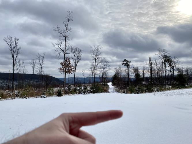
At mile 0.55, hikers will reach a right-hand turn at the natural gas pipeline. Note that during colder months when the leaves are off of the trees, there's a really nice obstructed view of the surrounding mountains at this junction. After taking the right-hand turn, the pipeline undulates slightly as it heads uphill then back down toward the vista along gradual grades. Along the way, hikers can enjoy the open wide and rolling terrain of the pipeline. Upon this outing, skiing down these rolling hills was a lot of fun and made for a faster Winter hike.
Vista - Mile 1.3 and 1.4
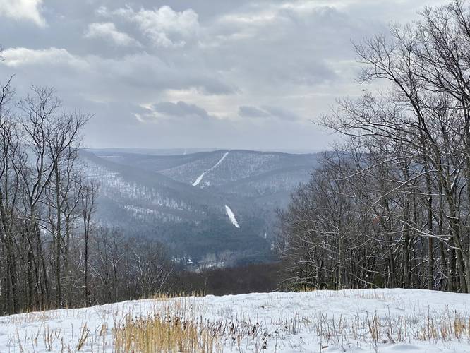
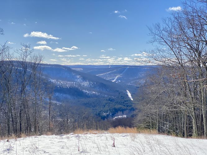
As the rolling terrain starts to head back downhill, hikers will notice the vista in the distance, but it takes just a few more minutes to reach the best views, which sit at mile 1.3 and 1.4. At mile 1.4, where this track stops, hikers will get a view of Pine Creek, Lick Run Hill, the mountains surrounding PA Route 6, and the pipeline as it winds up and down the mountain range in the distance. Just below the vista is a large rock barrier with an old metal fence to prevent private land owners from driving vehicles on the pipeline. Note that not too far beyond that barrier, the public land ends. There may be more views below, but I turned back here.
Parking
Hikers will find a small parking lot at the coordinates provided. The lot can hold a half-dozen vehicles or so. During the Winter, the lot is not plowed, so you may want to bring a shovel in case of snow during late November - April.
Pets
Dogs are allowed if leashed and their waste should be carried out by the hiker.
Camping & Backpacking
While camping and backpacking are permitted at Tioga State Forest, there are no good places to setup a campsite along this trail. If looking to camp nearby, maybe check out the more open areas (as of December 2022) along the Shin Hollow Trail south of the pipeline junction. Please follow all state forest rules and regulations when dispersed / backcountry / primitive camping.
Trails
This hike follows one named trail - Shin Hollow Trail - and a natural gas pipeline.
Hike Description
This trail was mapped on Drift Boards mid-December, 2022, so the experience is based on that. Drift Boarding is a combination of hiking, snowshoeing, and cross-country skiing combined into one. Despite this being a Winter mapping trip, some observations (and previous experience hiking here) are worth noting such as: half of the pipeline appears to be mowed during warm months, there's a new (as of ~2021-2022) grouse fence at the Shin Hollow Trail / pipeline junction, and the pipeline vista is accessible year-round, if you're willing to hike through snow to reach it.
The trailhead can be found across the street from the small parking turnout at the coordinates provided - this is the trailhead for the Shin Hollow Trail. There's a yellow metal gate which is generally closed year-round, except for during hunting season. The gate can usually be found open from November - mid-January each year for hunters. The service road (aka Shin Hollow Trail) head uphill at a moderate grade for about 0.45-miles before it starts to level out as it approaches the pipeline.
Right-Hand Turn at Pipeline - Mile 0.55
At mile 0.55, hikers will reach a right-hand turn at the natural gas pipeline. Note that during colder months when the leaves are off of the trees, there's a really nice obstructed view of the surrounding mountains at this junction. After taking the right-hand turn, the pipeline undulates slightly as it heads uphill then back down toward the vista along gradual grades. Along the way, hikers can enjoy the open wide and rolling terrain of the pipeline. Upon this outing, skiing down these rolling hills was a lot of fun and made for a faster Winter hike.
Vista - Mile 1.3 and 1.4
As the rolling terrain starts to head back downhill, hikers will notice the vista in the distance, but it takes just a few more minutes to reach the best views, which sit at mile 1.3 and 1.4. At mile 1.4, where this track stops, hikers will get a view of Pine Creek, Lick Run Hill, the mountains surrounding PA Route 6, and the pipeline as it winds up and down the mountain range in the distance. Just below the vista is a large rock barrier with an old metal fence to prevent private land owners from driving vehicles on the pipeline. Note that not too far beyond that barrier, the public land ends. There may be more views below, but I turned back here.
Parking
Hikers will find a small parking lot at the coordinates provided. The lot can hold a half-dozen vehicles or so. During the Winter, the lot is not plowed, so you may want to bring a shovel in case of snow during late November - April.
Pets
Dogs are allowed if leashed and their waste should be carried out by the hiker.
Camping & Backpacking
While camping and backpacking are permitted at Tioga State Forest, there are no good places to setup a campsite along this trail. If looking to camp nearby, maybe check out the more open areas (as of December 2022) along the Shin Hollow Trail south of the pipeline junction. Please follow all state forest rules and regulations when dispersed / backcountry / primitive camping.