The hike to Dundelbachfälle (Dundelbach Falls) in Lungern, Switzerland is an easy 1.1 km out-and-back walk that leads from the center of town to the base of the 150m (492-feet) tall waterfall.
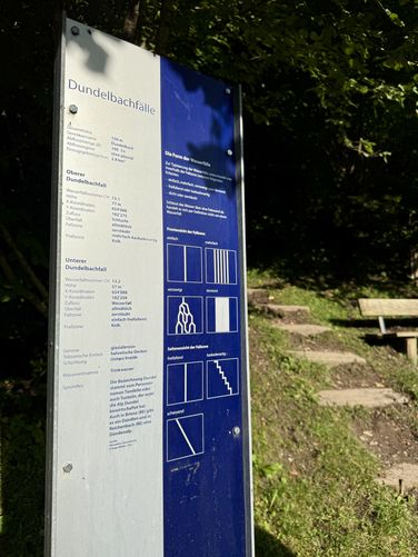
The road crosses Dundelbach (Dundel stream) and on the other side sits a public hiking trail that leads to the waterfall. Here, visitors will find detailed signage of Dundelbach Falls and its comprising Upper and Lower tiers. Follow this trail uphill for a short distance along a moderate grade to reach the base of Lower Dundelbach Falls. While reaching the waterfall's base, be mindful of the jagged and uneven trail surface that sits next to a short but steep cliff.
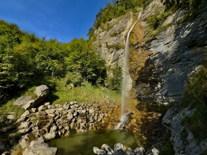
From the base of Lower Dundelbach Falls, you'll find a scenic and calming setting of the lower tier of the waterfall as it spills down the mountain and into a tranquil pool before the water flows down to Lungerersee (Lake Lungern). Here, visitors will be able to enjoy just a portion of Lower Dundelbach Falls' total height of 57m. Regardless of the total visible height of the waterfall, it's a splendid and secluded place to enjoy nature in Switzerland without crowds (as of September 2025).
After exploring the waterfall, the walk back to the parking lot is an easy 0.55km walk with more cows, clanging cowbells, quaint houses, and gondolas rising high from the mountain valley.
Exploring Dundelbach Falls
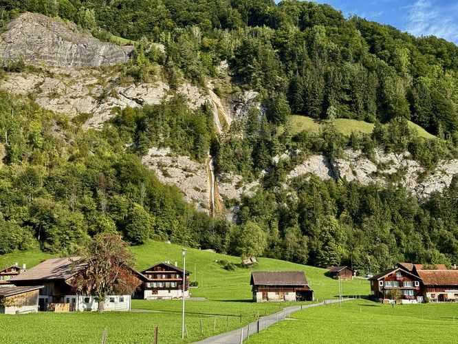
Visitors to Dundelbachfälle (Dundelbach Falls) will find the quaint, picturesque town of Lungern nestled at the southern end of Lungerersee (Lake Lungern) where the short hike begins. There is not official trailhead, but instead hikers will start at the public (paid) parking lot just south of Campingplatz Obsee. Following the road Hinterseestrasse northwest, you'll pass through a small section of the town where scenic houses dot the hillsides, see cows grazing with a constant song of their clanging cowbells, the occasional gondola rising high above the valley headed toward the summit of Turren Mountain, and the full 50m of Upper and Lower Dundelbach Falls as it cascades down the mountainside. As you hike toward the base of the waterfall, you'll find the best views of the entire two tiers of Dundelbach Falls' cascades from the road.The road crosses Dundelbach (Dundel stream) and on the other side sits a public hiking trail that leads to the waterfall. Here, visitors will find detailed signage of Dundelbach Falls and its comprising Upper and Lower tiers. Follow this trail uphill for a short distance along a moderate grade to reach the base of Lower Dundelbach Falls. While reaching the waterfall's base, be mindful of the jagged and uneven trail surface that sits next to a short but steep cliff.
From the base of Lower Dundelbach Falls, you'll find a scenic and calming setting of the lower tier of the waterfall as it spills down the mountain and into a tranquil pool before the water flows down to Lungerersee (Lake Lungern). Here, visitors will be able to enjoy just a portion of Lower Dundelbach Falls' total height of 57m. Regardless of the total visible height of the waterfall, it's a splendid and secluded place to enjoy nature in Switzerland without crowds (as of September 2025).
After exploring the waterfall, the walk back to the parking lot is an easy 0.55km walk with more cows, clanging cowbells, quaint houses, and gondolas rising high from the mountain valley.