Loading...

🎉 Enjoy a Free 7-Day Supporter Trial and Unlock Exclusive Perks — No Credit Card Required. Learn more.

Cavanaugh Nature Trail

Directions
Map
Pictures
Send to App
Distance:
0.6 Miles / 1.0 km
Type:
Loop
Difficulty:
Easy
Time to Hike:
~18 minutes
Features:
PA Wilds
Surface Type:
Dirt
Park:
Tioga State Forest
Town:
Wellsboro, Pennsylvania
Directions:
41.777571, -77.371893
Added:
April 07, 2020
Updated:
August 30, 2022
Copy Trail Link Hiking this trail? Send a friend or family member a link to this trail guide for your own safety. Hike at your own risk (disclaimer)
Loading...
Loading...
21'

Total Change
23'

Ascent
24'

Descent

Download the Trail Route for Offline Use

Supporters get exclusive access to download trail routes to the MyHikes app for offline use. Stay prepared on your adventure, even without an internet connection! Become a Supporter today to unlock this feature and hike with confidence.

Send to App

Cavanaugh Nature Trail

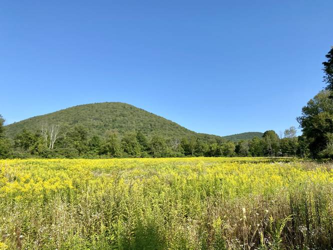
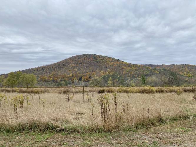
The Cavanaugh Nature Trail at Tioga State Forest near Wellsboro, Pennsylvania is an easy 0.6-mile loop trail that passes through open fields in the middle of a mountainous valley. During warmer months, wildflowers can be found growing here.

The trail is a very flat which makes for an easy walk through the fields. This recording follows the outer-most loop, but there are several bisecting trails that hikers can take to cut across different portions of the outer loop.

After exploring this trail, hikers have the option to take a walk down the Pine Creek Trail since the trailhead for the Cavanaugh Nature Trail sits alongside the Pine Creek Trail.

History
This trail was built as an Eagle Scout project in 2018 by Nathan Redell's Troop 2046.

Parking
Hikers can find parking at the coordinates provided at the Cavanaugh Access Lot, which is also for the Pine Creek Trail. The parking lot is large enough to fit about a dozen vehicles.

Pets
Dogs are allowed if leashed.
Explore 280 trails near Wellsboro, PA
  1. Parking

    41.777571, -77.371893
  2. Main Trailhead

    41.77731, -77.372135
  3. Oak Point Mountain above fields of Goldenrod

    41.775908, -77.372803
    Oak Point Mountain above fields of Goldenrod
Explore other routes for this Trail guide, added by the MyHikes' community via Trip Reports. To add your own hike as a Community Route for this Trail guide, leave a Trip Report with an attached GPX file.

Hazards

Ticks - Lyme Disease More Info (CDC)

Seasons

All

Trip Reports

Trail Guide By:
Admin user profile picture
0.6 miles / 1.0 km
0.6 miles / 1.0 km
August 22, 2023
Love this little area. Spotted some rabbits and a skunk.
Hiking
0.8 miles / 1.3 km
August 28, 2022
Dogs Hiking
0.8 miles / 1.3 km
August 28, 2022
Nice short walk in late August. Goldenrod and other wildflowers were in bloom along with some wild grapes growing on vines. We followed a different path than the original walk here for about 0.8 miles instead of the 0.6 of the outer loop.
Dogs Hiking
0.6 miles / 1.0 km
October 11, 2020
Hiking

Weather Forecast

In Wellsboro, PA

Explore Hiking Trails

You May Also Like

Colorado's Million Dollar Highway - Plan a day's drive adventure along the iconic Million Dollar Highway in Colorado. Explore the best short trails, roadside stops, waterfalls, vistas, ghost towns, and hot springs within a ~6 hour road trip.
Explore

Colorado's Million Dollar Highway

Plan a day's drive adventure along the iconic Million Dollar Highway in Colorado. Explore the best short trails, roadside stops, waterfalls, vistas, ghost towns, and hot springs within a ~6 hour road trip.

Read
New York's Best Waterfalls - Whether you're planning a day hike, roadside stop, or a leisurely short walk, this guide provides hikers, travelers, and locals alike with 63 different locations to over 100 scenic waterfalls to help plan your next adventure!
Explore

New York's Best Waterfalls

Whether you're planning a day hike, roadside stop, or a leisurely short walk, this guide provides hikers, travelers, and locals alike with 63 different locations to over 100 scenic waterfalls to help plan your next adventure!

Read

Before you boogie...

Find our trail guides useful? Consider becoming a Supporter to unlock perks!

MyHikes is an indie platform that makes exploring public trails easier for everyone. The platform has no investors, no ads, and is owned and operated by one person, Dave Miller. Dave has personally mapped and written over 1,800 trail guides on MyHikes for the public to explore. MyHikes has helped millions outdoor enthusiasts plan their next adventure.

But it takes a lot of time 🕦, money 💰, work, and espresso shots ☕ to run MyHikes, including hiking , mapping , writing , and publishing new trails with high-quality (accurate) information... along with software engineering (coding) the platform like building new features, website and mobile app development (iOS and Android), site maintainance . and much much more.

Supporters unlock website and mobile app perks with an annual one-time payment of $25 (you renew) 😎👍. Or you can simply make a Donation of your choice. Otherwise, you can support us by telling your friends about MyHikes - both quick and free 🎉

Admin user profile picture

Dave Miller
MyHikes Founder