Loading...

WINTER SALE! 50% OFF Supporter Accounts — now through January 31st. Learn More.

Campbell Creek and Lanier Falls Hike

Beauty and tranquility are often discovered when you least expect them. Sitting amongst countless farms in the Eastern Piedmont, Raven Rock State Park is probably not at the top of many people’s hiking wish lists. But maybe it should be. The park’s namesake attraction, Raven Rock, is a massive 150-foot bluff above the mighty Cape Fear River.

While hordes of visitors hike to Raven Rock, you should go west on the Campbell Creek Loop Trail. This trail is not only much quieter, it features small streams hidden between ridges, an impressive river-wide drop called Lanier Falls, and the crystal clear water of Campbell Creek. If the water level is up, Lanier Falls is a surprising site this far east of the mountains. The 2-foot shelf drop spans the entire river, more than 200 feet of roiling brown water. Campbell Creek is the highlight of this trip with its clear water, pebble shoals, and rocky bluffs. The trail rarely strays more than 10 feet away from the creek providing an intimate hike as it flows downstream to the Cape Fear River. This hike is perfect for kids as it allows them to explore the creek with very minimal risk.

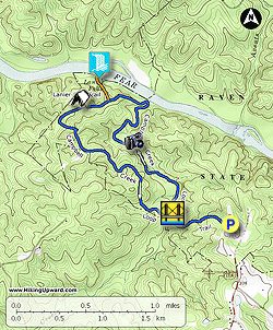
  • Mile 0.0 – The Campbell Creek Loop Trail (blue circle blaze) starts on the left side of the visitors center parking lot. Immediately you’ll reach a T-junction, turn right on the trail. The left trail is a connection to the Raven Rock Loop Trail. You’ll begin descending moderately through pine and hardwood forest.
  • Mile 0.5 – Cross an elaborate wood bridge over Campbell Creek. On the other side the loop trail begins. Turn right to hike the lower end of the loop trail first.
  • Mile 0.7 – The trail begins to intimately follow Campbell Creek as it weaves it way towards the Cape Fear River. You’ll first encounter numerous sand and pebble shoals beside the creek.
  • Mile 1.0 – Campbell Creek splits in two around a large island.
  • Mile 1.5 – A short section of rapids in the creek with an interesting rock formation beyond.
  • Mile 2.1 – Where the loop trail turns left follow a short spur trail to the spot where Campbell Creek flows into the Cape Fear River.
  • Mile 2.5 – T-junction with the Lanier Falls Trail (orange triangle blaze). Turn right and begin descending the bluffs towards the river.
  • Mile 2.7 – Trail ends at Lanier Falls, a powerful Class II rapid across the entire length of the Cape Fear River.
  • Mile 3.0 – Turn right on the Campbell Creek Loop Trail to hike the upper portion back to the parking lot.
  • Mile 3.2 – Family Wilderness Campground on the right for backpackers.
  • Mile 3.4 – Junction with service road on the right. For the next 1.8 miles the trail climbs up and down ridges that separate many small tributaries that feed into Campbell Creek.
  • Mile 4.3 – At the loop junction turn right and cross the bridge over Campbell Creek.
  • Mile 4.8 – Hike ends at the visitors center.
By HikingUpward Contributor: Zach Robbins
Explore 1 trail near Lillington, NC

Know Before You Go

  • The Campbell Creek Loop Trail in Raven Rock State Park offers a quieter alternative to the more popular Raven Rock trail.
  • The hike features diverse scenery including Campbell Creek's clear water, pebble shoals, and bluffs, as well as Lanier Falls, a wide drop across the Cape Fear River.
  • The trail is family-friendly and allows for creek exploration with minimal risk.
Interactive topographic map for Campbell Creek and Lanier Falls Hike located in Lillington, NC. Click the "View Map" button to load GPS coordinates and trail markers.
Get directions
Distance
4.8 mi
Difficulty
Easy
Type
Loop
Est. Time
2.4 hrs
Elev. Gain
657'
Rating
0.0
Added
March 22, 2025
Updated
April 06, 2025

Weather Forecast

Loading...
Total Change
221'
Ascent
657'
Descent
659'
Loading...

Download the GPX Data for Offline Use

Supporters get exclusive access to download trail routes to the MyHikes app for offline use. Stay prepared on your adventure, even without an internet connection! Become a Supporter today to unlock this feature and hike with confidence.

Download Campbell Creek and Lanier Falls Hike GPX Data to the MyHikes Mobile App

Features

Dogs
Waterfalls
Camping
Water Source

Points of interest

  1. Parking

    35.46397, -78.914218
  2. Main Trailhead

    35.46397, -78.914218

Safety information

For your own safety: plan ahead, let someone know where you'll be, and hike at your own risk.

Hazards

Snakes (Rattlesnakes, Copperheads, others)
Poison Ivy or Poison Oak

Markers

Blaze Color

Blue

Availability

All seasons

Surface type

Dirt

Trip Reports (Reviews)

Your opinion matters! Be the first to rate this trail.

Ready to help fellow hikers? Add a trip report to share your experience and provide valuable insights for other hikers!

No community routes found. To add your own hike as a Community Route for this Trail guide, leave a Trip Report with an attached GPX file.

Popular categories

Scenic mountain view representing vista trails
Vista trails
Scenic gorge of cascades representing waterfall trails
Waterfall hikes
Rugged mountain terrain representing summit trails
Summit trails
Scenic mountain view representing dog-friendly trails
Dog-friendly
Scenic campsite with a view representing camping trails
Camping trails
Appalachian Trail logo representing A.T. hikes
A.T. hikes

You May Also Like

25 Best Day Hikes in North Carolina - Discover the top 25 best day hikes in North Carolina, from breathtaking waterfalls to mountain peaks. Explore hidden gems, scenic views, and trails suitable for all skill levels, perfect for your next outdoor adventure.
Explore

25 Best Day Hikes in North Carolina

Discover the top 25 best day hikes in North Carolina, from breathtaking waterfalls to mountain peaks. Explore hidden gems, scenic views, and trails suitable for all skill levels, perfect for your next outdoor adventure.

Read
Colorado's Million Dollar Highway - Plan a day's drive adventure along the iconic Million Dollar Highway in Colorado. Explore the best short trails, roadside stops, waterfalls, vistas, ghost towns, and hot springs within a ~6 hour road trip.
Explore

Colorado's Million Dollar Highway

Plan a day's drive adventure along the iconic Million Dollar Highway in Colorado. Explore the best short trails, roadside stops, waterfalls, vistas, ghost towns, and hot springs within a ~6 hour road trip.

Read
Glacier's Going-to-the-Sun Road - Discover the breathtaking beauty of Glacier National Park along the iconic Going-to-the-Sun Road. From stunning roadside stops to picturesque waterfalls and vistas, this engineering marvel offers endless opportunities for exploration.
Explore

Glacier's Going-to-the-Sun Road

Discover the breathtaking beauty of Glacier National Park along the iconic Going-to-the-Sun Road. From stunning roadside stops to picturesque waterfalls and vistas, this engineering marvel offers endless opportunities for exploration.

Read
🍪 We use cookies to learn about site usage and to serve map tiles. You may block cookies manually in the browser. By continuing you agree. Learn more