The Burdic Run Falls Trail at Tioga State Forest near Wellsboro, Pennsylvania is a moderate 0.8-mile out-and-back trail that leads down to the top of a massive and extremely dangerous waterfall, Burdic Run Falls which spills down approximately 50 feet or more into the PA Grand Canyon. To reach this trailhead, hikers must first hike in on the Seimons Trail, which makes this at the least a 2.1-mile out-and-back trek in total.
Hikers must note that this trail connects to the West Rim Trail in two places, but this hike begins at the unmarked trailhead about 100-feet from the end of the Seimons Trail. This trail is unmarked, non-blazed, unmaintained, and crosses Burdic Run creek several times before reaching the top of Burdic Run Falls.
The trail is not easy to find - the easiest way to find it is to hike to the end of the Seimons Trail and hike straight along the West Rim Trail (orange blazes) for no more than 100-feet. On your left-hand side of the West Rim Trail, there will be an open field clearing - this is the trailhead for the Burdic Run Falls Trail.
The trail then heads downhill along a gradual grade along Burdic Run creek. Eventually the trail reaches Burdic Run creek forcing hikers to start creek crossing. The creek is generally fairly shallow, even after a week of moderate rainfall. At the first creek crossing, hikers will notice the trail also heads back uphill here and connects back to the West Rim Trail, which hikers can use to make a loop hike.
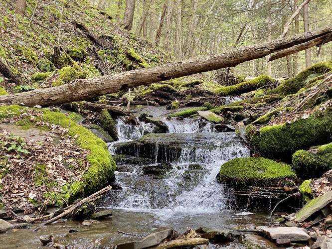
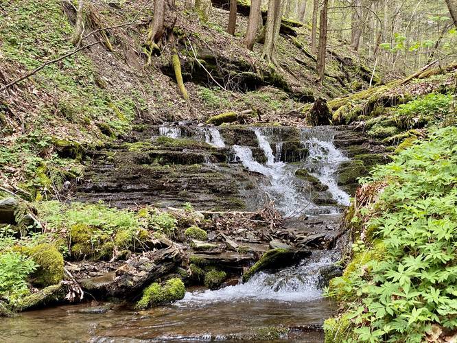
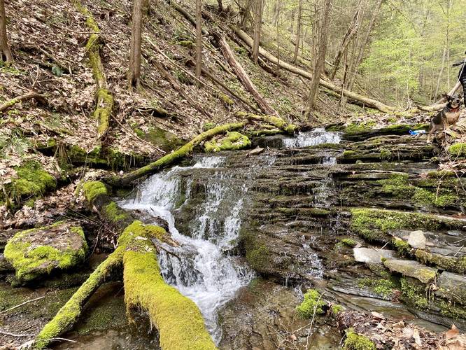
Hiking downstream after the first creek crossing is not the easiest since a lot of the rocks are extremely slippery. Take your time and hike at your own risk, but also enjoy the small 3 to 5-foot waterfalls that cascade down Burdic Run creek before reaching the main 50-foot waterfall Burdic Run Falls. Also note that the trail will disappear and then reappear several times as you hike down Burdic Run crossing the creek a few times.
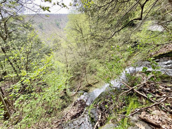
Finally, after crossing Burdic Run creek about four or five times, hikers will reach a point in the trail with a tunnel view with a vista of the PA Grand Canyon mountains across Pine Creek. The obvious drop-off vista at the end of the hike is the massive Burdic Run Falls waterfall.
The hike stops at the top of Burdic Run Falls; however, as of May 2020, some hikers or ice climbers have setup a sketchy ladder that leads down to a very slippery and extremely dangerous cliff edge alongside the waterfall.
The hike back up is identical to the waterfall, with the exception that hikers can loop back to the Seimons Trail along the West Rim Trail instead of hiking back along the Burdic Run Falls Trail. Note that the more difficult hike back is along the West Rim Trail loop portion.
Burdic Run Falls
This waterfall is a 50-foot (or taller) free falling cascade that spills down Burdic Run and into the Grand Canyon of Pennsylvania. There is no way to reach the base of the waterfall without probably kayaking down Pine Creek and hiking in from Pine Creek.
Vista Point
At the top of Burdic Run Falls is a vista into the PA Grand Canyon with views of the mountains across Pine Creek.
Dangers
Hikers will find Burdic Run creek has several cascades and rock ledges that are necessary to climb or scale in order to reach Burdic Run Falls. These rock ledges can be slippery and sketchy. Additionally, at Burdic Run Falls, the waterfall cascades down a 50-foot, or taller, cliff side. Rock ledges and cliffs here should be taken seriously. Last, as of May 2020, some hikers or ice climbers installed a sketchy ladder that leads down from the top of Burdic Run Falls to a very wet and slippery rock ledge about 10-feet below the top. Below this waterfall-adjacent rock ledge is an additional 40-foot sheer drop-off. Hike at your own risk.
Parking
Hikers will find a small parking turnout next to the Seimons Trail at the coordinates provided, but there's not much space.
Pets
Dogs are allowed if leashed.
Winter Road Conditions
Tioga State Forest does not maintain this road during the winter. Do not attempt driving on this road without proper equipment including snow tires and/or chains unless the road is clear. High wind storms may also cause trees to fall across the road, making the road impassible. If you plan to visit during the winter, plan accordingly.
Hikers must note that this trail connects to the West Rim Trail in two places, but this hike begins at the unmarked trailhead about 100-feet from the end of the Seimons Trail. This trail is unmarked, non-blazed, unmaintained, and crosses Burdic Run creek several times before reaching the top of Burdic Run Falls.
The trail is not easy to find - the easiest way to find it is to hike to the end of the Seimons Trail and hike straight along the West Rim Trail (orange blazes) for no more than 100-feet. On your left-hand side of the West Rim Trail, there will be an open field clearing - this is the trailhead for the Burdic Run Falls Trail.
The trail then heads downhill along a gradual grade along Burdic Run creek. Eventually the trail reaches Burdic Run creek forcing hikers to start creek crossing. The creek is generally fairly shallow, even after a week of moderate rainfall. At the first creek crossing, hikers will notice the trail also heads back uphill here and connects back to the West Rim Trail, which hikers can use to make a loop hike.
Hiking downstream after the first creek crossing is not the easiest since a lot of the rocks are extremely slippery. Take your time and hike at your own risk, but also enjoy the small 3 to 5-foot waterfalls that cascade down Burdic Run creek before reaching the main 50-foot waterfall Burdic Run Falls. Also note that the trail will disappear and then reappear several times as you hike down Burdic Run crossing the creek a few times.
Finally, after crossing Burdic Run creek about four or five times, hikers will reach a point in the trail with a tunnel view with a vista of the PA Grand Canyon mountains across Pine Creek. The obvious drop-off vista at the end of the hike is the massive Burdic Run Falls waterfall.
The hike stops at the top of Burdic Run Falls; however, as of May 2020, some hikers or ice climbers have setup a sketchy ladder that leads down to a very slippery and extremely dangerous cliff edge alongside the waterfall.
The hike back up is identical to the waterfall, with the exception that hikers can loop back to the Seimons Trail along the West Rim Trail instead of hiking back along the Burdic Run Falls Trail. Note that the more difficult hike back is along the West Rim Trail loop portion.
Burdic Run Falls
This waterfall is a 50-foot (or taller) free falling cascade that spills down Burdic Run and into the Grand Canyon of Pennsylvania. There is no way to reach the base of the waterfall without probably kayaking down Pine Creek and hiking in from Pine Creek.
Vista Point
At the top of Burdic Run Falls is a vista into the PA Grand Canyon with views of the mountains across Pine Creek.
Dangers
Hikers will find Burdic Run creek has several cascades and rock ledges that are necessary to climb or scale in order to reach Burdic Run Falls. These rock ledges can be slippery and sketchy. Additionally, at Burdic Run Falls, the waterfall cascades down a 50-foot, or taller, cliff side. Rock ledges and cliffs here should be taken seriously. Last, as of May 2020, some hikers or ice climbers installed a sketchy ladder that leads down from the top of Burdic Run Falls to a very wet and slippery rock ledge about 10-feet below the top. Below this waterfall-adjacent rock ledge is an additional 40-foot sheer drop-off. Hike at your own risk.
Parking
Hikers will find a small parking turnout next to the Seimons Trail at the coordinates provided, but there's not much space.
Pets
Dogs are allowed if leashed.
Winter Road Conditions
Tioga State Forest does not maintain this road during the winter. Do not attempt driving on this road without proper equipment including snow tires and/or chains unless the road is clear. High wind storms may also cause trees to fall across the road, making the road impassible. If you plan to visit during the winter, plan accordingly.