The Bee Tree Ski Trail at Tioga State Forest near Ansonia, Pennsylvania is a moderate 6.6-mile one-way trail that runs along Pine Creek.
This recording starts at the eastern trailhead and heads west. The eastern-most trailhead can be found along the West Rim Trail, but this short 0.2-mile section has nothing additional to see. The trail immediately heads uphill along a wide service road. The hike uphill ends approximately 0.5-miles into the hike where the trail levels out before heading downhill. The trail is blazed with blue blazes, but they are often difficult to follow once the service road turns into a real backcountry trail.
Before the service road ends and the true backcountry trail begins, you can find nearby mountain peaks through the breaks in the trees. During the winter and colder months when no leaves are on the trees, you can get better views of the surrounding mountains on this section of the trail.
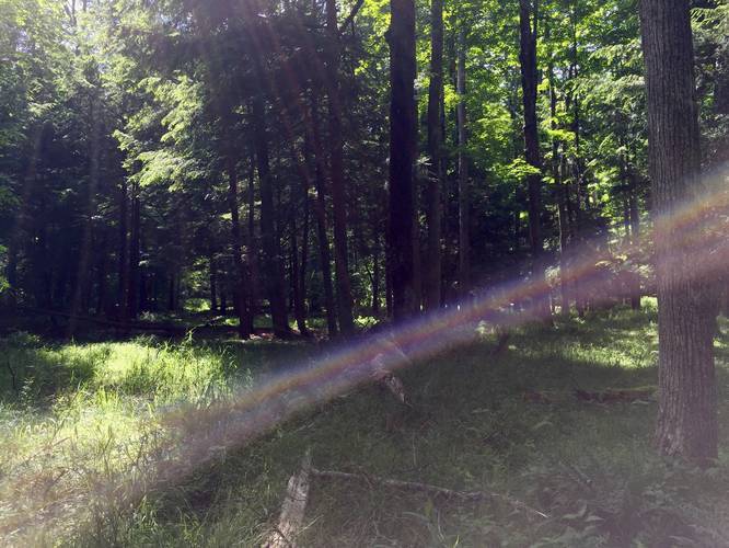
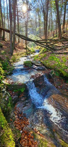
Around 1-mile into the hike the service road finally ends and the true trail begins. Here you'll hike through evergreens and pine trees before coming across a campsite around 1.9-miles in. At the campsite is a small gorge with a creek and small waterfall. Continuing on from the campsite is a new metal bridge you can use to cross the creek.
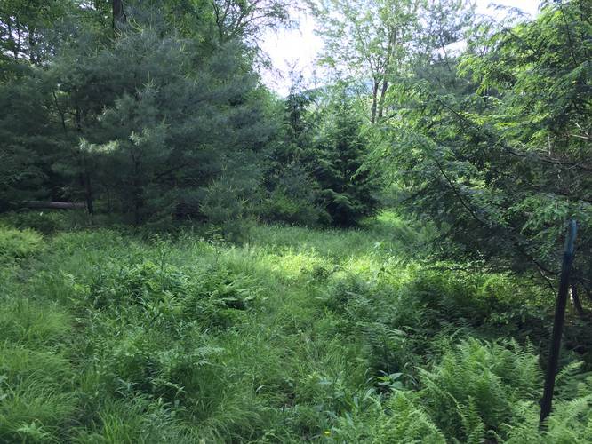
After passing the campsite area, you'll start hiking through the most overgrown section of the trail, during warmer months. Here you may need to wade through tall ferns and tall grass to find the trail on the other side of the overgrowth - this is where a GPS tracking device is extremely useful.
Follow the blue blazes through the overgrowth, over small creeks, and across newly-built wooden footbridges to continue following the Bee Tree Ski Trail.
After roughly 3.3-miles from the eastern trailhead, the trail will take a sharp left-hand turn where it starts to climb the southern mountain and up another gorge area. This section of the trail is where most of the elevation gain lies, but the grade is moderate and the climb lasts for 1.5-miles. Once you reach the top, the trail will cross another creek at a hairpin turn where you'll begin your climb back downhill.
The downhill climb from mile 4.6 to 6.4 (end of the trail) is a nice break from heading uphill, but can be a challenge regardless. The first half-mile or so is fairly flat, so you can catch your breath before heading downhill. You'll eventually reach an area that was logged, so there are downed trees scattered throughout the woods along the sides of the trail.
After passing the logging area, you'll head downhill further for about 0.5-miles to where the trail hits a fork. Here the trail technically continues to the right-hand side - as this GPS shows; however, you can head to the left-hand side to keep your feet more dry and take this connector trail over to the Deadman Hollow Run Trail and out to parking to finish the 6.4-mile trek.
Warning: During the warmer months, there can be plenty of overgrowth along the trail, which makes it difficult to find your way. The blue blazes are old and often very difficult to find, so your best bet is to have an offline-capable tracking device to ensure you're on the right part of the trail. If you head out without a GPS tracker, you could very easily lose the trail during months with a lot of overgrowth.
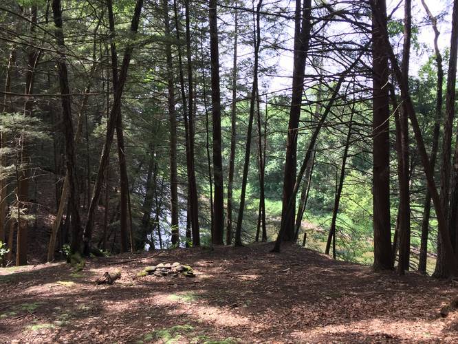
Camping: There's a campsite around 1.9-miles into the hike - if heading east to west. The campsite sits on a hill above Pine Creek with a view of the creek. Adjacent to the campsite is a small creek that flows into Pine Creek below and there's a small 4 to 5-foot tall waterfall that cascades down the creek.
Pets: Dogs are allowed if leashed and their waste must be carried out.
Water source: If you use a water filter, you can filter from various creeks along the way.
Parking: The eastern parking area can be found at the parking coordinates provided; however, there's only space for about 2 cars, maximum. You can also find parking at the western terminus along Freleigh Flat Rd in Gaines, PA at the hairpin turn in the road (41.746190, -77.493285). There are enough spaces for about 4 cars in the lot at the western terminus. The western trailhead parking lot sits adjacent to private property, so please be respectful.
Biking: Mountain biking is allowed on this trail. You may encounter some downed trees from time to time, but the trail is not very rocky or full of roots.
This recording starts at the eastern trailhead and heads west. The eastern-most trailhead can be found along the West Rim Trail, but this short 0.2-mile section has nothing additional to see. The trail immediately heads uphill along a wide service road. The hike uphill ends approximately 0.5-miles into the hike where the trail levels out before heading downhill. The trail is blazed with blue blazes, but they are often difficult to follow once the service road turns into a real backcountry trail.
Before the service road ends and the true backcountry trail begins, you can find nearby mountain peaks through the breaks in the trees. During the winter and colder months when no leaves are on the trees, you can get better views of the surrounding mountains on this section of the trail.
Around 1-mile into the hike the service road finally ends and the true trail begins. Here you'll hike through evergreens and pine trees before coming across a campsite around 1.9-miles in. At the campsite is a small gorge with a creek and small waterfall. Continuing on from the campsite is a new metal bridge you can use to cross the creek.
After passing the campsite area, you'll start hiking through the most overgrown section of the trail, during warmer months. Here you may need to wade through tall ferns and tall grass to find the trail on the other side of the overgrowth - this is where a GPS tracking device is extremely useful.
Follow the blue blazes through the overgrowth, over small creeks, and across newly-built wooden footbridges to continue following the Bee Tree Ski Trail.
After roughly 3.3-miles from the eastern trailhead, the trail will take a sharp left-hand turn where it starts to climb the southern mountain and up another gorge area. This section of the trail is where most of the elevation gain lies, but the grade is moderate and the climb lasts for 1.5-miles. Once you reach the top, the trail will cross another creek at a hairpin turn where you'll begin your climb back downhill.
The downhill climb from mile 4.6 to 6.4 (end of the trail) is a nice break from heading uphill, but can be a challenge regardless. The first half-mile or so is fairly flat, so you can catch your breath before heading downhill. You'll eventually reach an area that was logged, so there are downed trees scattered throughout the woods along the sides of the trail.
After passing the logging area, you'll head downhill further for about 0.5-miles to where the trail hits a fork. Here the trail technically continues to the right-hand side - as this GPS shows; however, you can head to the left-hand side to keep your feet more dry and take this connector trail over to the Deadman Hollow Run Trail and out to parking to finish the 6.4-mile trek.
Warning: During the warmer months, there can be plenty of overgrowth along the trail, which makes it difficult to find your way. The blue blazes are old and often very difficult to find, so your best bet is to have an offline-capable tracking device to ensure you're on the right part of the trail. If you head out without a GPS tracker, you could very easily lose the trail during months with a lot of overgrowth.
Camping: There's a campsite around 1.9-miles into the hike - if heading east to west. The campsite sits on a hill above Pine Creek with a view of the creek. Adjacent to the campsite is a small creek that flows into Pine Creek below and there's a small 4 to 5-foot tall waterfall that cascades down the creek.
Pets: Dogs are allowed if leashed and their waste must be carried out.
Water source: If you use a water filter, you can filter from various creeks along the way.
Parking: The eastern parking area can be found at the parking coordinates provided; however, there's only space for about 2 cars, maximum. You can also find parking at the western terminus along Freleigh Flat Rd in Gaines, PA at the hairpin turn in the road (41.746190, -77.493285). There are enough spaces for about 4 cars in the lot at the western terminus. The western trailhead parking lot sits adjacent to private property, so please be respectful.
Biking: Mountain biking is allowed on this trail. You may encounter some downed trees from time to time, but the trail is not very rocky or full of roots.