Albion Falls and Lover's Leap Trail at Albion Falls Park in Hamilton, Ontario is an easy 0.8 km out-and-back hike that features views of the 19 meter (62.3-foot) tall waterfall, Albion Falls including a view from a cliff known as Lover's Leap.
Trail
This short walk begins at the main parking lot for Albion Falls, located on the east side of Mountain Brow Blvd.
Albion Falls Lookout - 0 km
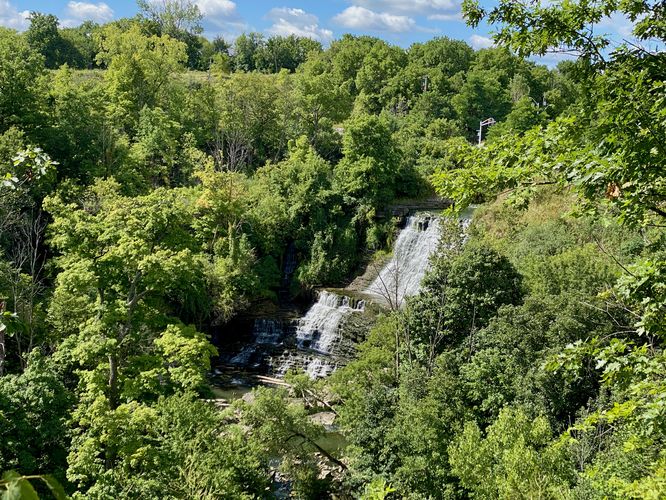
The trail leads directly to one of the best views of Albion Falls, located just a stone's throw from the parking lot. This view of Albion Falls is further away, but provides a view of the entire waterfall no matter what time of the year you visit. Albion Falls cascades down the Niagara Escarpment bedrock at approximately 19 meters (62.3-feet) in two main tiers.
Hike to Lover's Leap - 0 to 0.4 km
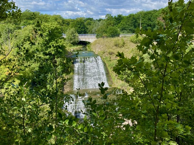
After checking out the first view of Albion Falls, the trail leads west as it runs alongside Mountain Brow Blvd following a sidewalk. You'll pass over Redhill Creek with a view into the gorge where the water slips over the top of Albion Falls. Just on the other side of the bridge, hikers will find a guardrail that separates the road from the trail -- cross to the opposite side of the guardrail to continue along the trail. Hike uphill a bit before the trail reaches an interpretive sign adjacent to the path that leads down to Lover's Leap. Take this trail downhill to reach Lover's Leap around 0.4 km. The view of Albion Falls from Lover's Leap is the closest view hikers will find of the waterfall, but during the summer the view can be a bit overgrown. The best view of the entirety of Albion Falls is likely when some vegetation has fallen off during Autumn. After exploring the views from Lover's Leap, the trail leads back to parking for a short 0.8 km out-and-back hike.
Connection with RBG Rock Garden
Visitors may not know that the Royal Botanical Gardens Rock Garden was built using rocks and boulders from the Albion Falls area. If you wish to explore the Rock Garden you can check out our Rock Garden Accessible Loop or Lower Rock Garden Trail guides.
Popularity
This is a very popular place to visit. During weekends, plan to arrive early or late in the day to beat the crows.
Parking
Hikers will find a large parking lot on the east side of Mountain Brow Blvd at the coordinates provided, in Hamilton Ontario. The lot is large enough to fit over a dozen vehicles as of August 2024.
Pets
Dogs are allowed only if leashed and must be cleaned up after.
Trail
This short walk begins at the main parking lot for Albion Falls, located on the east side of Mountain Brow Blvd.
Albion Falls Lookout - 0 km
The trail leads directly to one of the best views of Albion Falls, located just a stone's throw from the parking lot. This view of Albion Falls is further away, but provides a view of the entire waterfall no matter what time of the year you visit. Albion Falls cascades down the Niagara Escarpment bedrock at approximately 19 meters (62.3-feet) in two main tiers.
Hike to Lover's Leap - 0 to 0.4 km
After checking out the first view of Albion Falls, the trail leads west as it runs alongside Mountain Brow Blvd following a sidewalk. You'll pass over Redhill Creek with a view into the gorge where the water slips over the top of Albion Falls. Just on the other side of the bridge, hikers will find a guardrail that separates the road from the trail -- cross to the opposite side of the guardrail to continue along the trail. Hike uphill a bit before the trail reaches an interpretive sign adjacent to the path that leads down to Lover's Leap. Take this trail downhill to reach Lover's Leap around 0.4 km. The view of Albion Falls from Lover's Leap is the closest view hikers will find of the waterfall, but during the summer the view can be a bit overgrown. The best view of the entirety of Albion Falls is likely when some vegetation has fallen off during Autumn. After exploring the views from Lover's Leap, the trail leads back to parking for a short 0.8 km out-and-back hike.
Connection with RBG Rock Garden
Visitors may not know that the Royal Botanical Gardens Rock Garden was built using rocks and boulders from the Albion Falls area. If you wish to explore the Rock Garden you can check out our Rock Garden Accessible Loop or Lower Rock Garden Trail guides.
Popularity
This is a very popular place to visit. During weekends, plan to arrive early or late in the day to beat the crows.
Parking
Hikers will find a large parking lot on the east side of Mountain Brow Blvd at the coordinates provided, in Hamilton Ontario. The lot is large enough to fit over a dozen vehicles as of August 2024.
Pets
Dogs are allowed only if leashed and must be cleaned up after.