Loading...

WINTER SALE! 50% OFF Supporter Accounts — now through January 31st. Learn More.

Yovimpa Point Trail

The Yovimpa Point Trail at Bryce Canyon National Park near Bryce Canyon City, Utah is an easy 0.3 out-and-back hike that features southern views of Bryce Canyon National Park.

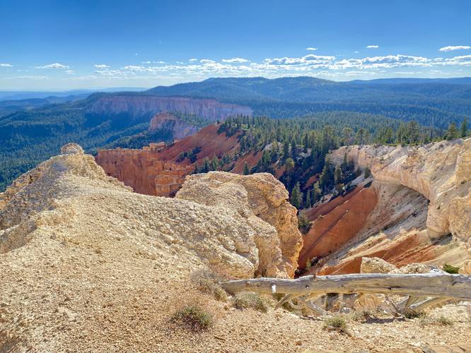
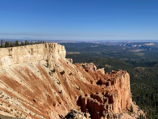
This short woodland trail leads hikers from the main parking lot for Rainbow Point, located on the southeastern corner, and heads through the woods to reach Yovimpa Point. Along the way, the trail dips down into the forest and then back out to the viewpoint with minimal elevation change. From Yovimpa Point, hikers will get views far into the distance, like Navajo Mountain located ~100-miles away or the Pink Cliffs within the Grand Staircase-Escalante National Monument.

Fees
Bryce Canyon National Park has a $35/week entry fee as of September 2023. Visitors are highly encouraged to purchase an annual National Parks pass before their trip to reduce entry fees (especially if you're passing through multiple parks) and to also speed-up the very-long line that leads into the park.

Parking
Visitors will find a large parking lot at the coordinates provided.

Pets
Dogs are not allowed on this trail.
Explore 24 trails near Bryce Canyon City, UT

Know Before You Go

  • Yovimpa Point Trail is an easy, 0.3-mile hike in Bryce Canyon National Park offering southern views, including landmarks like Navajo Mountain and the Pink Cliffs.
  • The trail starts at the Rainbow Point parking lot, leading through a short woodland section to Yovimpa Point with minimal elevation change.
  • Entry to Bryce Canyon National Park requires a fee, with an annual National Parks pass recommended to save money and time.
Interactive topographic map for Yovimpa Point Trail located in Bryce Canyon City, UT. Click the "View Map" button to load GPS coordinates and trail markers.
Get directions
Distance
0.3 mi
Difficulty
Easy
Type
Out-and-Back
Est. Time
9 min
Elev. Gain
38'
Rating
5.0
Added
September 25, 2023
Updated
October 06, 2023

Weather Forecast

Loading...
Total Change
17'
Ascent
38'
Descent
38'
Loading...

Download the GPX Data for Offline Use

Supporters get exclusive access to download trail routes to the MyHikes app for offline use. Stay prepared on your adventure, even without an internet connection! Become a Supporter today to unlock this feature and hike with confidence.

Download Yovimpa Point Trail GPX Data to the MyHikes Mobile App

Features

Vista / Lookout Point

Points of interest

  1. Parking

    37.474693, -112.240318
  2. Main Trailhead

    37.474394, -112.240314

Safety information

For your own safety: plan ahead, let someone know where you'll be, and hike at your own risk.

Hazards

Snakes (Rattlesnakes, Copperheads, others)
Rockfalls, Ledges, or Scrambles

Availability

All seasons

Surface type

Dirt

Trip Reports (Reviews)

Rated 5.0 out of 5 based on 1 rating.

Ready to help fellow hikers? Add a trip report to share your experience and provide valuable insights for other hikers!

0.3 miles / 0.5 km
September 25, 2023
Hiking
No community routes found. To add your own hike as a Community Route for this Trail guide, leave a Trip Report with an attached GPX file.

Popular categories

Scenic mountain view representing vista trails
Vista trails
Scenic gorge of cascades representing waterfall trails
Waterfall hikes
Rugged mountain terrain representing summit trails
Summit trails
Scenic mountain view representing dog-friendly trails
Dog-friendly
Scenic campsite with a view representing camping trails
Camping trails
Appalachian Trail logo representing A.T. hikes
A.T. hikes

You May Also Like

Colorado's Million Dollar Highway - Plan a day's drive adventure along the iconic Million Dollar Highway in Colorado. Explore the best short trails, roadside stops, waterfalls, vistas, ghost towns, and hot springs within a ~6 hour road trip.
Explore

Colorado's Million Dollar Highway

Plan a day's drive adventure along the iconic Million Dollar Highway in Colorado. Explore the best short trails, roadside stops, waterfalls, vistas, ghost towns, and hot springs within a ~6 hour road trip.

Read
Glacier's Going-to-the-Sun Road - Discover the breathtaking beauty of Glacier National Park along the iconic Going-to-the-Sun Road. From stunning roadside stops to picturesque waterfalls and vistas, this engineering marvel offers endless opportunities for exploration.
Explore

Glacier's Going-to-the-Sun Road

Discover the breathtaking beauty of Glacier National Park along the iconic Going-to-the-Sun Road. From stunning roadside stops to picturesque waterfalls and vistas, this engineering marvel offers endless opportunities for exploration.

Read
🍪 We use cookies to learn about site usage and to serve map tiles. You may block cookies manually in the browser. By continuing you agree. Learn more