Loading...

๐ŸŽ‰ Enjoy a Free 7-Day Supporter Trial and Unlock Exclusive Perks โ€” No Credit Card Required. Learn more.

Powell Point Vista

Directions
Map
Pictures
Send to App
Distance:
0.1 Miles / 0.2 km
Type:
Out-and-Back
Difficulty:
Easy
Time to Hike:
~5 minutes
Features:
Surface Type:
Universal Access
Park:
Grand Staircase-Escalante National Monument
Town:
Henrieville, Utah
Directions:
37.639417, -111.844182
Added:
September 26, 2023
Updated:
October 03, 2023
Copy Trail Link Hiking this trail? Send a friend or family member a link to this trail guide for your own safety. Hike at your own risk (disclaimer)
Loading...
Loading...
24'

Total Change
24'

Ascent
24'

Descent

Download the Trail Route for Offline Use

Supporters get exclusive access to download trail routes to the MyHikes app for offline use. Stay prepared on your adventure, even without an internet connection! Become a Supporter today to unlock this feature and hike with confidence.

Send to App

Powell Point Vista

Powell Point Vista at the Grand Staircase-Escalante National Monument near Henrieville, Utah is an easy 0.1-mile out-and-back roadside stop that features views of the Pink Cliffs.

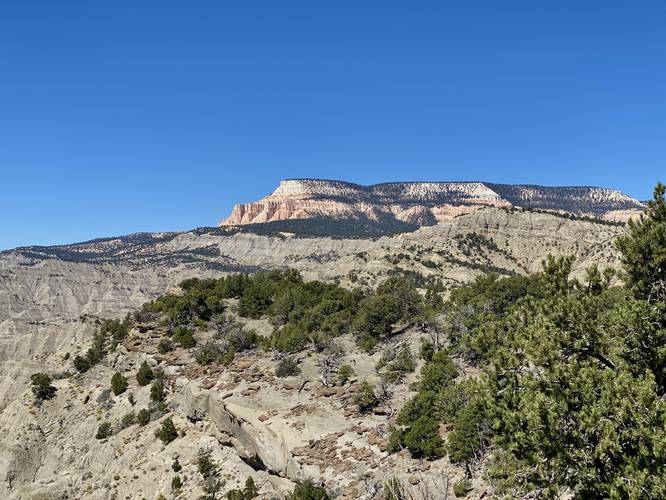
This is not a hike but rather a short universally-accessible walk along a paved path that features views of the Pink Cliffs along with information kiosks. This is a great spot to take a break on a long road trip through Utah. From Power Point, visitors get a view into the topmost layer of the Colorado Plateau's Grand Staircase. This top layer, known as the Pink Cliffs or Claron Formation, is the same geologic layer that forms the spectacular landscape of Bryce Canyon National Park and Red Canyon.

Universal Access
This vista point has a universally-accessible paved path that reaches the viewing area and information kiosks.

Parking
Visitors will find a small parking turnout at the coordinates provided. Across the street is another parking turnout of a similar size. Mind the highway traffic along UT-12.

Pets
Dogs are allowed if leashed and must be cleaned up after.
Explore 28 trails near Henrieville, UT
  1. Parking

    37.639417, -111.844182
  2. Main Trailhead

    37.639467, -111.84421
  3. View of the Pink Cliffs from Powell Point Vista

    37.6395, -111.844406
    View of the Pink Cliffs from Powell Point Vista
No community routes found. To add your own hike as a Community Route for this Trail guide, leave a Trip Report with an attached GPX file.

Hazards

Snakes

Seasons

All

Photo Albums

Trip Reports

Trail Guide By:
Admin user profile picture
0.1 miles / 0.2 km
0.1 miles / 0.2 km
September 26, 2023
Hiking
Preview of the MyHikes mobile app interface

Track, Log, and Explore Hikes with the MyHikes App

Shop Landscape Prints
Shop our landscape prints from popular locations around Utah

Weather Forecast

In Henrieville, UT

Explore Hiking Trails

You May Also Like

Colorado's Million Dollar Highway - Plan a day's drive adventure along the iconic Million Dollar Highway in Colorado. Explore the best short trails, roadside stops, waterfalls, vistas, ghost towns, and hot springs within a ~6 hour road trip.
Explore

Colorado's Million Dollar Highway

Plan a day's drive adventure along the iconic Million Dollar Highway in Colorado. Explore the best short trails, roadside stops, waterfalls, vistas, ghost towns, and hot springs within a ~6 hour road trip.

Read
Glacier's Going-to-the-Sun Road - Discover the breathtaking beauty of Glacier National Park along the iconic Going-to-the-Sun Road. From stunning roadside stops to picturesque waterfalls and vistas, this engineering marvel offers endless opportunities for exploration.
Explore

Glacier's Going-to-the-Sun Road

Discover the breathtaking beauty of Glacier National Park along the iconic Going-to-the-Sun Road. From stunning roadside stops to picturesque waterfalls and vistas, this engineering marvel offers endless opportunities for exploration.

Read
New York's Best Waterfalls - Whether you're planning a day hike, roadside stop, or a leisurely short walk, this guide provides hikers, travelers, and locals alike with 63 different locations to over 100 scenic waterfalls to help plan your next adventure!
Explore

New York's Best Waterfalls

Whether you're planning a day hike, roadside stop, or a leisurely short walk, this guide provides hikers, travelers, and locals alike with 63 different locations to over 100 scenic waterfalls to help plan your next adventure!

Read

Before you boogie...

Find our trail guides useful? Consider becoming a Supporter to unlock perks!

MyHikes is an indie platform that makes exploring public trails easier for everyone. The platform has no investors, no ads, and is owned and operated by one person, Dave Miller. Dave has personally mapped and written over 1,800 trail guides on MyHikes for the public to explore. MyHikes has helped millions outdoor enthusiasts plan their next adventure.

But it takes a lot of time ๐Ÿ•ฆ, money ๐Ÿ’ฐ, work, and espresso shots โ˜• to run MyHikes, including hiking , mapping , writing , and publishing new trails with high-quality (accurate) information... along with software engineering (coding) the platform like building new features, website and mobile app development (iOS and Android), site maintainance . and much much more.

Supporters unlock website and mobile app perks with an annual one-time payment of $25 (you renew) ๐Ÿ˜Ž๐Ÿ‘. Or you can simply make a Donation of your choice. Otherwise, you can support us by telling your friends about MyHikes - both quick and free ๐ŸŽ‰

Admin user profile picture

Dave Miller
MyHikes Founder