Loading...

๐ŸŽ‰ Enjoy a Free 7-Day Supporter Trial and Unlock Exclusive Perks โ€” No Credit Card Required. Learn more.

Wonderland Trail

Directions
Map
Pictures
Send to App
Distance:
1.5 Miles / 2.4 km
Type:
Out-and-Back
Difficulty:
Easy
Time to Hike:
~45 minutes
Features:
Surface Type:
Dirt
Park:
Acadia National Park
Town:
Southwest Harbor, Maine
Directions:
44.233815, -68.320109
Added:
May 14, 2025
Updated:
May 19, 2025
Copy Trail Link Hiking this trail? Send a friend or family member a link to this trail guide for your own safety. Hike at your own risk (disclaimer)
Loading...
Loading...
62'

Total Change
91'

Ascent
100'

Descent

Download the Trail Route for Offline Use

Supporters get exclusive access to download trail routes to the MyHikes app for offline use. Stay prepared on your adventure, even without an internet connection! Become a Supporter today to unlock this feature and hike with confidence.

Send to App

Wonderland Trail

The Wonderland Trail at Acadia National Park near Southwest Harbor, Maine is an easy 1.5-mile out-and-back hike that leads to Maine's scenic coastline and features ocean and mountain views.

Hiking the Wonderland Trail

This hike begins at the main trailhead, located on the south side of Seawall Road just north of the trailhead for the Ship Harbor Trail. The Wonderland Trail is generally a bit quieter than the Ship Harbor Trail as well, so if you're looking for less crowds this is the hike for you.

As you hike east toward the ocean, the path leads through a mostly-flat section of forest that leaves you waiting for the interesting stuff to come into view. Around mile 0.3 from the trailhead, the landscape changes where you'll find lichen covering the sandy forest floor with pine trees filling-in the landscape.

Ocean & Mountain Views - Mile 0.53 to 0.95

Once you reach mile 0.52, the trail presents a little off-shoot path that leads to the ocean. Here, we hiked off-trail a bit to take in the views. From here, until 0.95-miles in the route provided, the trail offers hikers several ways to get off of the trail and out onto the rocky coastline. The trail also loops around the peninsula, so you have your pick of which direction to take. The route provided loops around counter-clockwise where we hiked off-trail and onto the coastal rocks to enjoy the scenery of the ocean. Hiking off-trail here is another great way to escape the crowds if necessary. As you make your way around the loop, you'll find different views like the islands to the south or Cadillac Mountain to the north. You may even find sailboats passing by in the ocean or nearby sounds and channels.

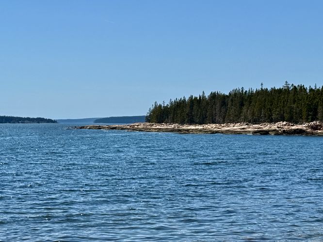
Hiking Out - Mile 0.95 to 1.5

Once you wrap up the loop around the peninsula, the Wonderland Trail leads hikers back to parking via the same route you hiked in on. Follow the trail back through the sandy, pine-filled forest, to reach parking around mile 1.5.

Other Nearby Hikes

To extend your adventure at this part of Acadia National Park, you might want to consider hiking the Ship Harbor Trail or the Flying Mountain Loop.

Parking

Hikers will find parking at the coordinates provided, located on the southeast side of Seawall Road. The parking turnout has enough spaces to fit about 15 vehicles as of May 2025.

Pets

Dogs are allowed only if leashed and must be cleaned up after.
Explore 19 trails near Southwest Harbor, ME
  1. Parking

    44.233815, -68.320109
  2. Main Trailhead

    44.233815, -68.320109
  3. Lichens, pine trees, and sandy forest ecosystem

    44.231422, -68.314369
    Lichens, pine trees, and sandy forest ecosystem
  4. View of the ocean

    44.229361, -68.31305
    View of the ocean
  5. Scenic coastal view of Bennet Cove

    44.229347, -68.312272
    Scenic coastal view of Bennet Cove
  6. View of islands off of the coast

    44.228378, -68.312003
    View of islands off of the coast
  7. View of Cadillac Mountain

    44.227978, -68.310967
    View of Cadillac Mountain
  8. View of Bennet Cove and Cadillac Mountain

    44.228922, -68.311011
    View of Bennet Cove and Cadillac Mountain
No community routes found. To add your own hike as a Community Route for this Trail guide, leave a Trip Report with an attached GPX file.

Hazards

Ticks - Lyme Disease More Info (CDC)
Poison Ivy/Oak

Seasons

All

Blaze Color

Blue

Weather Forecast

In Southwest Harbor, ME

Explore Hiking Trails

You May Also Like

Colorado's Million Dollar Highway - Plan a day's drive adventure along the iconic Million Dollar Highway in Colorado. Explore the best short trails, roadside stops, waterfalls, vistas, ghost towns, and hot springs within a ~6 hour road trip.
Explore

Colorado's Million Dollar Highway

Plan a day's drive adventure along the iconic Million Dollar Highway in Colorado. Explore the best short trails, roadside stops, waterfalls, vistas, ghost towns, and hot springs within a ~6 hour road trip.

Read
Glacier's Going-to-the-Sun Road - Discover the breathtaking beauty of Glacier National Park along the iconic Going-to-the-Sun Road. From stunning roadside stops to picturesque waterfalls and vistas, this engineering marvel offers endless opportunities for exploration.
Explore

Glacier's Going-to-the-Sun Road

Discover the breathtaking beauty of Glacier National Park along the iconic Going-to-the-Sun Road. From stunning roadside stops to picturesque waterfalls and vistas, this engineering marvel offers endless opportunities for exploration.

Read
New York's Best Waterfalls - Whether you're planning a day hike, roadside stop, or a leisurely short walk, this guide provides hikers, travelers, and locals alike with 63 different locations to over 100 scenic waterfalls to help plan your next adventure!
Explore

New York's Best Waterfalls

Whether you're planning a day hike, roadside stop, or a leisurely short walk, this guide provides hikers, travelers, and locals alike with 63 different locations to over 100 scenic waterfalls to help plan your next adventure!

Read

Before you boogie...

Find our trail guides useful? Consider becoming a Supporter to unlock perks!

MyHikes is an indie platform that makes exploring public trails easier for everyone. The platform has no investors, no ads, and is owned and operated by one person, Dave Miller. Dave has personally mapped and written over 1,800 trail guides on MyHikes for the public to explore. MyHikes has helped millions outdoor enthusiasts plan their next adventure.

But it takes a lot of time ๐Ÿ•ฆ, money ๐Ÿ’ฐ, work, and espresso shots โ˜• to run MyHikes, including hiking , mapping , writing , and publishing new trails with high-quality (accurate) information... along with software engineering (coding) the platform like building new features, website and mobile app development (iOS and Android), site maintainance . and much much more.

Supporters unlock website and mobile app perks with an annual one-time payment of $25 (you renew) ๐Ÿ˜Ž๐Ÿ‘. Or you can simply make a Donation of your choice. Otherwise, you can support us by telling your friends about MyHikes - both quick and free ๐ŸŽ‰

Admin user profile picture

Dave Miller
MyHikes Founder