Loading...

WINTER SALE! 50% OFF Supporter Accounts — now through January 31st. Learn More.

Flying Mountain Loop Hike

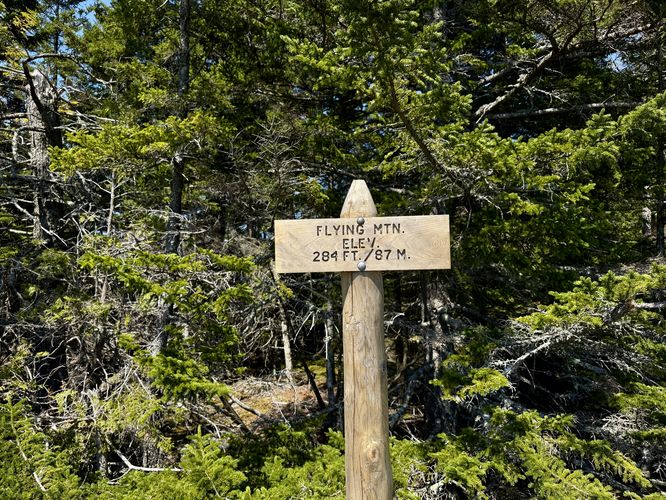
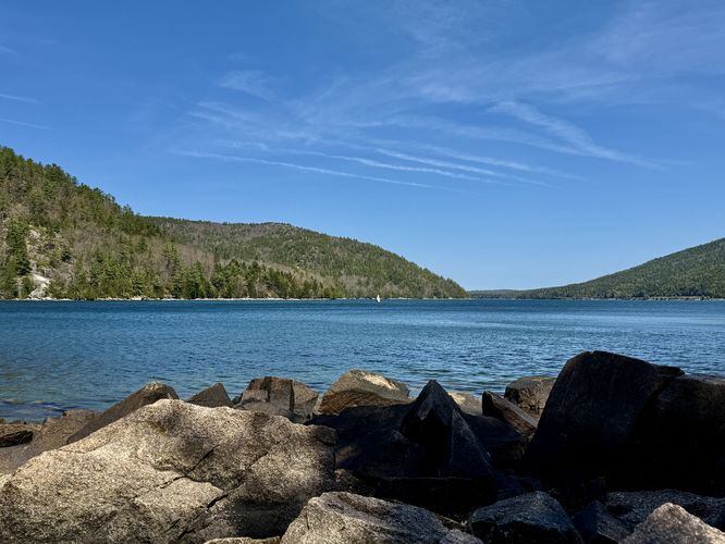
The Flying Mountain Loop at Acadia National Park near Southwest Harbor, Maine is a moderate 1.5-mile hike that summits Flying Mountain and features views of Somes Sound, The Narrows, and Valley Cove.

Hiking Flying Mountain

This hike begins at the main trailhead for Flying Mountain, located near the end of Fernald Point Road at the coordinates provided. The route follows two named trails (Flying Mountain Trail and the Valley Cove Trail) in a counter-clockwise order, starting with the ascent to Flying Mountain's summit first.

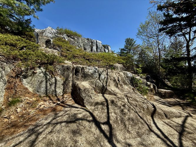
The hike up Flying Mountain should be considered moderate. The trail winds through a pine forest with bedrock and large rocks for steps as the blue blazes define the path. Around mile 0.22, hikers will reach the "rock scramble" that the park lists on their information kiosk map. This short and easy rock scramble might not be easy for everyone, especially little kids, but we found it to be no more than taller rock steps. You should be able to traverse this scramble with ease.

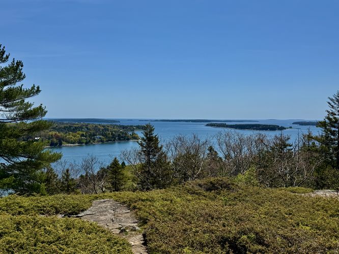
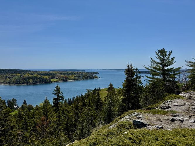
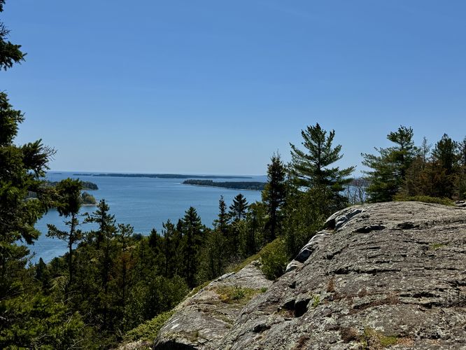
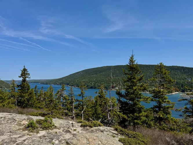
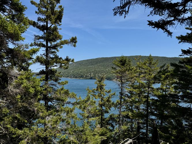
Just beyond the rock scramble are views of Somes Sound to the south with smaller islands dotting the watery landscape below. To the east are views of a channel named The Narrows which bisects Flying Mountain from the town of Mount Desert.

Flying Mountain's Summit - Mile 0.3

Around mile 0.3 sits the summit of Flying Mountain with a sign and two different survey markers from 1934 located right next to each other. You'll also find more views of Somes Sound, Mount Desert, and The Narrows from the summit.

Somes Sound Overlook - Mile 0.57

After exploring the summit, the trail runs north along Flying Mountain's ridge line as it leads out to another overlook on the northeast side of the mountain. Located on the east side of the trail around mile 0.57, off of the main trail, sits the Somes Sound Overlook which provides hikers with northeast views from the mountain of both The Narrows and Somes Sound.

Hiking to Valley Cove Beach - Mile 0.57 to 0.95

After exploring the Somes Sound Overlook from the northeast slopes of Flying Mountain, the trail then traverses the northern slope as it leads downhill along switchbacks to reach Valley Cove below. Along the way are a couple of obstructed view points on-trail. If you aren't staring at your feet the entire way, be on the lookout for more views. Eventually, hikers will reach a small footbridge and off-shoot path that leads to the Valley Cove Beach. This route follows the path onto the beach where we took a short break and enjoyed the views and scenery of Somes Sound and Valley Cove. Here, you'll also notice very tall and prominent cliffs that sit below Saint Sauveur Mountain. These cliffs are home to peregrine falcon who typically nest in the cliffs each year. For their own safety and protection, the trail that runs below the cliffs is usually closed off each Spring to provide the birds with solitude for nesting.

Hiking to Parking - Mile 0.95 to 1.5

The last leg of this hike leads from Valley Cove beach back to the parking lot. Head back to the footbridge to find a trail junction with the Valley Cove Trail. Follow that trail due-south as it leads uphill and then finally follows a "flat" grade through an evergreen forest. Hike the trail until you reach the service road gate at the parking lot to complete this 1.5-mile loop hike.

Parking

Hikers will find a very small parking lot at the coordinates provided, located on the northwest side of Fernald Point Road. The lot is large enough to fit less than 10 vehicles as of May 2025.

Pets

Dogs are allowed only if leashed and must be cleaned up after.
Explore 20 trails near Southwest Harbor, ME

Know Before You Go

  • The Flying Mountain Loop is a 1.5-mile moderate hike in Acadia National Park, offering views of Somes Sound, The Narrows, and Valley Cove.
  • The trail includes a short rock scramble, a summit with survey markers, and an overlook with views of Somes Sound, as well as access to Valley Cove Beach.
  • Parking is limited (less than 10 vehicles), and dogs are allowed on a leash.
Interactive topographic map for Flying Mountain Loop Hike located in Southwest Harbor, ME. Click the "View Map" button to load GPS coordinates and trail markers.
Get directions
Distance
1.5 mi
Difficulty
Moderate
Type
Loop
Est. Time
1 hrs
Elev. Gain
378'
Rating
4.0
Added
May 14, 2025
Updated
May 19, 2025

Weather Forecast

Loading...
Total Change
282'
Ascent
378'
Descent
379'
Loading...

Download the GPX Data for Offline Use

Supporters get exclusive access to download trail routes to the MyHikes app for offline use. Stay prepared on your adventure, even without an internet connection! Become a Supporter today to unlock this feature and hike with confidence.

Download Flying Mountain Loop Hike GPX Data to the MyHikes Mobile App

Features

Vista / Lookout Point
Dogs
Mountain Summit

Points of interest

  1. Parking

    44.299667, -68.316279
  2. Main Trailhead

    44.299667, -68.316279
  3. Easy rock scramble / steps area

    44.301447, -68.314597
    Easy rock scramble / steps area
  4. View of Somes Sound

    44.301739, -68.314589
    View of Somes Sound

Safety information

For your own safety: plan ahead, let someone know where you'll be, and hike at your own risk.

Hazards

Poison Ivy or Poison Oak

Markers

Blaze Color

Blue

Availability

All seasons

Surface type

Dirt

Trip Reports (Reviews)

Rated 4.0 out of 5 based on 1 rating.

Ready to help fellow hikers? Add a trip report to share your experience and provide valuable insights for other hikers!

No community routes found. To add your own hike as a Community Route for this Trail guide, leave a Trip Report with an attached GPX file.

Popular categories

Scenic mountain view representing vista trails
Vista trails
Scenic gorge of cascades representing waterfall trails
Waterfall hikes
Rugged mountain terrain representing summit trails
Summit trails
Scenic mountain view representing dog-friendly trails
Dog-friendly
Scenic campsite with a view representing camping trails
Camping trails
Appalachian Trail logo representing A.T. hikes
A.T. hikes

You May Also Like

Colorado's Million Dollar Highway - Plan a day's drive adventure along the iconic Million Dollar Highway in Colorado. Explore the best short trails, roadside stops, waterfalls, vistas, ghost towns, and hot springs within a ~6 hour road trip.
Explore

Colorado's Million Dollar Highway

Plan a day's drive adventure along the iconic Million Dollar Highway in Colorado. Explore the best short trails, roadside stops, waterfalls, vistas, ghost towns, and hot springs within a ~6 hour road trip.

Read
Glacier's Going-to-the-Sun Road - Discover the breathtaking beauty of Glacier National Park along the iconic Going-to-the-Sun Road. From stunning roadside stops to picturesque waterfalls and vistas, this engineering marvel offers endless opportunities for exploration.
Explore

Glacier's Going-to-the-Sun Road

Discover the breathtaking beauty of Glacier National Park along the iconic Going-to-the-Sun Road. From stunning roadside stops to picturesque waterfalls and vistas, this engineering marvel offers endless opportunities for exploration.

Read
🍪 We use cookies to learn about site usage and to serve map tiles. You may block cookies manually in the browser. By continuing you agree. Learn more