Loading...

WINTER SALE! 50% OFF Supporter Accounts — now through January 31st. Learn More.

Wiggly Bridge & Steedman Woods Loop Trail

The Wiggly Bridge & Steedman Woods loop trail is a 0.7 mile hike that starts and ends on Lilac Lane in York, Maine.

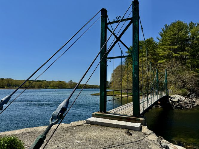
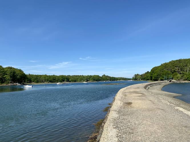
The trail leads across a dam on the York River and leads across the Wiggly Bridge over to Steedman Woods. Great views of the York River, fishing boats in the harbor, and just a nice short hike through the woods along the water.

The trail loops through Steedman Woods with a trailhead found at the end of Mill Dam Road with a small parking lot.

Additional hikes: If you plan to visit this trail, be sure to check out the Fisherman's Walk Trail, just across the street. You can take the Fisherman's Walk over to the Cliff Walk Trail for a longer and even more scenic hike.

Parking: The parking coordinates provided here have about 4 permit-only spots and 3 or 4 non-permit parking spots. The parking lot can fill up quickly, so show up early to get a spot or hike over from the Fisherman's Walk Trail parking area.

Biking: Biking not allowed on the Wiggly Bridge side of the trail. The signs are not 100% clear about biking through the Steedman Woods portion of the trail, but likely not allowed either. Check the Steedman Woods trailhead billboard for more details.

Pets: Dogs are allowed if on leash and their waste must be carried out.
Explore 42 trails near York, ME

Know Before You Go

  • The Wiggly Bridge & Steedman Woods Loop Trail in York, ME is a short, 0.7-mile hike offering scenic views of the York River and harbor, with access from Lilac Lane.
  • The trail features the unique Wiggly Bridge and loops through Steedman Woods, with parking potentially limited; consider arriving early or hiking from the Fisherman's Walk Trail.
  • Biking is prohibited on the Wiggly Bridge side and likely not allowed in Steedman Woods; dogs are permitted on leash with waste carried out.
Interactive topographic map for Wiggly Bridge & Steedman Woods Loop Trail located in York, ME. Click the "View Map" button to load GPS coordinates and trail markers.
Get directions
Distance
0.7 mi
Difficulty
Easy
Type
Loop
Est. Time
21 min
Elev. Gain
74'
Rating
5.0
Added
July 02, 2017
Updated
August 05, 2021

Weather Forecast

Loading...
Total Change
57'
Ascent
74'
Descent
38'
Loading...

Download the GPX Data for Offline Use

Supporters get exclusive access to download trail routes to the MyHikes app for offline use. Stay prepared on your adventure, even without an internet connection! Become a Supporter today to unlock this feature and hike with confidence.

Download Wiggly Bridge & Steedman Woods Loop Trail GPX Data to the MyHikes Mobile App

Features

Vista / Lookout Point
Dogs

Points of interest

  1. Parking

    43.136524, -70.647477
  2. Main Trailhead

    43.136445, -70.647537

Safety information

For your own safety: plan ahead, let someone know where you'll be, and hike at your own risk.

Availability

Summer

Surface type

Dirt

Trip Reports (Reviews)

Rated 5.0 out of 5 based on 1 rating.

Ready to help fellow hikers? Add a trip report to share your experience and provide valuable insights for other hikers!

0.3 miles / 0.5 km
May 12, 2025
Short walk out to the Wiggly Bridge after we took a jaunt on the Fisherman's Walk.
Dogs Hiking
0.7 miles / 1.1 km
May 25, 2021
Quiet morning walk through Steedman Woods. The town seemed to have opened up a couple more non-permit parking spots along the road as well.
Dogs Hiking
0.7 miles / 1.1 km
May 25, 2021
Dogs Hiking
No community routes found. To add your own hike as a Community Route for this Trail guide, leave a Trip Report with an attached GPX file.

Popular categories

Scenic mountain view representing vista trails
Vista trails
Scenic gorge of cascades representing waterfall trails
Waterfall hikes
Rugged mountain terrain representing summit trails
Summit trails
Scenic mountain view representing dog-friendly trails
Dog-friendly
Scenic campsite with a view representing camping trails
Camping trails
Appalachian Trail logo representing A.T. hikes
A.T. hikes

You May Also Like

Colorado's Million Dollar Highway - Plan a day's drive adventure along the iconic Million Dollar Highway in Colorado. Explore the best short trails, roadside stops, waterfalls, vistas, ghost towns, and hot springs within a ~6 hour road trip.
Explore

Colorado's Million Dollar Highway

Plan a day's drive adventure along the iconic Million Dollar Highway in Colorado. Explore the best short trails, roadside stops, waterfalls, vistas, ghost towns, and hot springs within a ~6 hour road trip.

Read
Glacier's Going-to-the-Sun Road - Discover the breathtaking beauty of Glacier National Park along the iconic Going-to-the-Sun Road. From stunning roadside stops to picturesque waterfalls and vistas, this engineering marvel offers endless opportunities for exploration.
Explore

Glacier's Going-to-the-Sun Road

Discover the breathtaking beauty of Glacier National Park along the iconic Going-to-the-Sun Road. From stunning roadside stops to picturesque waterfalls and vistas, this engineering marvel offers endless opportunities for exploration.

Read
🍪 We use cookies to learn about site usage and to serve map tiles. You may block cookies manually in the browser. By continuing you agree. Learn more