Loading...

WINTER SALE! 50% OFF Supporter Accounts — now through January 31st. Learn More.

Fisherman's Walk Trail

Fisherman's Walk is a small 0.8 mile out-and-back trail that leads from the Wiggly Bridge/Steedman Woods Trail over to York Harbor Beach and the Cliff Walk Trail.

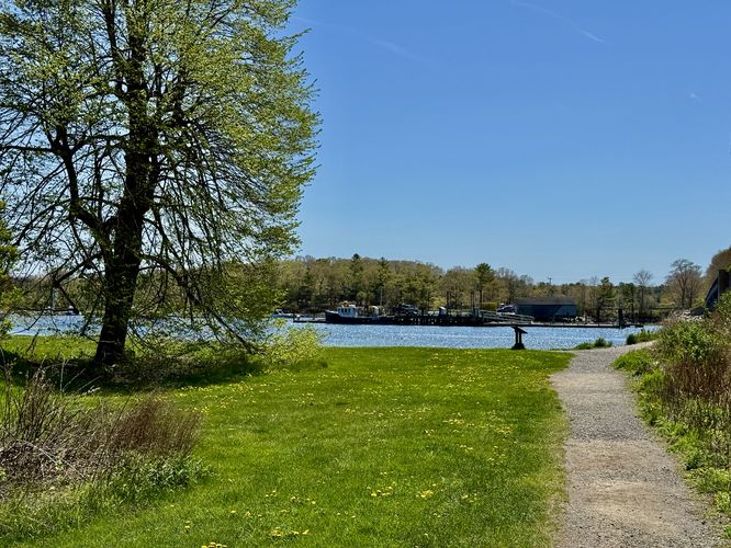
The trail leads along the York River with waterside views. Occasionally the trail crosses a street, so be on the lookout for where the trail continues. Once you make it to the western side of the York Harbor Beach area, you've reached the end.

Additional hikes: If you plan to visit this trail, be sure to check out the Wiggly Bridge Trail, just across the street. You can also link up with the Cliff Walk Trail for a longer and even more scenic hike found after the southeast trailhead along this trail.

Parking: You can park at the same parking area for the Wiggly Bridge and walk over or you can park directly on Barrell Ln Exd Rd. If you plan to park near York Harbor Beach, be sure to read the signs about permit parking along Harbor Beach Road - you're better off parking on York Street.

Pets: Dogs are allowed if on leash and their waste must be carried out. Please note that dogs are not allowed on the Cliff Walk Trail, so if you plan to hit both, do not take your pup.
Explore 42 trails near York, ME

Know Before You Go

  • Fisherman's Walk is a short, 0.8-mile trail in York, ME, offering waterside views along the York River and connecting the Wiggly Bridge Trail to York Harbor Beach and the Cliff Walk Trail.
  • The trail involves street crossings, so awareness is needed to follow the path, and parking is available at Wiggly Bridge or on Barrell Ln Exd Rd, with caution advised regarding permit parking near York Harbor Beach.
  • Dogs are permitted on leash with waste removal required, but they are not allowed on the connecting Cliff Walk Trail.
Interactive topographic map for Fisherman's Walk Trail located in York, ME. Click the "View Map" button to load GPS coordinates and trail markers.
Get directions
Distance
0.8 mi
Difficulty
Easy
Type
Out-and-Back
Est. Time
24 min
Elev. Gain
62'
Rating
4.0
Added
July 02, 2017
Updated
July 09, 2019

Weather Forecast

Loading...
Total Change
45'
Ascent
62'
Descent
63'
Loading...

Download the GPX Data for Offline Use

Supporters get exclusive access to download trail routes to the MyHikes app for offline use. Stay prepared on your adventure, even without an internet connection! Become a Supporter today to unlock this feature and hike with confidence.

Download Fisherman's Walk Trail GPX Data to the MyHikes Mobile App

Features

Vista / Lookout Point
Dogs
Biking

Points of interest

  1. Parking

    43.135062, -70.646276
  2. Main Trailhead

    43.134985, -70.646115

Safety information

For your own safety: plan ahead, let someone know where you'll be, and hike at your own risk.

Availability

Summer

Surface type

Dirt

Trip Reports (Reviews)

Rated 4.0 out of 5 based on 1 rating.

Ready to help fellow hikers? Add a trip report to share your experience and provide valuable insights for other hikers!

0.8 miles / 1.3 km
May 12, 2025
Beautiful day out on the trail. This spot has become more and more popular over the years, but it's fairly quiet on weekdays. We hit up the Wiggly Bridge while we were here.
Dogs Hiking
0.8 miles / 1.3 km
June 07, 2018
Hiking
0.8 miles / 1.3 km
July 03, 2017
Hiking
No community routes found. To add your own hike as a Community Route for this Trail guide, leave a Trip Report with an attached GPX file.

Popular categories

Scenic mountain view representing vista trails
Vista trails
Scenic gorge of cascades representing waterfall trails
Waterfall hikes
Rugged mountain terrain representing summit trails
Summit trails
Scenic mountain view representing dog-friendly trails
Dog-friendly
Scenic campsite with a view representing camping trails
Camping trails
Appalachian Trail logo representing A.T. hikes
A.T. hikes

You May Also Like

Colorado's Million Dollar Highway - Plan a day's drive adventure along the iconic Million Dollar Highway in Colorado. Explore the best short trails, roadside stops, waterfalls, vistas, ghost towns, and hot springs within a ~6 hour road trip.
Explore

Colorado's Million Dollar Highway

Plan a day's drive adventure along the iconic Million Dollar Highway in Colorado. Explore the best short trails, roadside stops, waterfalls, vistas, ghost towns, and hot springs within a ~6 hour road trip.

Read
Glacier's Going-to-the-Sun Road - Discover the breathtaking beauty of Glacier National Park along the iconic Going-to-the-Sun Road. From stunning roadside stops to picturesque waterfalls and vistas, this engineering marvel offers endless opportunities for exploration.
Explore

Glacier's Going-to-the-Sun Road

Discover the breathtaking beauty of Glacier National Park along the iconic Going-to-the-Sun Road. From stunning roadside stops to picturesque waterfalls and vistas, this engineering marvel offers endless opportunities for exploration.

Read
🍪 We use cookies to learn about site usage and to serve map tiles. You may block cookies manually in the browser. By continuing you agree. Learn more