Loading...

WINTER SALE! 50% OFF Supporter Accounts — now through January 31st. Learn More.

Waterrock Knob Hike

Waterrock Knob, the tallest peak in the Plott Balsam Mountains, can be reached via a short summit trail from the scenic Waterrock Knob Overlook. Located at milepost 451.2 on the Blue Ridge Parkway, this stop is located near the southern terminus of the parkway and is typically much less crowded than the popular hikes in the neighboring Great Balsam Mountains. The Waterrock Knob Visitors Center parking lot, denoted the Waterrock Knob Overlook, has outstanding views to the east and west and is a great place to take in a sunrise or sunset. The short but steep Waterrock Knob Trail climbs over 400 feet in half a mile. From the rock outcrops below the summit you’ll have good views south of the Scott Creek Valley, Plott Balsam Mountains, and Cowee Mountains. This short hike is suitable for all ages, but is steep enough to make you feel like you earned the 6,292-foot summit.

While you’re here – If you want to do some more hiking, consider the trail to Yellow Face and Blackrock Mountain. The trailhead is located at the intersection of the Blue Ridge Parkway and Waterrock Knob Rd

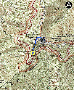
  • Mile 0.0 – Park at the Waterrock Knob Visitors Center. The massive parking lot at an elevation at 5,820 feet actually provides better views than the summit 400+ feet above, so you’ll want to spend a little time walking around the perimeter. The western side of the parking lot provides panoramic views of the Great Smoky Mountains. The eastern side of the lot provides views of the Scott Creek Valley dividing the Plott Balsams from the Great Balsam Mountains. Due south Yellow Face rises to the right of a smaller knob. Waterrock Knob and Browning Knob rise immediately above the parking lot to the north.

    To begin the hike, follow the Waterrock Knob Trail at the north end of the parking lot. Immediately you’ll meet the Mountains-to-Sea Trail [440] (white blaze) heading east on the right . The Mountains-to-Sea Trail briefly follows the Waterrock Knob Trail along a paved path.

  • Mile 0.2 – Y-junction with the Mountains-to-Sea Trail on the left heading west. The paved path soon ends as the trail now climbs along a rough, dirt path.

  • Mile 0.5 – At a right curve there is a nice view east of Plott Balsam on the left and Mt. Lyn Lowry on the right. An unmarked trail turns left at a Y-junction. The main trail keeps right ascending stone steps to the summit.

  • Mile 0.55 – The trail passes over the summit of Waterrock Knob (6,292 feet), the highest peak in the Plott Balsam Mountains and 13th highest peak in the Eastern United States. Immediately after the true summit the trail ends at a series of rock outcrops with southern views. The headwaters of North Fork Scott Creek begin directly below the summit. The parkway winds around the Plott Balsam Mountains to the east, with the high peaks of the Great Balsam Mountains rising high above Scott Creek and Balsam Gap.

  • Mile 1.0 – Hike ends at the Waterrock Knob Visitors Center parking lot.

By HikingUpward Contributor: Zach Robbins
Explore 29 trails near Sylva, NC

Know Before You Go

  • Waterrock Knob Trail is a short but steep 1-mile hike to the tallest peak in the Plott Balsam Mountains, offering panoramic views from the summit and the Waterrock Knob Overlook parking lot.
  • Located at milepost 451.2 on the Blue Ridge Parkway near its southern terminus, Waterrock Knob is less crowded than other popular hikes in the area and provides opportunities for sunrise and sunset viewing.
  • The trail, though challenging with over 400 feet of elevation gain, is suitable for all ages and offers views of the Scott Creek Valley, Plott Balsam Mountains, and Cowee Mountains from rock outcrops near the summit; plus, there is an option to hike to Yellow Face and Blackrock Mountain nearby.
Interactive topographic map for Waterrock Knob Hike located in Sylva, NC. Click the "View Map" button to load GPS coordinates and trail markers.
Get directions
Distance
1.0 mi
Difficulty
Moderate
Type
Out-and-Back
Est. Time
30 min
Elev. Gain
502'
Rating
4.0
Added
April 03, 2025
Updated
April 06, 2025

Weather Forecast

Loading...
Total Change
449'
Ascent
502'
Descent
502'
Loading...

Download the GPX Data for Offline Use

Supporters get exclusive access to download trail routes to the MyHikes app for offline use. Stay prepared on your adventure, even without an internet connection! Become a Supporter today to unlock this feature and hike with confidence.

Download Waterrock Knob Hike GPX Data to the MyHikes Mobile App

Features

Vista / Lookout Point
Dogs
Mountain Summit

Points of interest

  1. Parking

    35.45985, -83.140762
  2. Main Trailhead

    35.460112, -83.140454

Safety information

For your own safety: plan ahead, let someone know where you'll be, and hike at your own risk.

Hazards

Snakes (Rattlesnakes, Copperheads, others)
Poison Ivy or Poison Oak

Availability

All seasons

Surface type

Dirt

Trip Reports (Reviews)

Rated 4.0 out of 5 based on 1 rating.

Ready to help fellow hikers? Add a trip report to share your experience and provide valuable insights for other hikers!

By: Brent
1.0 mile / 1.6 km
November 10, 2019
Great short but steep hike/climb...can be muddy
Legacy Review
No community routes found. To add your own hike as a Community Route for this Trail guide, leave a Trip Report with an attached GPX file.

Popular categories

Scenic mountain view representing vista trails
Vista trails
Scenic gorge of cascades representing waterfall trails
Waterfall hikes
Rugged mountain terrain representing summit trails
Summit trails
Scenic mountain view representing dog-friendly trails
Dog-friendly
Scenic campsite with a view representing camping trails
Camping trails
Appalachian Trail logo representing A.T. hikes
A.T. hikes

You May Also Like

25 Best Day Hikes in North Carolina - Discover the top 25 best day hikes in North Carolina, from breathtaking waterfalls to mountain peaks. Explore hidden gems, scenic views, and trails suitable for all skill levels, perfect for your next outdoor adventure.
Explore

25 Best Day Hikes in North Carolina

Discover the top 25 best day hikes in North Carolina, from breathtaking waterfalls to mountain peaks. Explore hidden gems, scenic views, and trails suitable for all skill levels, perfect for your next outdoor adventure.

Read
Colorado's Million Dollar Highway - Plan a day's drive adventure along the iconic Million Dollar Highway in Colorado. Explore the best short trails, roadside stops, waterfalls, vistas, ghost towns, and hot springs within a ~6 hour road trip.
Explore

Colorado's Million Dollar Highway

Plan a day's drive adventure along the iconic Million Dollar Highway in Colorado. Explore the best short trails, roadside stops, waterfalls, vistas, ghost towns, and hot springs within a ~6 hour road trip.

Read
Glacier's Going-to-the-Sun Road - Discover the breathtaking beauty of Glacier National Park along the iconic Going-to-the-Sun Road. From stunning roadside stops to picturesque waterfalls and vistas, this engineering marvel offers endless opportunities for exploration.
Explore

Glacier's Going-to-the-Sun Road

Discover the breathtaking beauty of Glacier National Park along the iconic Going-to-the-Sun Road. From stunning roadside stops to picturesque waterfalls and vistas, this engineering marvel offers endless opportunities for exploration.

Read
🍪 We use cookies to learn about site usage and to serve map tiles. You may block cookies manually in the browser. By continuing you agree. Learn more