The Waihee Ridge Trail in Wailuku, Hawaii is a difficult 4.4-mile out-and-back trail that features breathtaking vistas of the West Maui Mountains, massive waterfalls, and ascends the summit of Lanilili. This trail is by far one of the best hikes on Maui, but is also one of the most popular.
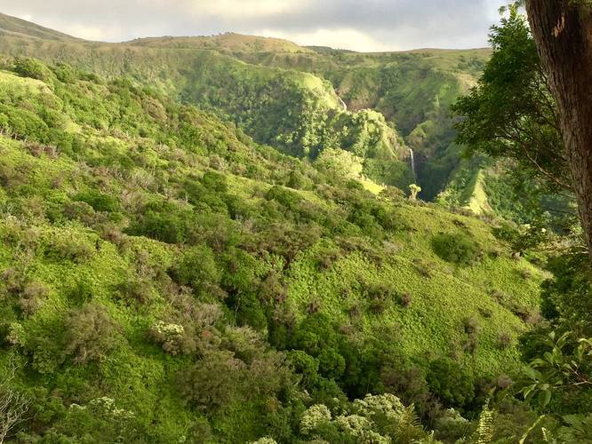
The trail begins at the main parking lot and follows a very steep service road uphill towards a set of water tanks. At the water tanks, the trail turns left at the trail sign and heads into the woods. While hiking through the woods, you'll pass both tropical and coniferous plants before ascending to the first lookout point with a stunning view of Upper Makamaka'ole Falls (13-Crossings Trail).
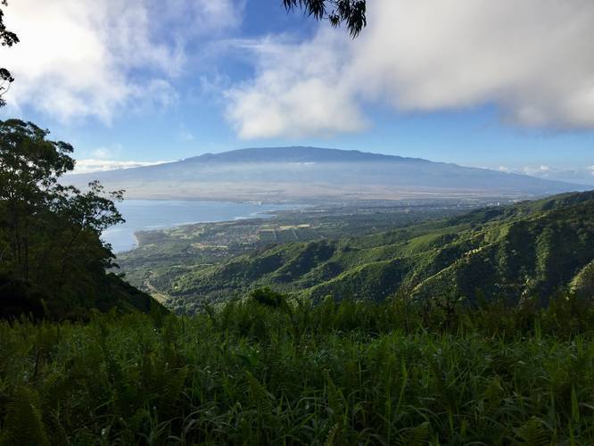
Just after the first lookout point of Upper Makamaka'ole Falls (13-Crossings Trail), you'll reach one of the best vista points along the hike. The viewing platform at the second vista is large enough to hold a couple groups of hikers and gives views of Haleakala, the north-central Maui towns, and breathtaking views into the West Maui Mountains. In the distance, nestled within the mountains, is an enormous waterfall that cascades down the mountainside for hundreds and hundreds of feet. It's hard to tell how tall the waterfall is, but an estimated guess is at least 500-feet.
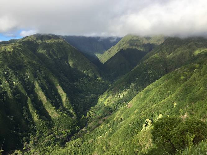
After visiting the second vista point, the trail will continue uphill along countless switchbacks with stunning views along the way. About a half-mile from the second vista point is an area where the ridge trail truly becomes a ridge hike where to each side of the trail are massive drop-offs, within about 8-feet to each side. For those who are afraid of heights, it's worth noting that this section does not last long.
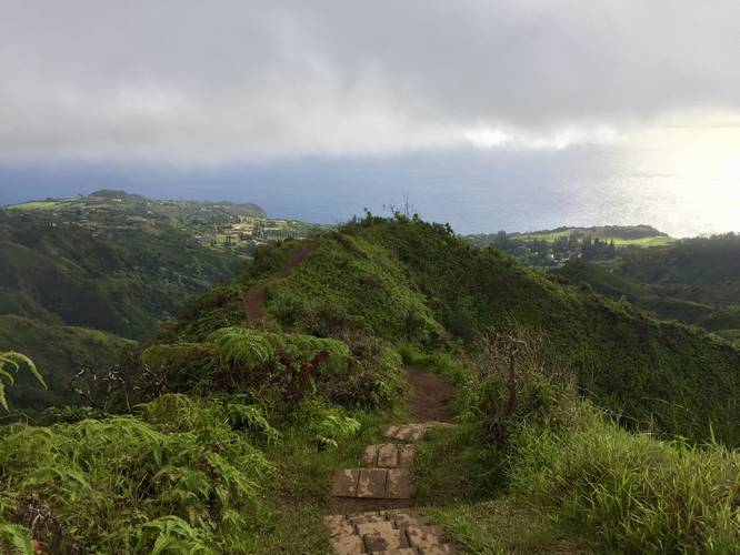
Shortly after the trail runs along the thin ridge section of the trail, you'll hike up into another wooded forest, just before the last climb to the summit. Take your breath here and enjoy the flat hike as you make your way to the last of the switchbacks up to the summit, Lanilili. The switchbacks aren't too difficult and there are about four of them before you'll reach a meandering section of the trail that finally reaches the summit.
Once at the summit, you'll find another large vista platform and a picnic table for resting. The views from the summit can be stunning, if the clouds hold out for you; however, the clouds move quickly and change constantly, so there's no guarantee you'll get a view from the summit.
Hiking back down to parking is a lot faster than hiking up, but the footing can be difficult in places, so take your time and pace yourself - your knees will thank you later.
Hours: The trail is open from 7AM - 7PM daily and there's a gate the blocks vehicles from entering before 7AM. Make sure to leave before 7PM or the gate will automatically close and lock you in.
Views: Along the hike are a multitude of vista points. Primarily, within the first 1-mile of the hike are the best views the trail has to offer, so if you don't want to hike to the summit, you really don't have to. The views from the summit can be hit or miss depending on the clouds. Clouds can roll in quick and roll out quick or they can roll in quick and hang around the summit and mountain valleys - blocking your view. On this hike, we did not get any views from the summit, but had views almost the entire way to the top. Additionally, this mountain valley is also a popular helicopter touring spot, so you'll likely see multiple helicopters flying in and around the mountains during your hike.
Parking: Parking can be found at the coordinates provided; however, an overflow parking lot can be found 0.8-miles down the hill next to the first gate. If you're unlucky and show up late, you may need to park in the overflow lot which will add an additional 1.6-miles out-and-back to this already difficult 4.4-mile trek.
Facilities: The only facilities available are a couple of portable toilets near the trailhead. There is no potable water available at the trailhead or at the parking lots, so come prepared with at least 1 liter of water per person if you plan to hike in the early morning or evening. If you plan to hike in mid-day, good luck, and bring at least 2 liters of water per person.
Recommendations: It's best to show up as early as you can to make sure you can grab a parking space next to the trailhead. The lot basically fills up by 9AM, even on a Monday, so the earlier, the better. Also bring proper footwear because the trail can be slick and has some rocky areas. Heading back downhill along a slick trail requires boots or shoes with a good grip to them. Do not hike this trail in flip-flops like I've seen elsewhere on Maui.
Pets: Dogs are allowed if leashed and their waste must be carried out.
Warning: This trail runs along massive cliffs along the ridge to reach the summit. Stay on the trail at all times and hike at your own risk.
Prohibited: Horses, biking, and ATVs are all prohibited on this trail.
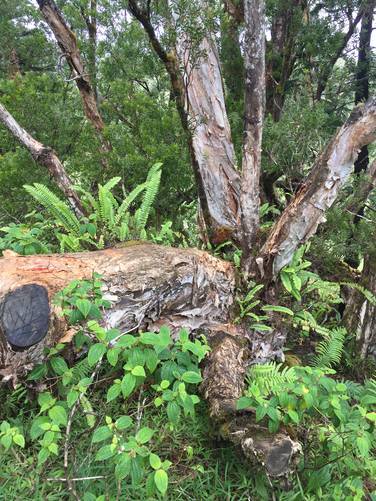
Eucalyptus Trees: You can find eucalyptus trees in two different spots along the hike - in between the 1st and 2nd lookout points and around mile 1.6. The trees located between the 1st and 2nd lookout points are younger trees while the trees found around mile 1.6 are much older. None of them are the 'rainbow' eucalyptus trees, but they smell amazing regardless.
Respecting the Land
Hawaiian land is considered sacred to native Hawaiians and many locals, so please stay on-trail, take nothing but photos, and leave nothing but footprints. Respect the locals - don't stay for long and have a backup hike planned in case the parking lot is full.
The trail begins at the main parking lot and follows a very steep service road uphill towards a set of water tanks. At the water tanks, the trail turns left at the trail sign and heads into the woods. While hiking through the woods, you'll pass both tropical and coniferous plants before ascending to the first lookout point with a stunning view of Upper Makamaka'ole Falls (13-Crossings Trail).
Just after the first lookout point of Upper Makamaka'ole Falls (13-Crossings Trail), you'll reach one of the best vista points along the hike. The viewing platform at the second vista is large enough to hold a couple groups of hikers and gives views of Haleakala, the north-central Maui towns, and breathtaking views into the West Maui Mountains. In the distance, nestled within the mountains, is an enormous waterfall that cascades down the mountainside for hundreds and hundreds of feet. It's hard to tell how tall the waterfall is, but an estimated guess is at least 500-feet.
After visiting the second vista point, the trail will continue uphill along countless switchbacks with stunning views along the way. About a half-mile from the second vista point is an area where the ridge trail truly becomes a ridge hike where to each side of the trail are massive drop-offs, within about 8-feet to each side. For those who are afraid of heights, it's worth noting that this section does not last long.
Shortly after the trail runs along the thin ridge section of the trail, you'll hike up into another wooded forest, just before the last climb to the summit. Take your breath here and enjoy the flat hike as you make your way to the last of the switchbacks up to the summit, Lanilili. The switchbacks aren't too difficult and there are about four of them before you'll reach a meandering section of the trail that finally reaches the summit.
Once at the summit, you'll find another large vista platform and a picnic table for resting. The views from the summit can be stunning, if the clouds hold out for you; however, the clouds move quickly and change constantly, so there's no guarantee you'll get a view from the summit.
Hiking back down to parking is a lot faster than hiking up, but the footing can be difficult in places, so take your time and pace yourself - your knees will thank you later.
Hours: The trail is open from 7AM - 7PM daily and there's a gate the blocks vehicles from entering before 7AM. Make sure to leave before 7PM or the gate will automatically close and lock you in.
Views: Along the hike are a multitude of vista points. Primarily, within the first 1-mile of the hike are the best views the trail has to offer, so if you don't want to hike to the summit, you really don't have to. The views from the summit can be hit or miss depending on the clouds. Clouds can roll in quick and roll out quick or they can roll in quick and hang around the summit and mountain valleys - blocking your view. On this hike, we did not get any views from the summit, but had views almost the entire way to the top. Additionally, this mountain valley is also a popular helicopter touring spot, so you'll likely see multiple helicopters flying in and around the mountains during your hike.
Parking: Parking can be found at the coordinates provided; however, an overflow parking lot can be found 0.8-miles down the hill next to the first gate. If you're unlucky and show up late, you may need to park in the overflow lot which will add an additional 1.6-miles out-and-back to this already difficult 4.4-mile trek.
Facilities: The only facilities available are a couple of portable toilets near the trailhead. There is no potable water available at the trailhead or at the parking lots, so come prepared with at least 1 liter of water per person if you plan to hike in the early morning or evening. If you plan to hike in mid-day, good luck, and bring at least 2 liters of water per person.
Recommendations: It's best to show up as early as you can to make sure you can grab a parking space next to the trailhead. The lot basically fills up by 9AM, even on a Monday, so the earlier, the better. Also bring proper footwear because the trail can be slick and has some rocky areas. Heading back downhill along a slick trail requires boots or shoes with a good grip to them. Do not hike this trail in flip-flops like I've seen elsewhere on Maui.
Pets: Dogs are allowed if leashed and their waste must be carried out.
Warning: This trail runs along massive cliffs along the ridge to reach the summit. Stay on the trail at all times and hike at your own risk.
Prohibited: Horses, biking, and ATVs are all prohibited on this trail.
Eucalyptus Trees: You can find eucalyptus trees in two different spots along the hike - in between the 1st and 2nd lookout points and around mile 1.6. The trees located between the 1st and 2nd lookout points are younger trees while the trees found around mile 1.6 are much older. None of them are the 'rainbow' eucalyptus trees, but they smell amazing regardless.
Respecting the Land
Hawaiian land is considered sacred to native Hawaiians and many locals, so please stay on-trail, take nothing but photos, and leave nothing but footprints. Respect the locals - don't stay for long and have a backup hike planned in case the parking lot is full.