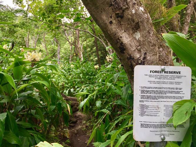
The Makamaka'ole Falls Trail, aka 13 Crossings Trail, at the West Maui Forest Reserve in Wailuku, Hawaii is a moderate 2 mile out-and-back hike up to Makamaka'ole Falls. An additional neat feature along this trail is a dense bamboo forest that you get to hike through and a banyan tree waiting on the other side.
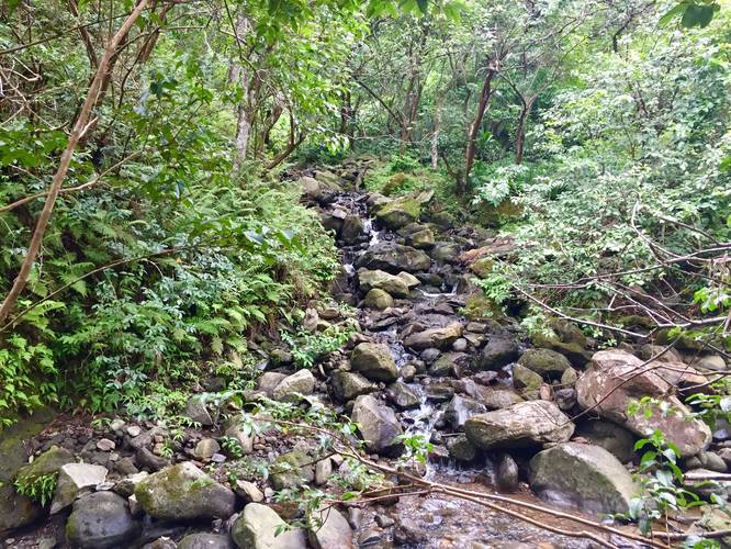
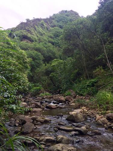
The hike is lightly-trafficked and you'll hike across Makamaka'ole Stream numerous times to finally reach the waterfall, hence the 13 Crossings name. The trail is often very narrow, so you'll brush up against plenty of wet tropical plants as you make your way through this lush jungle of a forest on your way to the falls.
This trail is rated at moderate because of the terrain and multitude of stream crossings, which are often not very easy. It's highly recommended that you wear water shoes, water boots, or plan to get your feet soaked in order to play it safe on this trail. It's best if you plan to hike through the creek instead of hopping from rock to rock to cross each crossing. Common sense says that when rocks are wet, they're also very slippery - there's no exception on this trail. I personally (Admin) got injured on this trail and had a short trip to the ER after a fall on rocks in the creek. So, with that said, trekking poles, water shoes, and patience are all recommended - plain old hiking boots may not be enough for this one.
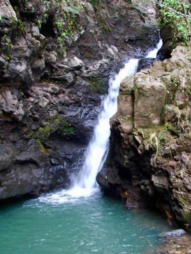
Makamaka'ole Falls: The waterfall can be found about 0.9-miles into the hike. At mile 0.9 you'll reach a fork in the stream - take a right-hand turn here to continue to Makamaka'ole Falls. The waterfall can be found about 0.1-miles away from the fork. Alternatively, for better and less dangerous views of Makamaka'ole Falls, you can hike the Waihee Ridge Trail and get stunning views of the upper cascades - not just the lower cascade. The view point allows you to see Makamaka'ole Falls about a quarter-mile away or so, which is just close enough to enjoy it without having to hike the creek.
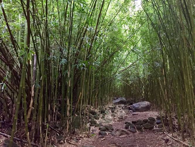
Bamboo Forest: About half-way to Makamaka'ole Falls is an amazing bamboo forest with huge bamboo shoots. This is quite the sight if you've never hiked through a bamboo forest before, but this section of bamboo does not last for long - only a few hundred feet.
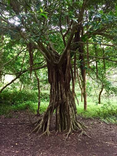
Banyan tree: Just after the bamboo forest, heading toward the falls, you'll pass a really cool banyan tree.
Guava trees and fruit: Throughout the hike you may find guava fruit littered along the trail. These yellow or green-rind fruit have a pink inside that resembles an orange.
Flooding & Dangers: This trail lies within an area of Maui that generally gets a decent amount of rainfall. Heavy rains upstream can trigger flash floods that sweep down this creek, so watch the weather and do not hike this trail if there are heavy rains in the weather forecast. Do not attempt to cross the creek if it's running high and the flow is strong to reduce risk of injury or drowning.
What to bring: Hikers should bring at least 1-liter of water per person. Also bring bug spray to try and ward off the mosquitoes. As stated above, proper footwear is a must-have and trekking poles should seriously be considered to help with stream crossings.
Pets: Dogs are allowed if on leash and their waste must be carried out. Please note that this trail may not be suitable for dogs regardless of the forest's regulations. This trail can be dangerous for people and thus can be dangerous for dogs too.
Respecting the Land
Hawaiian land is considered sacred to native Hawaiians and many locals, so please stay on-trail, take nothing but photos, and leave nothing but footprints. Respect the locals - don't stay for long and have a backup hike planned in case the parking lot is full.
The hike is lightly-trafficked and you'll hike across Makamaka'ole Stream numerous times to finally reach the waterfall, hence the 13 Crossings name. The trail is often very narrow, so you'll brush up against plenty of wet tropical plants as you make your way through this lush jungle of a forest on your way to the falls.
This trail is rated at moderate because of the terrain and multitude of stream crossings, which are often not very easy. It's highly recommended that you wear water shoes, water boots, or plan to get your feet soaked in order to play it safe on this trail. It's best if you plan to hike through the creek instead of hopping from rock to rock to cross each crossing. Common sense says that when rocks are wet, they're also very slippery - there's no exception on this trail. I personally (Admin) got injured on this trail and had a short trip to the ER after a fall on rocks in the creek. So, with that said, trekking poles, water shoes, and patience are all recommended - plain old hiking boots may not be enough for this one.
Makamaka'ole Falls: The waterfall can be found about 0.9-miles into the hike. At mile 0.9 you'll reach a fork in the stream - take a right-hand turn here to continue to Makamaka'ole Falls. The waterfall can be found about 0.1-miles away from the fork. Alternatively, for better and less dangerous views of Makamaka'ole Falls, you can hike the Waihee Ridge Trail and get stunning views of the upper cascades - not just the lower cascade. The view point allows you to see Makamaka'ole Falls about a quarter-mile away or so, which is just close enough to enjoy it without having to hike the creek.
Bamboo Forest: About half-way to Makamaka'ole Falls is an amazing bamboo forest with huge bamboo shoots. This is quite the sight if you've never hiked through a bamboo forest before, but this section of bamboo does not last for long - only a few hundred feet.
Banyan tree: Just after the bamboo forest, heading toward the falls, you'll pass a really cool banyan tree.
Guava trees and fruit: Throughout the hike you may find guava fruit littered along the trail. These yellow or green-rind fruit have a pink inside that resembles an orange.
Flooding & Dangers: This trail lies within an area of Maui that generally gets a decent amount of rainfall. Heavy rains upstream can trigger flash floods that sweep down this creek, so watch the weather and do not hike this trail if there are heavy rains in the weather forecast. Do not attempt to cross the creek if it's running high and the flow is strong to reduce risk of injury or drowning.
What to bring: Hikers should bring at least 1-liter of water per person. Also bring bug spray to try and ward off the mosquitoes. As stated above, proper footwear is a must-have and trekking poles should seriously be considered to help with stream crossings.
Pets: Dogs are allowed if on leash and their waste must be carried out. Please note that this trail may not be suitable for dogs regardless of the forest's regulations. This trail can be dangerous for people and thus can be dangerous for dogs too.
Respecting the Land
Hawaiian land is considered sacred to native Hawaiians and many locals, so please stay on-trail, take nothing but photos, and leave nothing but footprints. Respect the locals - don't stay for long and have a backup hike planned in case the parking lot is full.