Loading...

❄️ WINTER SALE! 50% OFF on Supporter Accounts — now through January 31st. Unlock a full year of exclusive website & app perks. Learn More.

Upper Rock Run Falls

Upper Rock Run Falls at the McIntyre Wild Area near McIntyre Township, Pennsylvania is a moderate 0.2-mile out-and-back trail that leads to the 
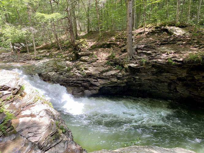
beautiful 10-foot tall rockslide waterfall, Upper Rock Run Falls.

The trail begins by following a fairly steep hillside down to a fishing game commission A-frame cabin. From here, the trail becomes flat as it makes its way out to Upper Rock Run Falls, which is only about 200-feet from the cabin.

At the waterfall, hikers will find several rock ledges above Rock Run, so hiking further downstream may have opportunities for climbing or bouldering above the creek. The waterfall itself is a beautiful cascade, approximately 10-feet tall, that spills into a pool of green-ish blue water below.

Pets
Dogs area allowed if leashed and their waste must be carried out.

Parking
Hikers will find a large parking lot at the coordinates provided - large enough to fit about twelve vehicles.

Swimming
This is the most popular swimming hole along Rock Run. Expect a crowd on weekends and show up early. For another beautiful rockslide waterfall, check out Middle Rock Run Falls. For a more quiet swimming experience, check out Lower Rock Run Falls.
Explore 167 trails near McIntyre Township, PA

Know Before You Go

  • Upper Rock Run Falls is a 10-foot rockslide waterfall accessible via a moderate 0.2-mile out-and-back trail in McIntyre Wild Area, PA.
  • The trail descends to an A-frame cabin before flattening out to reach the falls, offering potential for bouldering upstream.
  • The falls are a popular swimming spot, especially on weekends, with alternative, quieter options available at Lower Rock Run Falls.
Interactive topographic map for Upper Rock Run Falls located in McIntyre Township, PA. Click the "View Map" button to load GPS coordinates and trail markers.
Get directions
Distance
0.2 mi
Difficulty
Moderate
Type
Out-and-Back
Est. Time
6 min
Elev. Gain
68'
Rating
5.0
Added
June 13, 2020
Updated
June 13, 2020

Weather Forecast

Loading...
Total Change
68'
Ascent
68'
Descent
68'
Loading...

Download the GPX Data for Offline Use

Supporters get exclusive access to download trail routes to the MyHikes app for offline use. Stay prepared on your adventure, even without an internet connection! Become a Supporter today to unlock this feature and hike with confidence.

Download Upper Rock Run Falls GPX Data to the MyHikes Mobile App

Features

Dogs
Waterfalls
Water Source
PA Wilds logo PA Wilds

Points of interest

  1. Parking

    41.521767, -76.907845
  2. Main Trailhead

    41.521733, -76.907713

Safety information

For your own safety: plan ahead, let someone know where you'll be, and hike at your own risk.

Availability

All seasons

Surface type

Dirt

Trip Reports (Reviews)

Rated 5.0 out of 5 based on 1 rating.

Ready to help fellow hikers? Add a trip report to share your experience and provide valuable insights for other hikers!

4.4 miles / 7.1 km
October 18, 2025
Climbed mountain (off-trail straight up) just before sunrise for amazing view over Lycoming Valley with Fall foliage colors near peak! Got to enjoy a rainbow as sun came out with a little rain! Once back down, drove up & hiked down to both middle & upper falls of Rock Run (1 of 2 most beautiful streams in all of PA that I love visiting). A big Bald Eagle was perched on a tree above the falls - such a fascinating & unexpected encounter being so close!
Hiking
0.2 miles / 0.3 km
October 08, 2022
Been here in all seasons, and each time has been amazing! Other than Stony Fork Creek, my favorite PA stream - just beautiful beyond words! Did the cold jump into the water from the rocks before, saw the falls frozen, and with peak Fall foliage. I like the Middle Falls a bit better than upper.
Hiking

Explore other routes for this Trail guide, added by the MyHikes' community via Trip Reports (Reviews). To add your own hike as a Community Route for this Trail guide, leave a Trip Report and attached your GPX file!

Popular categories

Scenic mountain view representing vista trails
Vista trails
Scenic gorge of cascades representing waterfall trails
Waterfall hikes
Rugged mountain terrain representing summit trails
Summit trails
Scenic mountain view representing dog-friendly trails
Dog-friendly
Scenic campsite with a view representing camping trails
Camping trails
Appalachian Trail logo representing A.T. hikes
A.T. hikes

You May Also Like

New York's Best Waterfalls - Whether you're planning a day hike, roadside stop, or a leisurely short walk, this guide provides hikers, travelers, and locals alike with 63 different locations to over 100 scenic waterfalls to help plan your next adventure!
Explore

New York's Best Waterfalls

Whether you're planning a day hike, roadside stop, or a leisurely short walk, this guide provides hikers, travelers, and locals alike with 63 different locations to over 100 scenic waterfalls to help plan your next adventure!

Read
🍪 We use cookies to learn about site usage and to serve map tiles. You may block cookies manually in the browser. By continuing you agree. Learn more