Loading...

🎆 50% off 4th of July sale on Supporter Accounts — now through July 6! Learn More.

Middle Rock Run Falls

Directions
Map
Pictures
Send to App
Distance:
0.2 Miles / 0.3 km
Type:
Out-and-Back
Difficulty:
Easy
Time to Hike:
~6 minutes
Features:
PA Wilds
Surface Type:
Dirt
Park:
McIntyre Wild Area
Town:
McIntyre Township, Pennsylvania
Directions:
41.517084, -76.913839
Added:
June 13, 2020
Updated:
June 13, 2020
Copy Trail Link Hiking this trail? Send a friend or family member a link to this trail guide for your own safety. Hike at your own risk (disclaimer)
Loading...
Loading...
38'

Total Change
38'

Ascent
37'

Descent

Download the Trail Route for Offline Use

Supporters get exclusive access to download trail routes to the MyHikes app for offline use. Stay prepared on your adventure, even without an internet connection! Become a Supporter today to unlock this feature and hike with confidence.

Send to App

Middle Rock Run Falls

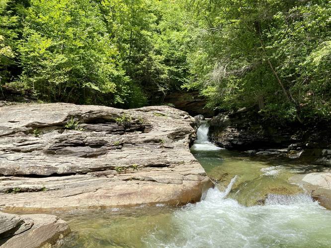
Middle Rock Run Falls at the McIntyre Wild Area near McIntyre Township, Pennsylvania is an easy 0.2-mile out-and-back trail that leads to the beautiful 7-foot tall rockslide waterfall, Middle Rock Run Falls.

This unique waterfall has carved a skinny cascade through the bedrock in the middle of Rock Run creek. The trail basically ends at the waterfall, but hikers can head downstream further than this recording to get better photos of the waterfall. There are several rock ledges nearby that boulderers also use for climbing above the pools of water along Rock Run.

Pets
Dogs area allowed if leashed and their waste must be carried out.

Parking
Hikers will find a large parking lot at the coordinates provided - large enough to fit about ten vehicles.

Swimming
This is one of the most popular swimming holes along Rock Run, however, not as popular as Upper Rock Run Falls. Expect a crowd on weekends. Another, more quiet, swimming hole can be found nearby at Lower Rock Run Falls. Swim and hike at your own risk.
Explore 165 trails near McIntyre Township, PA
  1. Parking

    41.517084, -76.913839
  2. Main Trailhead

    41.517124, -76.913854
  3. Middle Rock Run Falls

    41.517161, -76.912894
    Middle Rock Run Falls
No community routes found. To add your own hike as a Community Route for this Trail guide, leave a Trip Report with an attached GPX file.

Hazards

Ticks - Lyme Disease More Info (CDC)

Seasons

All

Photo Albums

Trip Reports

Trail Guide By:
Admin user profile picture
0.2 miles / 0.3 km
0.2 miles / 0.3 km
June 17, 2021
Some of the most beautiful blue water you'll ever see in PA (besides Stony Fork Creek)! I've seen lots of fish swimming in the deep pool below the falls here too. I like Middle better than Upper & Lower Falls. Perfect for a summer bday trip, and have also seen with peak Fall foliage, and in snow/ice during Winter.
Hiking
0.2 miles / 0.3 km
June 13, 2020
Dogs Hiking

Weather Forecast

In McIntyre Township, PA

Explore Hiking Trails

You May Also Like

Colorado's Million Dollar Highway - Plan a day's drive adventure along the iconic Million Dollar Highway in Colorado. Explore the best short trails, roadside stops, waterfalls, vistas, ghost towns, and hot springs within a ~6 hour road trip.
Explore

Colorado's Million Dollar Highway

Plan a day's drive adventure along the iconic Million Dollar Highway in Colorado. Explore the best short trails, roadside stops, waterfalls, vistas, ghost towns, and hot springs within a ~6 hour road trip.

Read
New York's Best Waterfalls - Whether you're planning a day hike, roadside stop, or a leisurely short walk, this guide provides hikers, travelers, and locals alike with 63 different locations to over 100 scenic waterfalls to help plan your next adventure!
Explore

New York's Best Waterfalls

Whether you're planning a day hike, roadside stop, or a leisurely short walk, this guide provides hikers, travelers, and locals alike with 63 different locations to over 100 scenic waterfalls to help plan your next adventure!

Read

Before you boogie...

Find our trail guides useful? Consider becoming a Supporter to unlock perks!

MyHikes is an indie platform that makes exploring public trails easier for everyone. The platform has no investors, no ads, and is owned and operated by one person, Dave Miller. Dave has personally mapped and written over 1,800 trail guides on MyHikes for the public to explore. MyHikes has helped millions outdoor enthusiasts plan their next adventure.

But it takes a lot of time 🕦, money 💰, work, and espresso shots ☕ to run MyHikes, including hiking , mapping , writing , and publishing new trails with high-quality (accurate) information... along with software engineering (coding) the platform like building new features, website and mobile app development (iOS and Android), site maintainance . and much much more.

Supporters unlock website and mobile app perks with an annual one-time payment of $25 (you renew) 😎👍. Or you can simply make a Donation of your choice. Otherwise, you can support us by telling your friends about MyHikes - both quick and free 🎉

Admin user profile picture

Dave Miller
MyHikes Founder