Tumbling Run Falls at Tioga State Forest near Cedar Run, Pennsylvania is an easy 0.2-mile out-and-back off-trail bushwhack hike that leads to the 13-foot tall, 25-foot long Tumbling Run Falls.
Private Leased Camp
Note that Tumbling Run Falls sits along a creek behind a private 99-year lease camp. Please be respectful of the lease owners and stay off of their property, despite it being public land - do not walk down their driveway and instead follow this hike description to go around the property.
Hike Description
This hike begins just south of Tumbling Run along Leetonia Road, about 100-feet south of the private camp that sits along the creek. As of March 26, 2023, there's a ribbon tied to a tree that indicates a way into the forest, where the bushwhack starts (see my pictures). Head up the steep hill from the road and into the forest. Hike toward the nearest hill and try to stay away from the private camp - which is easy to spot through the forest. Eventually you'll hike to an old logging grade trail that leads up the mountain adjacent to Tumbling Run - hike up this trail for 100-feet or so. Eventually Tumbling Run Falls will come into view before mile 0.1 - hike down the hill to reach the waterfall.
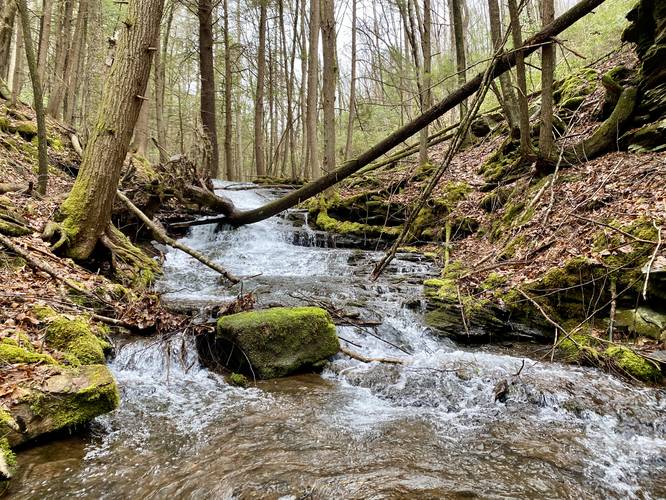
Tumbling Run Falls, 13-feet tall, 25-feet long - Mile 0.1
At mile 0.1, hikers will reach Tumbling Run Falls which cascades down the bedrock of the creek at about 13-feet tall and 25-feet long, hence the name. This waterfall, albeit not very tall, is a scenic cascade that's worth the quick hike. You can hike alongside the waterfall to get a different perspective - or hike to the top to look down at the milky white water sliding down the bedrock. Note that this waterfall is different from the Tumbling Run Falls in SGL 268 near Morris, Pennsylvania.
Parking
Hikers will find a parking turnout located near the coordinates provided, just south of Tumbling Run, on the east side of Leetonia Road. The turnout is large enough for a couple of vehicles.
Pets
Dogs are allowed if leashed and cleaned up after.
Warning
Steep terrain: Around the waterfall is some sloping and steeper terrain that requires a bit of funky maneuvering if you wish to view the waterfall from its base. Watch your footing and take it slow when getting closer to the steeper banks of the creek.
Private Leased Camp
Note that Tumbling Run Falls sits along a creek behind a private 99-year lease camp. Please be respectful of the lease owners and stay off of their property, despite it being public land - do not walk down their driveway and instead follow this hike description to go around the property.
Hike Description
This hike begins just south of Tumbling Run along Leetonia Road, about 100-feet south of the private camp that sits along the creek. As of March 26, 2023, there's a ribbon tied to a tree that indicates a way into the forest, where the bushwhack starts (see my pictures). Head up the steep hill from the road and into the forest. Hike toward the nearest hill and try to stay away from the private camp - which is easy to spot through the forest. Eventually you'll hike to an old logging grade trail that leads up the mountain adjacent to Tumbling Run - hike up this trail for 100-feet or so. Eventually Tumbling Run Falls will come into view before mile 0.1 - hike down the hill to reach the waterfall.
Tumbling Run Falls, 13-feet tall, 25-feet long - Mile 0.1
At mile 0.1, hikers will reach Tumbling Run Falls which cascades down the bedrock of the creek at about 13-feet tall and 25-feet long, hence the name. This waterfall, albeit not very tall, is a scenic cascade that's worth the quick hike. You can hike alongside the waterfall to get a different perspective - or hike to the top to look down at the milky white water sliding down the bedrock. Note that this waterfall is different from the Tumbling Run Falls in SGL 268 near Morris, Pennsylvania.
Parking
Hikers will find a parking turnout located near the coordinates provided, just south of Tumbling Run, on the east side of Leetonia Road. The turnout is large enough for a couple of vehicles.
Pets
Dogs are allowed if leashed and cleaned up after.
Warning
Steep terrain: Around the waterfall is some sloping and steeper terrain that requires a bit of funky maneuvering if you wish to view the waterfall from its base. Watch your footing and take it slow when getting closer to the steeper banks of the creek.