Loading...

WINTER SALE! 50% OFF Supporter Accounts — now through January 31st. Learn More.

Toms Creek Falls Hike

Toms Creek Falls is an outstanding waterfall hidden away north of Marion on the outskirts of Pisgah National Forest. The handicap-accessible Falls Branch Trail (regular wheelchairs may not be suitable) follows Toms Creek for less than a half-mile to the base of the waterfall. You’ll be greeted by Toms Creek Falls, a multilevel cascade over sheer rock walls of a narrow box canyon. It is one of the most scenic and accessible waterfalls in the region.

If you’re looking for a full day hike in the vicinity, we suggest the Bald Knob and Dobson Knob hike only a few miles to the east.

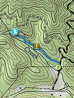
  • Mile 0.0 – Parking is available at the trailhead on Huskins Branch Road. Follow the Falls Branch Trail beside Toms Creek.

  • Mile 0.2 – Cross a wooden bridge over a tributary.

  • Mile 0.4 – The trail splits with a handicap-accessible observation deck on the left and stairs on the right leading closer to the base of the falls. Take the stairs, the observation deck does not provide the best view.

    The height and box canyon walls of Toms Creek Falls will likely surprise you considering the flat creek and trail that originates at the parking area. Toms Creek Falls is a multilevel waterfall between 60-70 feet in height surrounded by sheer cliffs. Even with low water this is an impressive sight. You can safely move around the base of the falls, but attempting to climb it or get a vantage point from the top could result in serious injury, so don’t bother.

  • Mile 0.8 – Hike ends at the parking area
By HikingUpward Contributor: Zach Robbins
Explore 41 trails near Marion, NC

Know Before You Go

  • Toms Creek Falls is a scenic and easily accessible waterfall near Marion, NC, featuring a multilevel cascade within a narrow box canyon.
  • The 0.8-mile Falls Branch Trail is mostly flat and includes handicap-accessible options, though the observation deck doesn't offer the best view compared to the stairs leading to the base of the falls.
  • Climbing the waterfall or attempting to view it from the top is dangerous and not recommended.
Interactive topographic map for Toms Creek Falls Hike located in Marion, NC. Click the "View Map" button to load GPS coordinates and trail markers.
Get directions
Distance
0.8 mi
Difficulty
Easy
Type
Out-and-Back
Est. Time
24 min
Elev. Gain
253'
Rating
0.0
Added
March 13, 2025
Updated
April 05, 2025

Weather Forecast

Loading...
Total Change
185'
Ascent
253'
Descent
253'
Loading...

Download the GPX Data for Offline Use

Supporters get exclusive access to download trail routes to the MyHikes app for offline use. Stay prepared on your adventure, even without an internet connection! Become a Supporter today to unlock this feature and hike with confidence.

Download Toms Creek Falls Hike GPX Data to the MyHikes Mobile App

Features

Dogs
Waterfalls
Water Source

Points of interest

  1. Parking

    35.774347, -82.056852
  2. Main Trailhead

    35.774347, -82.056852

Safety information

For your own safety: plan ahead, let someone know where you'll be, and hike at your own risk.

Hazards

Snakes (Rattlesnakes, Copperheads, others)
Poison Ivy or Poison Oak

Availability

All seasons

Surface type

Dirt

Trip Reports (Reviews)

Your opinion matters! Be the first to rate this trail.

Ready to help fellow hikers? Add a trip report to share your experience and provide valuable insights for other hikers!

No community routes found. To add your own hike as a Community Route for this Trail guide, leave a Trip Report with an attached GPX file.

Popular categories

Scenic mountain view representing vista trails
Vista trails
Scenic gorge of cascades representing waterfall trails
Waterfall hikes
Rugged mountain terrain representing summit trails
Summit trails
Scenic mountain view representing dog-friendly trails
Dog-friendly
Scenic campsite with a view representing camping trails
Camping trails
Appalachian Trail logo representing A.T. hikes
A.T. hikes

You May Also Like

25 Best Day Hikes in North Carolina - Discover the top 25 best day hikes in North Carolina, from breathtaking waterfalls to mountain peaks. Explore hidden gems, scenic views, and trails suitable for all skill levels, perfect for your next outdoor adventure.
Explore

25 Best Day Hikes in North Carolina

Discover the top 25 best day hikes in North Carolina, from breathtaking waterfalls to mountain peaks. Explore hidden gems, scenic views, and trails suitable for all skill levels, perfect for your next outdoor adventure.

Read
Colorado's Million Dollar Highway - Plan a day's drive adventure along the iconic Million Dollar Highway in Colorado. Explore the best short trails, roadside stops, waterfalls, vistas, ghost towns, and hot springs within a ~6 hour road trip.
Explore

Colorado's Million Dollar Highway

Plan a day's drive adventure along the iconic Million Dollar Highway in Colorado. Explore the best short trails, roadside stops, waterfalls, vistas, ghost towns, and hot springs within a ~6 hour road trip.

Read
Glacier's Going-to-the-Sun Road - Discover the breathtaking beauty of Glacier National Park along the iconic Going-to-the-Sun Road. From stunning roadside stops to picturesque waterfalls and vistas, this engineering marvel offers endless opportunities for exploration.
Explore

Glacier's Going-to-the-Sun Road

Discover the breathtaking beauty of Glacier National Park along the iconic Going-to-the-Sun Road. From stunning roadside stops to picturesque waterfalls and vistas, this engineering marvel offers endless opportunities for exploration.

Read
🍪 We use cookies to learn about site usage and to serve map tiles. You may block cookies manually in the browser. By continuing you agree. Learn more