The Thousand Steps Trail at Ravensburg State Park near Jersey Shore, Pennsylvania is a strenuous 0.6-mile out-and-back trail that leads straight up a rock-filled path along a steep mountainside with some seasonal off-trail views and passes into Tiadaghton State Forest where it ends.
Trails
This hike follows one named trail: Thousand Steps Trail. There's another trail in Pennsylvania - the Thousand Steps Trail near Mapleton, PA; however, despite the short mileage, I would argue this trail is much more difficult because it lacks real steps like the other trail. This trail follows a few steps, but it mostly follows rock fields that lead up the mountain.
Hike Description
This trail begins near the southern end of Ravensburg State Park and immediately heads up the steep rocky mountain, first by following a short set of rock stairs before the real ascent begins. As of early March 2022, the trail has a small sign at the start of the staircase labeled "Most Difficult", which was not wrong.
The trail continues straight up the mountain, but the staircase quickly ends as medium-sized and smaller rocks begin the rest of the mountain ascent. As hikers ascend the mountain, they may find that they need to use their hands to ensure better grip and footing along the way up. These rocks do not end until near the very end of the trail.
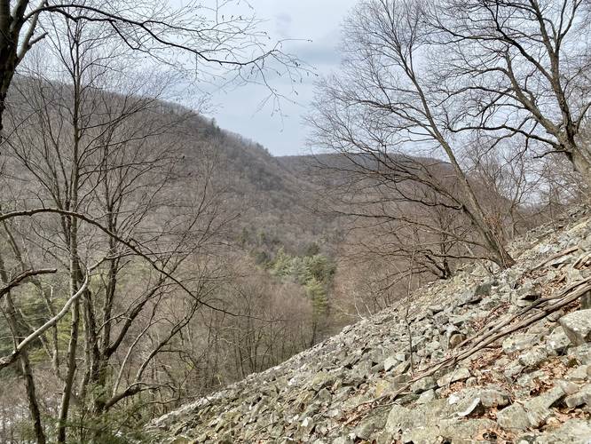
Off-Trail Vista - Mile 0.11
Located just off-trail is a nice view that includes nearby mountain views, but also shows the sheer steepness of the mountainside as well. This off-trail vista can be found around mile 0.11 and may be best during colder months when there are no leaves on the trees. Hikers should be cautious to walk to this vista as the rocks that lead over to it are much smaller, and thus could cause an ankle to roll.
Trail Ends - Mile 0.3
Finally, the trail will escape most of the rocky terrain just before it ends. When it ends, it hits a junction with the Mid State Trail where hikers can make a loop or decide to hike back as an out-and-back, as we did this hike.
Hiking Down
The hike down the Thousand Steps Trail is far trickier than the hike up. The key here is to go slow, watch every step, and use your hands to keep low profile to the ground whenever the terrain becomes a bit too steep. The hike down took much longer than the hike up and it takes a mental toll just figuring out where to traverse the path on the way.
Difficulty
This trail is strenuous as it heads straight up a mountainside while also requiring some light rock scrambling along the way.
Warnings
Winter hiking: During the winter, hikers must bring ice spikes or hiking crampons to ensure proper footing, otherwise, the hikers could easily tumble down the mountainside without any grip.
Wet rocks: It's unwise to attempt to hike this trail after its rained or when the rocks are wet as hikers must scramble up and down rocks almost the entire way.
Steep terrain: This trail follows very steep terrain - some of the steepest terrain in all of Pennsylvania. Going slow is key to ensuring a safe hike.
Rock scrambles: This trail has some light rock scrambling to ensure a safer hike.
Blaze Colors
As of March 2022, this trail follows yellow blazes. These blazes are seldomly placed, but there were enough to easily follow the trail.
Trails
This hike follows one named trail: Thousand Steps Trail. There's another trail in Pennsylvania - the Thousand Steps Trail near Mapleton, PA; however, despite the short mileage, I would argue this trail is much more difficult because it lacks real steps like the other trail. This trail follows a few steps, but it mostly follows rock fields that lead up the mountain.
Hike Description
This trail begins near the southern end of Ravensburg State Park and immediately heads up the steep rocky mountain, first by following a short set of rock stairs before the real ascent begins. As of early March 2022, the trail has a small sign at the start of the staircase labeled "Most Difficult", which was not wrong.
The trail continues straight up the mountain, but the staircase quickly ends as medium-sized and smaller rocks begin the rest of the mountain ascent. As hikers ascend the mountain, they may find that they need to use their hands to ensure better grip and footing along the way up. These rocks do not end until near the very end of the trail.
Off-Trail Vista - Mile 0.11
Located just off-trail is a nice view that includes nearby mountain views, but also shows the sheer steepness of the mountainside as well. This off-trail vista can be found around mile 0.11 and may be best during colder months when there are no leaves on the trees. Hikers should be cautious to walk to this vista as the rocks that lead over to it are much smaller, and thus could cause an ankle to roll.
Trail Ends - Mile 0.3
Finally, the trail will escape most of the rocky terrain just before it ends. When it ends, it hits a junction with the Mid State Trail where hikers can make a loop or decide to hike back as an out-and-back, as we did this hike.
Hiking Down
The hike down the Thousand Steps Trail is far trickier than the hike up. The key here is to go slow, watch every step, and use your hands to keep low profile to the ground whenever the terrain becomes a bit too steep. The hike down took much longer than the hike up and it takes a mental toll just figuring out where to traverse the path on the way.
Difficulty
This trail is strenuous as it heads straight up a mountainside while also requiring some light rock scrambling along the way.
Warnings
Winter hiking: During the winter, hikers must bring ice spikes or hiking crampons to ensure proper footing, otherwise, the hikers could easily tumble down the mountainside without any grip.
Wet rocks: It's unwise to attempt to hike this trail after its rained or when the rocks are wet as hikers must scramble up and down rocks almost the entire way.
Steep terrain: This trail follows very steep terrain - some of the steepest terrain in all of Pennsylvania. Going slow is key to ensuring a safe hike.
Rock scrambles: This trail has some light rock scrambling to ensure a safer hike.
Blaze Colors
As of March 2022, this trail follows yellow blazes. These blazes are seldomly placed, but there were enough to easily follow the trail.