This section of the Sylvan Ridge Trail at Boyce Mayview Park in Upper Saint Clair, Pennsylvania is an easy 0.4-mile one-way trail that connects the Queen Maple Trail to the Switchback Trail and leads to a point-of-interest called Earth Spirit Point.
Hike Description
This track begins along the Sylvan Ridge Trail, south of the Queen Maple Trail’s eastern terminus. The entire Sylvan Ridge Trail extends for about a half-mile heading south from this point, but we did not include that section of the trail in this GPS data.
The trail is flat and follows a well-beaten forest floor littered with pine needles. At the northern end of this trail is the Switchback Trail that leads downhill toward the larger waterfall at the park, which can be found along the Mid-Falls Trail.
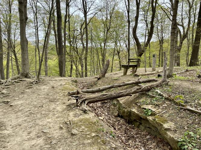
Earth Spirit Point
At the northern terminus, where the trail connects with the Switchback Trail, is a point-of-interest labeled Earth Spirit Point. There were no signs for this POI, but there was a large “scar” cut out in the earth, built up with what looked like small rock walls. This cut in the earth is no larger than 6-feet long and 2-feet wide. I assume this is what Earth Spirit Point is, or maybe it’s simply a reference to what potentially used to be a vista or overlook here as there's an obstructed view through the trees.
Pets
Dogs are allowed on this trail.
Parking
Hikers will find parking at the coordinates provided along Birds Meadow Drive, right off of Boyce Road in Upper St. Clair. The parking lot is large enough to fit about a dozen vehicles.
Biking
Biking is allowed along this trail.
Wildflowers
During the Spring (approx. mid-April) this trail usually has some nice wildflowers like Trout Lily and Trillium.
Connecting Trails
This trail connects with the Queen Maple Trail and the Switchback Trail.
Blaze Color
This trail follows wooden posts with white caps on them, hence white blazes.
Hike Description
This track begins along the Sylvan Ridge Trail, south of the Queen Maple Trail’s eastern terminus. The entire Sylvan Ridge Trail extends for about a half-mile heading south from this point, but we did not include that section of the trail in this GPS data.
The trail is flat and follows a well-beaten forest floor littered with pine needles. At the northern end of this trail is the Switchback Trail that leads downhill toward the larger waterfall at the park, which can be found along the Mid-Falls Trail.
Earth Spirit Point
At the northern terminus, where the trail connects with the Switchback Trail, is a point-of-interest labeled Earth Spirit Point. There were no signs for this POI, but there was a large “scar” cut out in the earth, built up with what looked like small rock walls. This cut in the earth is no larger than 6-feet long and 2-feet wide. I assume this is what Earth Spirit Point is, or maybe it’s simply a reference to what potentially used to be a vista or overlook here as there's an obstructed view through the trees.
Pets
Dogs are allowed on this trail.
Parking
Hikers will find parking at the coordinates provided along Birds Meadow Drive, right off of Boyce Road in Upper St. Clair. The parking lot is large enough to fit about a dozen vehicles.
Biking
Biking is allowed along this trail.
Wildflowers
During the Spring (approx. mid-April) this trail usually has some nice wildflowers like Trout Lily and Trillium.
Connecting Trails
This trail connects with the Queen Maple Trail and the Switchback Trail.
Blaze Color
This trail follows wooden posts with white caps on them, hence white blazes.