The Queen Maple Trail at Boyce Mayview Park in Upper Saint Clair, Pennsylvania is a difficult 0.25-mile one-way trail that features some old growth trees and large rocks along the trail named Vision Rocks.
Hike Description
This hike begins at the western trailhead, located along the Birds Meadow Drive, and heads uphill, climbing the entire way to reach the opposite end of this trail. The trail immediately crosses a small footbridge before heading up a skinny path that heads up the hill. Along the way, hikers will pass some old growth trees which tower over the trail.
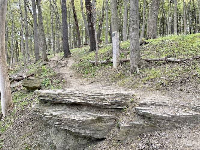
Vision Rocks
Around mile 0.15 hikers will reach the point-of-interest called Vision Rocks which is just a section of large boulders that stick out from the trail. Hikers will also find an obstructed view through the trees at Vision Rocks.
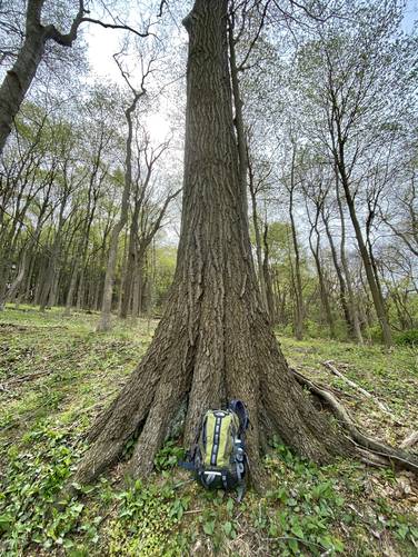
Old Growth Trees
Along this trail are at least a couple of old growth trees. One tree I photographed with my backpack at the base - I believe this is an old growth Maple, hence the trail name.
Pets
Dogs are allowed on this trail.
Parking
Hikers will find parking at the coordinates provided along Birds Meadow Drive, right off of Boyce Road in Upper St. Clair. The parking lot is large enough to fit about a dozen vehicles.
Biking
Biking is not allowed along this trail.
Wildflowers
During the Spring (approx. mid-April) this trail usually has some nice wildflowers like Trout Lily and Trillium.
Connecting Trails
This trail connects with Birds Meadow Drive, Many Habitats Trail, Sylvan Ridge Trail.
Hike Description
This hike begins at the western trailhead, located along the Birds Meadow Drive, and heads uphill, climbing the entire way to reach the opposite end of this trail. The trail immediately crosses a small footbridge before heading up a skinny path that heads up the hill. Along the way, hikers will pass some old growth trees which tower over the trail.
Vision Rocks
Around mile 0.15 hikers will reach the point-of-interest called Vision Rocks which is just a section of large boulders that stick out from the trail. Hikers will also find an obstructed view through the trees at Vision Rocks.
Old Growth Trees
Along this trail are at least a couple of old growth trees. One tree I photographed with my backpack at the base - I believe this is an old growth Maple, hence the trail name.
Pets
Dogs are allowed on this trail.
Parking
Hikers will find parking at the coordinates provided along Birds Meadow Drive, right off of Boyce Road in Upper St. Clair. The parking lot is large enough to fit about a dozen vehicles.
Biking
Biking is not allowed along this trail.
Wildflowers
During the Spring (approx. mid-April) this trail usually has some nice wildflowers like Trout Lily and Trillium.
Connecting Trails
This trail connects with Birds Meadow Drive, Many Habitats Trail, Sylvan Ridge Trail.