Sunset Point at Capitol Reef National Park near Fruita, Utah is an easy 0.8-mile out-and-back hike that leads to the stunning vista point, Sunset Point.
Trails
This hike follows the Sunset Point Trail.
Hike Description
This hike begins at the main trailhead for Sunset Point at Capitol Reef National Park located directly across the parking lot from the Goosenecks Point Overlook trailhead. The trail meanders uphill for a very short distance before it begins to flatten out. Hikers will begin the hike with a nice view of the western part of the park, including views of Chimney Rock and The Fluted Wall. As the trail flattens, it begins to curve southward as it opens up even more to sweeping views facing eastward.
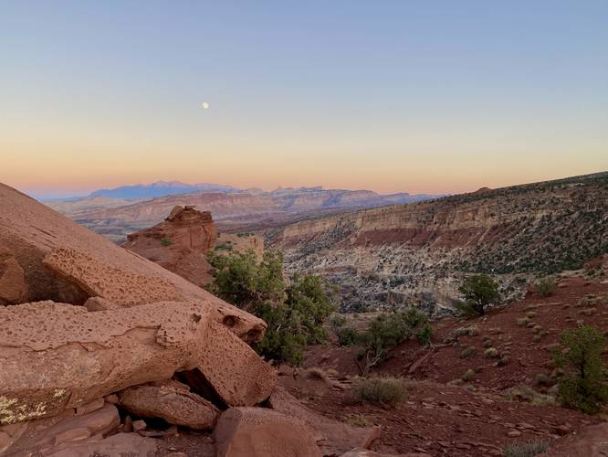
The trail then bends eastward once more as it makes its way along a flat dirt trail to make its way to canyonside viewpoints high above the Sulphur Creek canyon. Here, if you don't wish to join a larger group of people on Sunset Point rock (at the end of the trail), you can hang out here for the same view.
Sunset Point - Mile 0.4
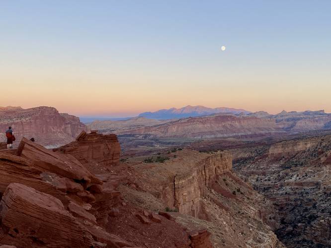
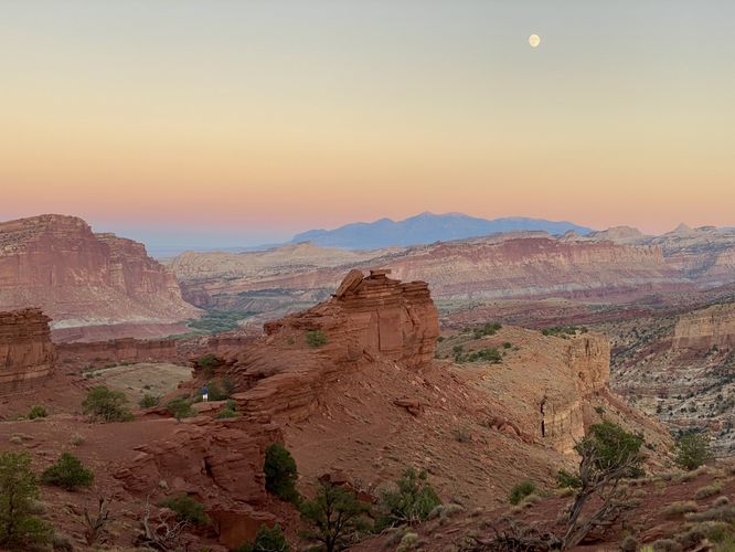
At mile 0.4, hikers will reach the large rock outcropping at the end of the trail known as Sunset Point. Note that this GPS data stops right before the rock as, during our hike, was covered in about 20 people for sunset. Hikers can enjoy the sunset, sunrise, or scenery from this part of the trail as it includes the best views of Capitol Reef National Park without putting in much physical work. Near Sunset Point rock, as of September 2023, was at least one bench for hikers to sit and watch the sunset over the distant mountains and rocky terrain in view.
Parking
Hikers will find a large parking lot at the coordinates provided - large enough to fit over a dozen vehicles.
Pets
Dogs are not allowed on this trail.
Warnings
Sun exposure: This trail has very little shade. Bring plenty of water and sun protection if planning to hike during mid-day sun, otherwise it's smart to plan to hike in the early morning or evening.
Rattlesnakes: Rattlesnakes call this area home and could be found out on the trail during warm/hot months. If found, please give these snakes plenty of space.
Ledges: This trail leads to steep, loose-rocked, ledges. Watch your step and stay back from sheer cliffs.
Trails
This hike follows the Sunset Point Trail.
Hike Description
This hike begins at the main trailhead for Sunset Point at Capitol Reef National Park located directly across the parking lot from the Goosenecks Point Overlook trailhead. The trail meanders uphill for a very short distance before it begins to flatten out. Hikers will begin the hike with a nice view of the western part of the park, including views of Chimney Rock and The Fluted Wall. As the trail flattens, it begins to curve southward as it opens up even more to sweeping views facing eastward.
The trail then bends eastward once more as it makes its way along a flat dirt trail to make its way to canyonside viewpoints high above the Sulphur Creek canyon. Here, if you don't wish to join a larger group of people on Sunset Point rock (at the end of the trail), you can hang out here for the same view.
Sunset Point - Mile 0.4
At mile 0.4, hikers will reach the large rock outcropping at the end of the trail known as Sunset Point. Note that this GPS data stops right before the rock as, during our hike, was covered in about 20 people for sunset. Hikers can enjoy the sunset, sunrise, or scenery from this part of the trail as it includes the best views of Capitol Reef National Park without putting in much physical work. Near Sunset Point rock, as of September 2023, was at least one bench for hikers to sit and watch the sunset over the distant mountains and rocky terrain in view.
Parking
Hikers will find a large parking lot at the coordinates provided - large enough to fit over a dozen vehicles.
Pets
Dogs are not allowed on this trail.
Warnings
Sun exposure: This trail has very little shade. Bring plenty of water and sun protection if planning to hike during mid-day sun, otherwise it's smart to plan to hike in the early morning or evening.
Rattlesnakes: Rattlesnakes call this area home and could be found out on the trail during warm/hot months. If found, please give these snakes plenty of space.
Ledges: This trail leads to steep, loose-rocked, ledges. Watch your step and stay back from sheer cliffs.