Loading...

🎉 Enjoy a Free 7-Day Supporter Trial and Unlock Exclusive Perks — No Credit Card Required. Learn more.

Chimney Rock View

Directions
Map
Pictures
Send to App
Distance:
0.4 Miles / 0.6 km
Type:
Out-and-Back
Difficulty:
Easy
Time to Hike:
~12 minutes
Features:
Surface Type:
Dirt
Park:
Capitol Reef National Park
Town:
Fruita, Utah
Directions:
38.315559, -111.304142
Added:
September 28, 2023
Updated:
October 04, 2023
Copy Trail Link Hiking this trail? Send a friend or family member a link to this trail guide for your own safety. Hike at your own risk (disclaimer)
Loading...
Loading...
24'

Total Change
26'

Ascent
26'

Descent

Download the Trail Route for Offline Use

Supporters get exclusive access to download trail routes to the MyHikes app for offline use. Stay prepared on your adventure, even without an internet connection! Become a Supporter today to unlock this feature and hike with confidence.

Send to App

Chimney Rock View

The Chimney Rock View at Capitol Reef National Park near Fruita, Utah is an easy 0.4-mile out-and-back hike that leads to an off-trail viewpoint of Chimney Rock.

Trails
This hike follows the Chimney Rock Trail.

Hike Description
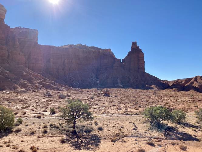
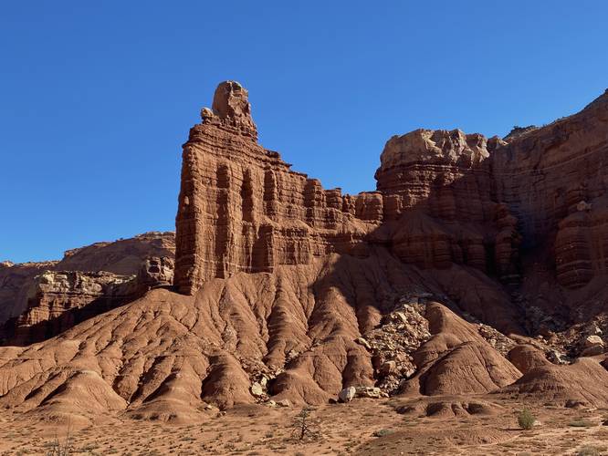
This very short hike begins at the main parking lot for Capitol Reef National Park's Chimney Rock Trail and follows the trail in for approximately 0.15-miles. Along the way are nice views of the surrounding area as the trail slowly ascends small hills as it makes its way northeast to reach larger uphill climbs. This hike doesn't hit any difficult ascents and instead veers off-trail around mile 0.15 to then hike up a small reef (rock barrier) to reach a beautiful view of Chimney Rock. From the top of this dirt mount / reef, hikers will get a nice view of Chimney Rock without simply just stepping outside of your car. This view, arguably, is much nicer at sunrise when the light is shining behind Chimney Rock.

Parking
Hikers will find a medium-sized parking lot at the coordinates provided, which is large enough to fit less than a dozen vehicles. There's some overflow parking for hikers along the dirt portions of the parking lot.

Pets
Dogs are not allowed on this trail.
Explore 20 trails near Fruita, UT
  1. Parking

    38.315559, -111.304142
  2. Main Trailhead

    38.315634, -111.304068
  3. View of Chimney Rock at Capitol Reef National Park

    38.317203, -111.302147
    View of Chimney Rock at Capitol Reef National Park
  4. View of Chimney Rock at Capitol Reef National Park (from road)

    38.312564, -111.301033
    View of Chimney Rock at Capitol Reef National Park (from road)
No community routes found. To add your own hike as a Community Route for this Trail guide, leave a Trip Report with an attached GPX file.

Hazards

Snakes

Seasons

All

Trip Reports

Trail Guide By:
Admin user profile picture
0.4 miles / 0.6 km
Preview of the MyHikes mobile app interface

Track, Log, and Explore Hikes with the MyHikes App

Shop Landscape Prints
Shop our landscape prints from Capitol Reef National Park

Weather Forecast

In Fruita, UT

Explore Hiking Trails

You May Also Like

Colorado's Million Dollar Highway - Plan a day's drive adventure along the iconic Million Dollar Highway in Colorado. Explore the best short trails, roadside stops, waterfalls, vistas, ghost towns, and hot springs within a ~6 hour road trip.
Explore

Colorado's Million Dollar Highway

Plan a day's drive adventure along the iconic Million Dollar Highway in Colorado. Explore the best short trails, roadside stops, waterfalls, vistas, ghost towns, and hot springs within a ~6 hour road trip.

Read
Glacier's Going-to-the-Sun Road - Discover the breathtaking beauty of Glacier National Park along the iconic Going-to-the-Sun Road. From stunning roadside stops to picturesque waterfalls and vistas, this engineering marvel offers endless opportunities for exploration.
Explore

Glacier's Going-to-the-Sun Road

Discover the breathtaking beauty of Glacier National Park along the iconic Going-to-the-Sun Road. From stunning roadside stops to picturesque waterfalls and vistas, this engineering marvel offers endless opportunities for exploration.

Read
New York's Best Waterfalls - Whether you're planning a day hike, roadside stop, or a leisurely short walk, this guide provides hikers, travelers, and locals alike with 63 different locations to over 100 scenic waterfalls to help plan your next adventure!
Explore

New York's Best Waterfalls

Whether you're planning a day hike, roadside stop, or a leisurely short walk, this guide provides hikers, travelers, and locals alike with 63 different locations to over 100 scenic waterfalls to help plan your next adventure!

Read

Before you boogie...

Find our trail guides useful? Consider becoming a Supporter to unlock perks!

MyHikes is an indie platform that makes exploring public trails easier for everyone. The platform has no investors, no ads, and is owned and operated by one person, Dave Miller. Dave has personally mapped and written over 1,800 trail guides on MyHikes for the public to explore. MyHikes has helped millions outdoor enthusiasts plan their next adventure.

But it takes a lot of time 🕦, money 💰, work, and espresso shots ☕ to run MyHikes, including hiking , mapping , writing , and publishing new trails with high-quality (accurate) information... along with software engineering (coding) the platform like building new features, website and mobile app development (iOS and Android), site maintainance . and much much more.

Supporters unlock website and mobile app perks with an annual one-time payment of $25 (you renew) 😎👍. Or you can simply make a Donation of your choice. Otherwise, you can support us by telling your friends about MyHikes - both quick and free 🎉

Admin user profile picture

Dave Miller
MyHikes Founder