Goosenecks Point Overlook at Capitol Reef National Park near Fruita, Utah is an easy 0.2-mile out-and-back hike that leads to stunning views of the 800-foot deep Sulphur Creek canyon.
Hike Description
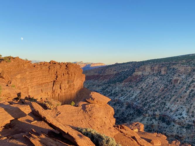
This hike begins at the main parking lot for Goosenecks and follows the Goosenecks Point Trail southwest as it first traverses a small hill and then runs along the steep, loose-rocked canyon high above Sulphur Creek. The trail meanders its way out to the end where Goosenecks Point lies where hikers will find two paths to take. This track follows the lower path out to the overlook where hikers are held-back from the edge by a fence. Here, you'll get stunning views of the sharp turns and curves that exist within Sulphur Creek canyon. Over millions of years, Sulphur Creek has carved its way through the bedrock, forming the sharp curves and twists that the water follows - also known as Goosenecks.
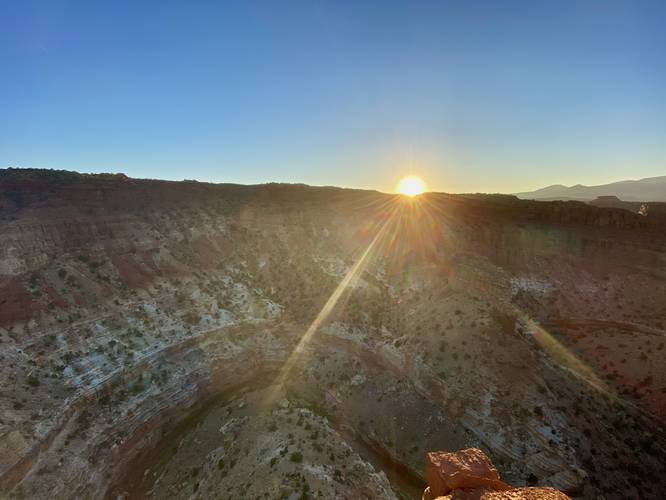
Sit around for sunset, sunrise, or to simply take a look into the 800-foot deep canyon before heading back. Before leaving the area, be sure to hike out to Sunset Point for a stunning view of Capitol Reef National Park (heads-up, it's busy during Sunset every day).
Parking
Hikers will find parking at the coordinates provided. The parking lot is large enough to fit a dozen vehicles or so.
Pets
Dogs are not allowed on this trail.
Warnings
Sun exposure: This trail has very little shade. Bring plenty of water and sun protection if planning to hike during mid-day sun, otherwise it's smart to plan to hike in the early morning or evening.
Rattlesnakes: Rattlesnakes call this area home and could be found out on the trail during warm/hot months. If found, please give these snakes plenty of space.
Ledges: This trail leads to steep, loose-rocked, ledges. Watch your step and stay back from sheer cliffs.
Hike Description
This hike begins at the main parking lot for Goosenecks and follows the Goosenecks Point Trail southwest as it first traverses a small hill and then runs along the steep, loose-rocked canyon high above Sulphur Creek. The trail meanders its way out to the end where Goosenecks Point lies where hikers will find two paths to take. This track follows the lower path out to the overlook where hikers are held-back from the edge by a fence. Here, you'll get stunning views of the sharp turns and curves that exist within Sulphur Creek canyon. Over millions of years, Sulphur Creek has carved its way through the bedrock, forming the sharp curves and twists that the water follows - also known as Goosenecks.
Sit around for sunset, sunrise, or to simply take a look into the 800-foot deep canyon before heading back. Before leaving the area, be sure to hike out to Sunset Point for a stunning view of Capitol Reef National Park (heads-up, it's busy during Sunset every day).
Parking
Hikers will find parking at the coordinates provided. The parking lot is large enough to fit a dozen vehicles or so.
Pets
Dogs are not allowed on this trail.
Warnings
Sun exposure: This trail has very little shade. Bring plenty of water and sun protection if planning to hike during mid-day sun, otherwise it's smart to plan to hike in the early morning or evening.
Rattlesnakes: Rattlesnakes call this area home and could be found out on the trail during warm/hot months. If found, please give these snakes plenty of space.
Ledges: This trail leads to steep, loose-rocked, ledges. Watch your step and stay back from sheer cliffs.