The Straight Run Waterfalls at Tioga State Forest near Asaph, Pennsylvania is an easy 1.4-mile out-and-back hike that features several small waterfalls with fishing holes and leads to two 4-foot tall waterfalls including Straight Run Falls.
Trails
This hike follows one named trail: Straight Run Trail (yellow blazes) which is a part of the Green Monster Trail System.
Fishing Holes
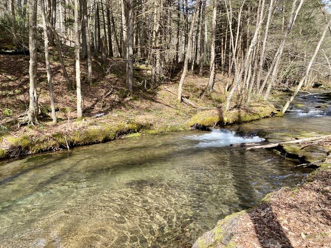
This trail is perfect for Spring-time fisherman/women as the creek is deepest during this season and provides many different shallow bedrock pools for fish to hide, especially under the churning waters of the small cascades (waterfalls) that spill over the rocky bedrock ledges in the creek. The light-colored bedrock also provides a beautiful tint to the color, as well as making fish easier to spot.
Hike Description
This hike begins at the main parking lot for the Straight Run Trail at the coordinates provided and follows the trail, heading north, as it follows alongside Straight Run creek. From the parking lot, the trail dips down to a seasonal creek that crosses the path, then back uphill where you'll pass official signage for the Straight Run Trail and Green Monster Trail.
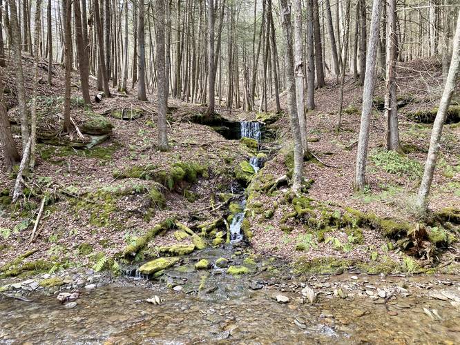
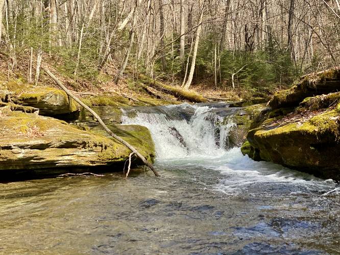
4-Foot Waterfall - Mile 0.05
Before you hike much further into the trail, hikers will find a small 4-foot waterfall with several smaller hillside cascades below it which sits across the creek. This waterfall can be appreciated from up-close if you're willing to get your feet wet or wade through Straight Run to reach the other side. This is one of the two most-scenic waterfalls along this hike.
After passing the first small waterfall, hikers will follow the trail as it winds its way upstream, passing several rocky outcroppings that sit 15-feet off-trail at the base of the hills (technically, the base of Mt. Nessmuk). These rocky outcroppings are also homes to Timber Rattlesnakes - I even spooked one on this hike on March 22, 2023 during a 50-degree day.
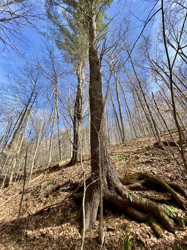
Old-Growth White Pine - Mile 0.15
Around mile 0.15, hikers will pass some very large old-growth white pine trees located off-trail to the east. Note that around here, in the rocky outcroppings below the trees, is where I spooked a Timber Rattlesnake in mid-to-late March 2023 (very very early in the season).
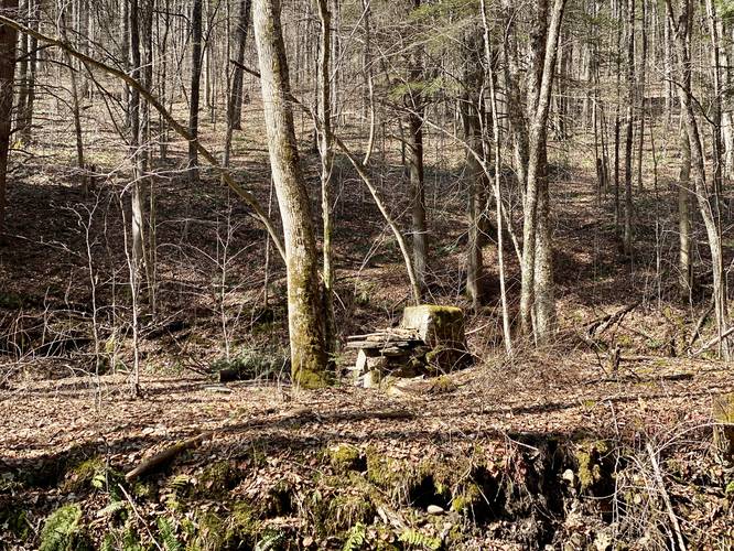
Abandoned CCC Site - Mile 0.45
Located around mile 0.45, hikers may spot an old chimney-like structure sitting across the creek on a plateaued hill. This chimney structure has been turned into a camp fire pit; however, it appears as though it was likely built by the CCC during the Great Depression era, or may be the remnants of an old homestead's chimney. Due to other CCC-built structures I've seen in the area, it's likely from that era.
Trail Junction - Mile 0.55
Around mile 0.55, hikers will reach a trail junction with (as of March 2023) a blown-over sign for the Deer Trail (aka Mt. Nessmuk Loop). In the GPS track provided, I went off-trail to reach a couple of small fishing hole waterfalls before heading up the Straight Run Trail once more to reach Straight Run Falls - hence the wonky looping data here.
Fishing Hole Falls - Mile 0.57 to 0.6
Between miles 0.57 and 0.6, both located slightly off-trail, there are two small fishing hole waterfalls. For each cascade, they're no more than 1-foot tall, but are about 5-10 feet wide (depending on the creek's flow). Below these cascades, the water churns, and is an inviting habitat for native brook trout (brookies).
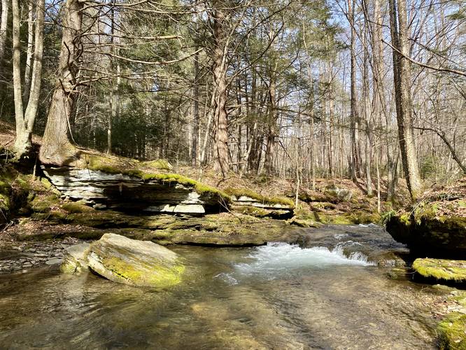
Straight Run Falls - Mile 0.65
Finally, hikers will reach the main attraction of this hike - Straight Run Falls - aroound mile 0.65. Straight Run Falls is a small 4-foot tall flume-like waterfall that spills down Straight Run creek into a fairly deep pool. This is another great spot to fish as the top of the waterfall is easily accessible and likely a great fishing hole.
Creek Junction, Turn-Around, Left Straight Run Trail - Mile 0.65 to 0.9
At mile 0.65, hikers will hit a junction with the creek. During seasons with high water flow, this trail is impassible unless you care to get your feet wet. Be careful of the fast-moving water near the top of Straight Run Falls as it begins to "flume" inward and gains speed before the waterfall. There are a couple of very small cascades located in the creek upstream from here as well. You can turn around here and as an optional hike, head up to Straight Run Road via the Left Straight Run Trail, then back down to the same path you hiked in on to reach mile 0.9. After this, hiking out is the same trail you walked in on, heading south.
Parking
Hikers will find a decent-sized parking lot at the coordinates provided, large enough to fit a half-dozen vehicles or so.
Pets
Dogs are allowed if leashed and must be cleaned up after.
Warnings
Timber Rattlesnakes: This area is home to the Timber Rattlesnake and they live in the rocky outcroppings adjacent to the creek, just off-trail, in the hillsides. These snakes use the creek as a water source and for hunting. General rule of thumb is the snakes are out roaming the forest from the end of April to early October each year. During warm sunny days, before or after these dates, the snakes can be found near their dens sunning themselves - as I spooked a rattlesnake on this hike in late March 2023 just from walking down the trail. Be on the lookout for rattlers and give any you find plenty of space.
Trails
This hike follows one named trail: Straight Run Trail (yellow blazes) which is a part of the Green Monster Trail System.
Fishing Holes
This trail is perfect for Spring-time fisherman/women as the creek is deepest during this season and provides many different shallow bedrock pools for fish to hide, especially under the churning waters of the small cascades (waterfalls) that spill over the rocky bedrock ledges in the creek. The light-colored bedrock also provides a beautiful tint to the color, as well as making fish easier to spot.
Hike Description
This hike begins at the main parking lot for the Straight Run Trail at the coordinates provided and follows the trail, heading north, as it follows alongside Straight Run creek. From the parking lot, the trail dips down to a seasonal creek that crosses the path, then back uphill where you'll pass official signage for the Straight Run Trail and Green Monster Trail.
4-Foot Waterfall - Mile 0.05
Before you hike much further into the trail, hikers will find a small 4-foot waterfall with several smaller hillside cascades below it which sits across the creek. This waterfall can be appreciated from up-close if you're willing to get your feet wet or wade through Straight Run to reach the other side. This is one of the two most-scenic waterfalls along this hike.
After passing the first small waterfall, hikers will follow the trail as it winds its way upstream, passing several rocky outcroppings that sit 15-feet off-trail at the base of the hills (technically, the base of Mt. Nessmuk). These rocky outcroppings are also homes to Timber Rattlesnakes - I even spooked one on this hike on March 22, 2023 during a 50-degree day.
Old-Growth White Pine - Mile 0.15
Around mile 0.15, hikers will pass some very large old-growth white pine trees located off-trail to the east. Note that around here, in the rocky outcroppings below the trees, is where I spooked a Timber Rattlesnake in mid-to-late March 2023 (very very early in the season).
Abandoned CCC Site - Mile 0.45
Located around mile 0.45, hikers may spot an old chimney-like structure sitting across the creek on a plateaued hill. This chimney structure has been turned into a camp fire pit; however, it appears as though it was likely built by the CCC during the Great Depression era, or may be the remnants of an old homestead's chimney. Due to other CCC-built structures I've seen in the area, it's likely from that era.
Trail Junction - Mile 0.55
Around mile 0.55, hikers will reach a trail junction with (as of March 2023) a blown-over sign for the Deer Trail (aka Mt. Nessmuk Loop). In the GPS track provided, I went off-trail to reach a couple of small fishing hole waterfalls before heading up the Straight Run Trail once more to reach Straight Run Falls - hence the wonky looping data here.
Fishing Hole Falls - Mile 0.57 to 0.6
Between miles 0.57 and 0.6, both located slightly off-trail, there are two small fishing hole waterfalls. For each cascade, they're no more than 1-foot tall, but are about 5-10 feet wide (depending on the creek's flow). Below these cascades, the water churns, and is an inviting habitat for native brook trout (brookies).
Straight Run Falls - Mile 0.65
Finally, hikers will reach the main attraction of this hike - Straight Run Falls - aroound mile 0.65. Straight Run Falls is a small 4-foot tall flume-like waterfall that spills down Straight Run creek into a fairly deep pool. This is another great spot to fish as the top of the waterfall is easily accessible and likely a great fishing hole.
Creek Junction, Turn-Around, Left Straight Run Trail - Mile 0.65 to 0.9
At mile 0.65, hikers will hit a junction with the creek. During seasons with high water flow, this trail is impassible unless you care to get your feet wet. Be careful of the fast-moving water near the top of Straight Run Falls as it begins to "flume" inward and gains speed before the waterfall. There are a couple of very small cascades located in the creek upstream from here as well. You can turn around here and as an optional hike, head up to Straight Run Road via the Left Straight Run Trail, then back down to the same path you hiked in on to reach mile 0.9. After this, hiking out is the same trail you walked in on, heading south.
Parking
Hikers will find a decent-sized parking lot at the coordinates provided, large enough to fit a half-dozen vehicles or so.
Pets
Dogs are allowed if leashed and must be cleaned up after.
Warnings
Timber Rattlesnakes: This area is home to the Timber Rattlesnake and they live in the rocky outcroppings adjacent to the creek, just off-trail, in the hillsides. These snakes use the creek as a water source and for hunting. General rule of thumb is the snakes are out roaming the forest from the end of April to early October each year. During warm sunny days, before or after these dates, the snakes can be found near their dens sunning themselves - as I spooked a rattlesnake on this hike in late March 2023 just from walking down the trail. Be on the lookout for rattlers and give any you find plenty of space.