Sleepily tucked away between the dramatic Linville Gorge to the west, and the well-known waterfalls of the Wilson Creek Wild and Scenic River Area to the east, the Steels Creek Gorge is a treasure-trove of dramatic waterfalls unbeknownst to the average hiker. There are 5 named waterfalls on Steels Creek along this section, including Steels Creek Falls, and 6 more known waterfalls on tributaries of the creek. In total, this hike brings you to viewing points for 5 waterfalls. Of course, if you’re the adventurous type you can see more with a good map and directions from North Carolina Waterfalls Third Edition. The highlights are Steels Creek Falls and Beverly Hillbilly Falls, both impressive and unique waterfalls that bely description. In addition to multiple creek fords on this hike, the only way to see Beverly Hillbilly Falls is a 0.3-mile creek-walk/bouldering expedition upstream. If you’re not comfortable with this we advise you to skip it, the other waterfalls should suffice. This is also a great area for camping and swimming. There are nice campsites right beside the Mountains-to-Sea Trail and Steels Creek that are ripe for a weekend basecamp utilized best for fishing, swimming, and waterfall exploration.
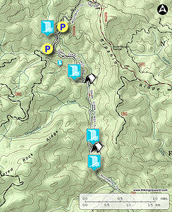
- Mile 0.0 – Beginning at the Steels Creek Trail [237] and Mountains-to-Sea Trail [440] (white blaze) on FR 496, head east past the gate going downhill on a wide forest road track.
- Mile 0.1 – T-junction with the old MST on the left. In 100 feet you’ll pass an overgrown forest road grade on the right. (This overgrown path on the right is beginning of a bushwhack to see Zigzag Falls. Following the path down towards an old campsite is easy, but the rest is extremely difficult and dangerous. The waterfall is listed in North Carolina Waterfalls Third Edition, see the book for more information.)
- Mile 0.8 – As the trees open up on the right, you’ll see a short side path down to exposed bedrock. This is the top of Rip Breeches Falls. If the rock is dry you can walk to the base, but the pool at the bottom left means it is not possible to view this waterfall without getting wet or sliding down. This hike travels to the base of the waterfall starting at the creek downstream, at Mile 5.1.
- Mile 1.0 – Pass through a very large grass field with campsites and an old trail leading off to the left. After this clearing is your first crossing of a tributary to Steels Creek.
- Mile 1.15 – Wet crossing (#1) of Steels Creek.
- Mile 1.45 – Wet crossing (#2) of Steels Creek.
- Mile 1.5 – Wet crossing (#3) of Gingercake Creek. On the other side of the creek is a nice, wooded campsite.
- Mile 1.55 – Above to your right is a large grass field, a former orchard, that also presents camping opportunities. The unofficial Lettered Rock Trail begins at the edge of the field heading southwest towards FR 496.
- Mile 1.8 – On the left of the trail is a very nice campsite above Teacups Falls.
- Mile 1.9 – There is a scramble trail on the left to the middle of Teacups Falls where you can see the upper drops and the slide below.
- Mile 2.0 – A scramble trail on the left leads to the sandy beach at the base of Teacups Falls. This multi-tiered waterfall has many small drops above over sculpted rocks, and culminates in a pretty 20-foot slide into a shallow pool. This is just an appetizer for the waterfalls later in the hike. Downstream is a massive boulder garden that precludes Beverly Hillbilly Falls. Do not wander downstream to explore, this is dangerous territory.
- Mile 2.3 – The MST earnestly switchbacks down the ridge. Steels Creek below Teacups Falls drops into a gorge that can be seen through the trees.
- Mile 2.6 – At the base of the switchbacks is another excellent campsite. If you wish to see Beverly Hillbilly Falls, you need to leave the trail here by turning left and getting into Steels Creek. This creek walk is easy until you get close to the waterfall, where you’ll have to navigate around a large set of boulders. It is approximately 0.2-mi to the boulder field and 0.35-mi to the base of the waterfall. Once you get to the large pool above the first boulder field, the driest way to proceed is to get out of the creek and clamber up the bank on the right side.
- Mile 2.9 – Reach the base of Beverly Hillbilly Falls, a unique double-slide waterfall. The creek steeply slides over massive cliff approximately 25 feet, then makes an abrupt right-hand turn following a narrow rock chute. The creek then turns left over a short, shallow slide into the larger base pool. The water here is deep and beautiful in the chute. It is easy to walk beside the chute right up to the main waterfall. This waterfall is also known as Screaming Right Hand Turn Falls, the name seems appropriate. Turn around and make your way back downstream to the campsite.
- Mile 3.2 – Back on the MST continue south.
- Mile 3.3 – The MST drops down over drainage and begins following bedrock beside Steels Creek. During above average water levels the trail will be submerged.
- Mile 3.5 – A scramble trail on the left leads down to a massive, sloped boulder in the middle of Steels Creek Falls. Use extreme caution here, the path and rock are not level, and typically wet. There is an old rope anchored to help you shimmy down the rock for a better view, but you cannot fully trust the integrity of a rope left by someone else. It is highly recommended to stay far away from the edge of this rock, or do not scramble on it at all. The rock juts out into the middle of the waterfall, so one slip will send you into the falls. From wherever you stand you will get a great view of the upper drops of Steels Creek Falls. There are multiple short drops over smooth, sculpted rock into enormous potholes. There is also a shorter, steeper, and more dangerous scramble path to see the very top of the waterfall. There is no rope here to help you. You should ignore this, the view isn’t worth the risk. Also, you cannot see the base of the waterfall from the trail. It requires an incredibly steep and difficult bushwhack, or a long creek-walk through deep pools far downstream. Once you are done viewing Steels Creek Falls turn around and head north on the MST upstream.
- Mile 5.1 – If you wish to see Rip Breeches Falls from the base, leave the MST and follow the tributary upstream. The tributary is almost flat with no obstacles but a few downed trees. (Rip Breeches Falls is easy to reach but by no means exemplary. If you skip this continue on the MST which parallels this tributary. The waterfall bushwhack rejoins the MST at Mile 5.5.)
- Mile 5.4 – Reach the base of Rip Breeches Falls. The unnamed tributary to Steels Creek flows over 40 feet down the left side of the open rock. To rejoin the MST, either climb up the rock or turn right and do a short bushwhack through the woods.
- Mile 5.5 – Back on the MST, turn left heading west uphill.
- Mile 6.3 – Turn right on the old MST. (Or continue straight to cut this hike short, leaving out the last two waterfalls.)
- Mile 6.6 – Cross Steels Creek at the top of Newt Falls. The only way to see this waterfall is a dangerous scramble down the steep rock face to the left of the waterfall. This is not recommended, the waterfall isn’t worth the danger.
- Mile 6.8 – The old MST ends at a campsite beside FR 496. Turn left walking south on FR 496.
- Mile 6.95 – Just before FR 496 crosses over Steels Creek, look for a side path on the right and follow it upstream.
- Mile 7.0 – The side path ends at the base of Upper Steels Creek Falls. This steep slide is over 50 feet high, and plummets from high above out-of-sight. Unfortunately, this waterfall is usually cluttered with downfall at the base and rhododendron above, obscuring great views.
- Mile 7.1 – Turn right on FR 496.
- Mile 7.4 – Hike ends at the MST gate on FR 496.