The Springdell Cascade Trail in Uinta-Wasatch-Cache National Forest in Provo, Utah is a moderate 2.4-mile out-and-back hike that leads to the 120-foot tall waterfall known as Springdell Cascade or Smith Ditch Falls No. 1.
Hike Description
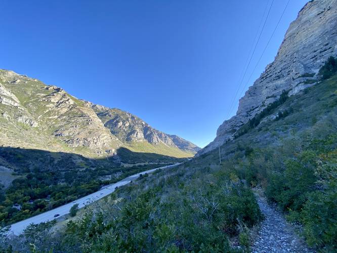
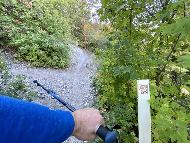
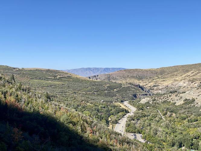
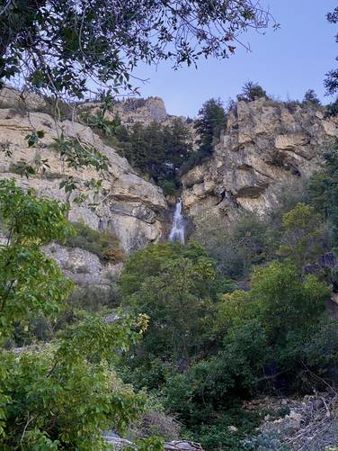
This hike begins at the southern end of Bridal Veil Falls Park and follows the bike trail for just a few-hundred feet to reach the trailhead of the Bonneville Shoreline Trail. Note that the Bonneville Shoreline Trail does not have any signage. Once on the Bonneville Shoreline Trail, hikers will be hiking along a very-skinny path that meanders its way through a forest of thick brush and trees. Eventually, hikers will reach an opening in the trail, under the powerlines, where you'll get a view of the Provo Canyon - both up the canyon and back toward the city of Provo. At the powerlines, hikers will also find Springdell Falls / Smith Ditch Falls No. 1 cascading down the cliff side - you can also spot other nearby waterfalls here too, at least one was completely dried-up in late September 2023.
Left-Turn - Mile 0.85
Around mile 0.85, hikers will come to a 4-way trail junction. Take a left-hand turn here.
Views - Mile 0.9 to 1.15
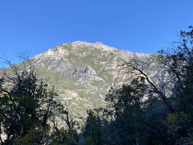
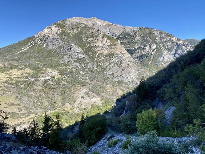
Starting at mile 0.9, hikers will get more views into the Provo Canyon, toward the city of Provo, of Mt. Timpanogos, and even a downstream glimpse of Springdell Falls / Smith Ditch Falls No. 1. This is also where the elevation grade becomes steeper - not too difficult, but where the "moderate" difficulty kicks-in.
Springdell Falls / Smith Ditch Falls No. 1 - Mile 1.2
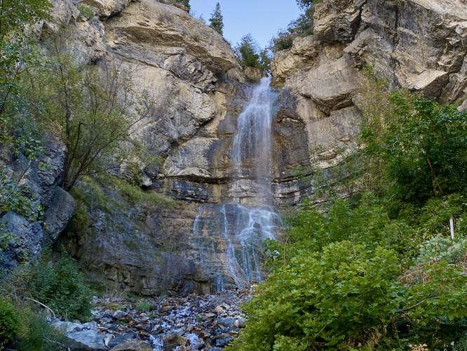
Finally, after the trail makes one final sharp turn, hikers will reach Springdell Falls aka Smith Ditch Falls No. 1 at mile 1.2. From below Springdell Falls, hikers can take a well-deserved break to take in the views of the waterfall or Mt. Timpanogos behind you. The waterfall is just massive, stunning, and a bit loud - I guestimated the height of this waterfall to be about 120-feet tall and while the estimation is likely wrong (it could be taller), this super-secluded and seldom-visited waterfall was worth hiking to. On this hike, I stuck around for about 15 minutes to enjoy the scenery of Springdell Cascade before hiking down and back to parking for a 2.4-mile hike.
Parking
Hikers will find a large parking lot at the parking coordinates provided, which leads to the southern parking lot at Bridal Veil Falls Park.
Pets
Dogs are allowed if leashed and must be cleaned up after.
Warnings
Rockfalls: The cliffs surrounding Springdell Cascade / Smith Ditch Falls No. 1 calve off and cause rockfalls to happen randomly and suddenly - these could happen at any time so be mindful and watch out.
Snow-melt undermining: In the Spring, snow melt can cause undermining of snowfields which can be dangerous to hike on as the hiker doesn't know how thin the snow is or how far down it might plunge below. Sometimes this area is closed in early Spring due to avalanches and snow-melt undermining.
Weird Noises on the Trail (September 2023)
Something odd to note (I would be curious if any locals could clue me in on this).. when I was hiking this trail, between mile 0.9 and 1, I heard some very strange noises up in the mountains between the trail and the cliff side. The noise sounded like machinery, as if an open pit mine or something similar was operating on the mountain. This noise sounded mechanical and continuous - like a grinding and tumbling of rock. The strange part was all I could hear was this noise and it was emanating from the cliff side above the trail. I saw no signs of machinery and the noise was only present when standing down the hill from that spot. If anyone knows what that was / is, I'd be curious to find out myself - feel free to leave a trip report or reach out with info.
Hike Description
This hike begins at the southern end of Bridal Veil Falls Park and follows the bike trail for just a few-hundred feet to reach the trailhead of the Bonneville Shoreline Trail. Note that the Bonneville Shoreline Trail does not have any signage. Once on the Bonneville Shoreline Trail, hikers will be hiking along a very-skinny path that meanders its way through a forest of thick brush and trees. Eventually, hikers will reach an opening in the trail, under the powerlines, where you'll get a view of the Provo Canyon - both up the canyon and back toward the city of Provo. At the powerlines, hikers will also find Springdell Falls / Smith Ditch Falls No. 1 cascading down the cliff side - you can also spot other nearby waterfalls here too, at least one was completely dried-up in late September 2023.
Left-Turn - Mile 0.85
Around mile 0.85, hikers will come to a 4-way trail junction. Take a left-hand turn here.
Views - Mile 0.9 to 1.15
Starting at mile 0.9, hikers will get more views into the Provo Canyon, toward the city of Provo, of Mt. Timpanogos, and even a downstream glimpse of Springdell Falls / Smith Ditch Falls No. 1. This is also where the elevation grade becomes steeper - not too difficult, but where the "moderate" difficulty kicks-in.
Springdell Falls / Smith Ditch Falls No. 1 - Mile 1.2
Finally, after the trail makes one final sharp turn, hikers will reach Springdell Falls aka Smith Ditch Falls No. 1 at mile 1.2. From below Springdell Falls, hikers can take a well-deserved break to take in the views of the waterfall or Mt. Timpanogos behind you. The waterfall is just massive, stunning, and a bit loud - I guestimated the height of this waterfall to be about 120-feet tall and while the estimation is likely wrong (it could be taller), this super-secluded and seldom-visited waterfall was worth hiking to. On this hike, I stuck around for about 15 minutes to enjoy the scenery of Springdell Cascade before hiking down and back to parking for a 2.4-mile hike.
Parking
Hikers will find a large parking lot at the parking coordinates provided, which leads to the southern parking lot at Bridal Veil Falls Park.
Pets
Dogs are allowed if leashed and must be cleaned up after.
Warnings
Rockfalls: The cliffs surrounding Springdell Cascade / Smith Ditch Falls No. 1 calve off and cause rockfalls to happen randomly and suddenly - these could happen at any time so be mindful and watch out.
Snow-melt undermining: In the Spring, snow melt can cause undermining of snowfields which can be dangerous to hike on as the hiker doesn't know how thin the snow is or how far down it might plunge below. Sometimes this area is closed in early Spring due to avalanches and snow-melt undermining.
Weird Noises on the Trail (September 2023)
Something odd to note (I would be curious if any locals could clue me in on this).. when I was hiking this trail, between mile 0.9 and 1, I heard some very strange noises up in the mountains between the trail and the cliff side. The noise sounded like machinery, as if an open pit mine or something similar was operating on the mountain. This noise sounded mechanical and continuous - like a grinding and tumbling of rock. The strange part was all I could hear was this noise and it was emanating from the cliff side above the trail. I saw no signs of machinery and the noise was only present when standing down the hill from that spot. If anyone knows what that was / is, I'd be curious to find out myself - feel free to leave a trip report or reach out with info.