Loading...

❄️ WINTER SALE! 50% OFF on Supporter Accounts — now through January 31st. Unlock a full year of exclusive website & app perks. Learn More.

Shuckstack Lookout Tower Hike

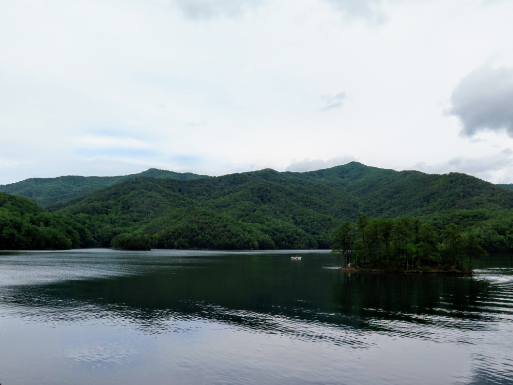
The Appalachian Trail first enters Great Smoky Mountains National Park by crossing Fontana Dam then vigorously climbs towards Shuckstack lookout tower. In 1944 the Little Tennessee River was dammed to form Fontana Lake, which drastically changed the regional landscape. Formerly, the Appalachian Trail passed through Deals Gap and climbed to Gregory Bald along the state line. In 1947 the trail was rerouted across Fontana Dam to ascend Shuckstack, the site of one of the tallest lookout towers in North Carolina. Officially, the Appalachian Trail does not cross the summit of Shuckstack, but a short 0.1-mile side trail brings you to the 60-foot lookout tower with outstanding 360° views of the region. This is a popular hike despite its difficulty and you will see many day hikers, backpackers, and thru hikers on this trek. From the stairs you can see most of Fontana Lake, the Cheoah Mountains, Snowbird Mountains, Unicoi Mountains, and the remote interior of the southwestern Great Smoky Mountains. Despite its relatively low elevation, the views from Shuckstack are considered among the best in the national park.  

While you’re there – Save some time 
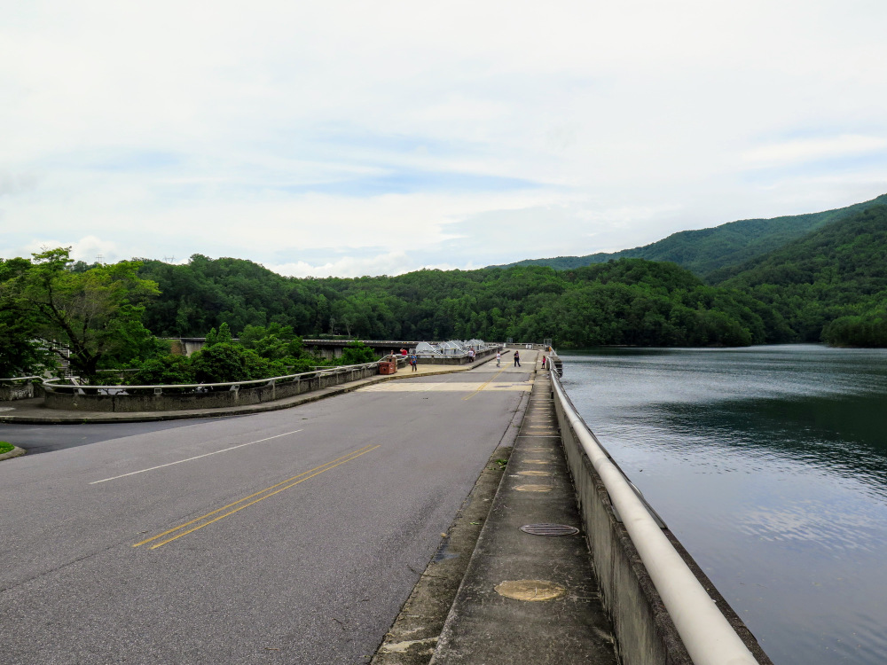
to stop at Fontana Dam, the tallest in the East at 480 feet. There are multiple locations to park around the dam, and you can walk across the entirety of the dam and check out the visitors center. From the dam you can see Shuckstack lookout tower high above the lake. The Appalachian Trail crosses the dam and follows Lakeshore Drive, but this is nearly 1 mile from the trailhead. If you choose to park here for the hike it would be an 8.6-mile round trip.

  • Mile 0.0 – Lakeshore Drive dead ends at the trailheads for the Appalachian Trail and the Lakeshore Trail. At the end of the pavement, the gated Lakeshore Trail begins straight ahead while the Appalachian Trail (white blaze) makes a left turn. For the next 3.3 miles you’ll get few views as the Appalachian Trail climbs over 2,100 feet from Fontana Lake to Shuckstack. Along the way you’ll pass through thick forest cover with few large hardwood trees and a lush understory of ferns and nettles.

  • Mile 2.8 – Cross over rock slabs with a southwest view of the Snowbird and Unicoi Mountain ranges.

  • Mile 3.2 – At the top of the ridge the Appalachian Trail turns left heading downhill while the unmarked summit trail to Shuckstack continues straight.

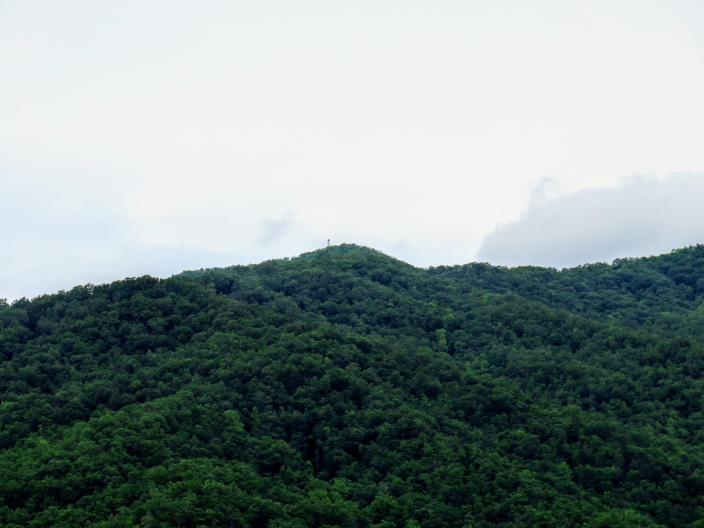
  • Mile 3.3 – The trail ends at the top of Shuckstack (4,024 feet). The 60-foot tower was originally built in 1934 and is publicly accessible. You’ll have to climb 78 steep stairs to reach the top cab. The cab is open but the views are partially obscured by intact windows. The best views are from the stairs just below the top cab. The vast Fontana Lake spreads out below you from south to east. Located due south directly above the lake are the Yellow Creek Mountains, which are dominated by the taller Cheoah Mountains in the background. The Snowbird Mountains and Unicoi Mountains are the long, contiguous ranges to the southwest beyond Cheoah Lake. Gregory Bald is the broad peak immediately northwest across the Twentymile Creek watershed. Thunderhead Mountain is the tallest peak due north above the expansive Eagle Creek watershed. In the distant northeast beyond the Hazel Creek watershed lies Clingmans Dome, the tallest peak in the national park.    

  • Mile 3.5 – Return to the parking area by taking the Appalachian Trail south. For a longer, optional loop – head north on the Appalachian Trail to Sassafras Gap and turn right on the Lost Cove Trail which connects to the Lakeshore Trail. This would be approximately 12 miles and would give you access to backcountry campsites #91 and #90.

  • Mile 6.8 – Hike ends at Lakeshore Drive.
By HikingUpward Contributor: Zach Robbins
Explore 16 trails near Fontana Dam, NC

Know Before You Go

  • The Shuckstack Lookout Tower hike, a 6.8-mile roundtrip from the Lakeshore Drive trailhead, offers outstanding 360° views from a 60-foot fire tower despite its challenging 2,100-foot elevation gain.
  • The Appalachian Trail was rerouted in 1947 to cross Fontana Dam and ascend Shuckstack due to the creation of Fontana Lake, highlighting the impact of dam construction on trail routes.
  • Besides the hike, visitors can explore Fontana Dam, the tallest dam in the Eastern United States, with accessible parking, a visitors center, and views of Shuckstack Lookout Tower.
Interactive topographic map for Shuckstack Lookout Tower Hike located in Fontana Dam, NC. Click the "View Map" button to load GPS coordinates and trail markers.
Get directions
Distance
6.8 mi
Difficulty
Hard
Type
Out-and-Back
Est. Time
3.4 hrs
Elev. Gain
2,219'
Rating
0.0
Added
January 23, 2025
Updated
April 04, 2025

Weather Forecast

Loading...
Total Change
2,087'
Ascent
2,219'
Descent
2,219'
Loading...

Download the GPX Data for Offline Use

Supporters get exclusive access to download trail routes to the MyHikes app for offline use. Stay prepared on your adventure, even without an internet connection! Become a Supporter today to unlock this feature and hike with confidence.

Download Shuckstack Lookout Tower Hike GPX Data to the MyHikes Mobile App

Features

Vista / Lookout Point
Dogs
Mountain Summit
Appalachian Trail logo Appalachian Trail hike

Points of interest

  1. Parking

    35.460326, -83.811118
  2. Main Trailhead

    35.460633, -83.810996

Safety information

For your own safety: plan ahead, let someone know where you'll be, and hike at your own risk.

Hazards

Snakes (Rattlesnakes, Copperheads, others)
Poison Ivy or Poison Oak

Availability

All seasons

Surface type

Dirt

Trip Reports (Reviews)

Your opinion matters! Be the first to rate this trail.

Ready to help fellow hikers? Add a trip report to share your experience and provide valuable insights for other hikers!

No community routes found. To add your own hike as a Community Route for this Trail guide, leave a Trip Report with an attached GPX file.

Popular categories

Scenic mountain view representing vista trails
Vista trails
Scenic gorge of cascades representing waterfall trails
Waterfall hikes
Rugged mountain terrain representing summit trails
Summit trails
Scenic mountain view representing dog-friendly trails
Dog-friendly
Scenic campsite with a view representing camping trails
Camping trails
Appalachian Trail logo representing A.T. hikes
A.T. hikes

You May Also Like

25 Best Day Hikes in North Carolina - Discover the top 25 best day hikes in North Carolina, from breathtaking waterfalls to mountain peaks. Explore hidden gems, scenic views, and trails suitable for all skill levels, perfect for your next outdoor adventure.
Explore

25 Best Day Hikes in North Carolina

Discover the top 25 best day hikes in North Carolina, from breathtaking waterfalls to mountain peaks. Explore hidden gems, scenic views, and trails suitable for all skill levels, perfect for your next outdoor adventure.

Read
Colorado's Million Dollar Highway - Plan a day's drive adventure along the iconic Million Dollar Highway in Colorado. Explore the best short trails, roadside stops, waterfalls, vistas, ghost towns, and hot springs within a ~6 hour road trip.
Explore

Colorado's Million Dollar Highway

Plan a day's drive adventure along the iconic Million Dollar Highway in Colorado. Explore the best short trails, roadside stops, waterfalls, vistas, ghost towns, and hot springs within a ~6 hour road trip.

Read
Glacier's Going-to-the-Sun Road - Discover the breathtaking beauty of Glacier National Park along the iconic Going-to-the-Sun Road. From stunning roadside stops to picturesque waterfalls and vistas, this engineering marvel offers endless opportunities for exploration.
Explore

Glacier's Going-to-the-Sun Road

Discover the breathtaking beauty of Glacier National Park along the iconic Going-to-the-Sun Road. From stunning roadside stops to picturesque waterfalls and vistas, this engineering marvel offers endless opportunities for exploration.

Read
🍪 We use cookies to learn about site usage and to serve map tiles. You may block cookies manually in the browser. By continuing you agree. Learn more