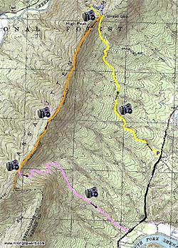
The only real downside to the loop is the final 1.2 mile walk along VA613 back to the parking area. There isn't much traffic as it is basically a single lane dirt road but you do have to keep alert.
Start by passing the gate and gradually climbing uphill on the yellow blazed Shawl Gap Trail as it begins its assent. After 1.2 miles arrive at a large animal habitat clearing that gives great views of the mountain and Shenandoah Valley. Continue and in another 1.2 miles arrive at the intersection where Shawl Gap Trail turns left uphill (turning right leads down to VA613).
Turn left uphill still on the yellow blazed Shawl Gap Trail for another 0.5 miles until reaching the crest of the ridge and the four way intersection of the Tuscarora/Massanutten Trail. Turn left on the now blue/orange blazed Tuscarora/Massanutten trail as it ascends and follows the ridge line. There are several great views along both sides of the ridge with one in particular just after you pass High Peak.
In 1.9 miles since turning left on the ridge you will reach pink blazed Sherman Gap Trail as it descends to your right. Continue straight on the ridge for an other 0.4 miles where you will reach the Sherman Gap Trail's descent to the left.
Turn left downhill on the pink blazed Sherman Gap Trail as it winds down a small valley for 2.5 miles before reaching VA613. You will pass close to private property on your left just before you reaching US613 so make sure to remain on the trail.
Sherman Trail ends at US613 (there is no parking there) Turn left walking along US613 for 1.2 mile as it winds back to the parking lot which will be located on your left.