Located deep in the South Toe River valley, the Black Mountain Campground is a hub of outdoor activity. While there you can camp, stroll to Setrock Creek Falls, swim in the South Toe River, or tackle difficult hikes to Green Knob and Mount Mitchell. However, the trails that encircle the campground outside of Setrock Creek Falls receive little traffic compared to the Mount Mitchell Trail. If you want to see the waterfall but are also in the mood for a longer hike, consider this loop around the South Toe River that includes the Lower River Loop, Devil’s Den Nature, Setrock Creek Falls, and River Loop Trails. During this hike you will have multiple opportunities to explore rocky beaches along the river and get occasional views of the high mountains surrounding the valley. Other than the waterfall portion, you will likely see few people on this hike despite its proximity to the campground. This is an excellent alternative to the difficult hikes in the area, especially on a cloudy day.
Alternate parking – You can also park at the Black Mountain Campground hiker’s lot which has been recently expanded to accommodate many cars.
Nearby hike options:
Green Knob Trail | Mount Mitchell Trail | Roaring Fork Falls
-
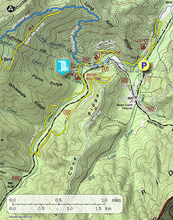
Mile 0.0 – Park at the South Toe River Fishing Access and follow the gravel path to connect with the Lower River Loop Trail [200a] (yellow blaze). At the trail junction turn right following the trail downstream. This new trail parallels the South Toe River passing through swaths of ferns.
-
Mile 0.3 – The trail passes through the Lost Cove Picnic Area. After the picnic area the trail hugs South Toe River Rd.
-
Mile 0.6 – T-junction with an access trail on the right. Turn left to cross the river.
-
Mile 0.7 – Cross the lower pedestrian bridge over the South Toe River. From the bridge you will have good views upstream and downstream.
-
Mile 1.3 – Excellent riverside views from a rocky beach downstream of the upper pedestrian bridge.
-
Mile 1.35 – T-junction with the loop trail split at the upper pedestrian bridge, continue straight.
-
Mile 1.75 – T-junction with the Devil’s Den Nature Trail, Turn right to begin the nature trail. If you do not wish to include the trail you can continue straight towards the campground. The Devil’s Den Nature Trail [192] (white blaze) is a short 0.7-mi loop with interpretative signs identifying the local plant life.
- Mile 2.3 – Devil’s Den Nature Trail turns left before picnic tables above Black Mountain Campground Road to reconnect with the loop. We continued straight here through the picnic area to follow the west side of the campground road.
-
Mile 2.4 – Black Mountain Campground facilities and multiple campground road junctions on the north side of the bridge over the South Toe River. Follow the signs and blazes indicating the direction of the Mount Mitchell Trail and in 100 feet veer left onto the Briar Bottom Bicycle Trail [1006], the Mountains-to-Sea Trail [440] (white blaze), and River Loop Trail [200] (yellow blaze).
-
Mile 2.65 – T-junction with the Mount Mitchell Trail [190] (blue blaze) and Mountains-to-Sea Trail on the right. Continue straight on the Briar Bottom Bicycle Trail and the River Loop Trail.
-
Mile 2.7 – Cross a metal bridge. On the other side of the bridge turn right onto the Setrock Creek Falls Trail [197] (white blaze).
-
Mile 2.75 – Cross Briar Bottom Group Camp Road.
-
Mile 2.9 – The trail ends at Setrock Creek Falls, a multilevel cascading waterfall between 60-70 feet in height.
**Note – The large tree across the base of the waterfall was removed after this hike took place.
-
Mile 3.1 – Turn right onto the River Loop Trail and soon you will cross a wooden bridge over Setrock Creek.
-
Mile 3.3 – Multiple paths on the right lead to Briar Bottom Group Campground.
-
Mile 3.4 – The River Loop Trail crosses Briar Bottom Group Camp Road twice in quick succession. There are bathrooms beside the second crossing. The trail beyond Briar Bottom Group Campground is lightly trafficked. Occasionally you will have nice views of the South Toe River.
-
Mile 3.8 – Rock hop an unnamed tributary.
-
Mile 4.0 – Rock hop Camp Creek. In above average water you will likely have to ford the creek.
-
Mile 4.5 – The River Loop Trail meets South Toe River Road and crosses the South Toe River on the road bridge. From the bridge you will have fantastic views upstream of the mountains surrounding the South Toe River headwaters. On the other side of the bridge turn right onto the trail leaving the road.
Now on the east side of the river, the River Loop Trail climbs a slope 100 feet above the river with occasional views of the Black Mountains high above the valley. -
Mile 5.0 – Loop around the southern outskirts of a large, grassy field. After this field, the trail stays well-removed from the river for a mile.
-
Mile 6.0 – Y-junction with the Green Knob Trail [182] (white blaze) on the right.
-
Mile 6.1 – Y-junction with the Mountains-to-Sea Trail (white blaze). Turn left following the Mountains-to-Sea Trail and River Loop Trail towards the campground.
-
Mile 6.4 – Trailhead at the Black Mountain Campground hiker’s parking lot. Follow the road over the South Toe River bridge. Continue past the facilities and turn right on the Black Mountain Campground Road.
-
Mile 6.5 – Turn right leaving the road to follow the Devil’s Den Nature Trail and Lower River Loop Trail. Cross a small bridge and turn right on the Lower River Loop Trail.
-
Mile 7.8 – Hike ends at the South Toe River Fishing Access.