The School House Hollow Trail at Tioga State Forest in Wellsboro, Pennsylvania is a strenuous 3.1-mile out-and-back trail that features an old historical schoolhouse along with a mountain summit climb to Oak Point Mountain.
Trail Description
Hikers first need to note that this trailhead, and the first 0.5-miles up the mountain, follows a right-of-way along private property. Please respect land owners and stay on the trail at all times while hiking along the private property section.
The trailhead has no sign, but can be found across the street from a field of cows. The trail follows the edge of this private property as it heads uphill before following a right-hand curve as it heads deeper into the woods. Hikers will get a nice view of the Marsh Creek valley and surrounding mountains and hills facing Wellsboro, PA just before heading into the woods. This small view, while really nice, is the only unobstructed view the hiker gets while exploring this trail and Oak Point Mountain.
After the trail heads into the woods, following the right-hand curve, it follows about 150-feet from School House Hollow Run - the creek that flows down Oak Point Mountain all-year long. While the creek sounds like it may boast a waterfall or two, any cascade found within the creek is not much taller than about 2-feet tall.
School House / Point of Interest
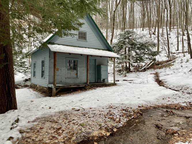
At mile 1.2, hikers will reach an old blue school house that sits directly on School House Hollow Run. This old school house is a tiny remnant of what was likely tied to a small logging community in the 1800s or early 1900s. I did not try to enter the building, but from the outside I could see a buck's rack and old framed photos on the wall, what looked like an old gas lantern hanging from the ceiling, stools upside-down on what were likely desks in the main room. Near the front of the building it had a skinny staircase leading to the 2nd story with small doors closing off the school room. The front of the school house had what appeared to be an ice chest of sorts. And about 50-feet away is, what looks to be, a still-working outhouse. In the front of the school house, the creek flows downhill where it seems an old wooden well was dug out leading water to - what I assumed - is working plumbing inside the school house. Many assumptions were made on this hike about this building, so I plan to go back to go back and explore it further.
After visiting the school house, hikers will pass a yellow gate which is meant to keep motorized vehicles out. After the gate, the trail will finally level out as it makes its way toward the end of the trail after another 0.2-miles of hiking.
At the end of this trail hikers are basically at the top of Oak Point Mountain. Take right-hand turn and hike for 100-feet to find a large open area. At this open area, hikers are met with a several options for more trails to hike on. For example, hikers can take the Oak Point Mountain Trail - a very-flat trail that has fork with two downhill paths that you can hike for an additional workout. The top of Oak Point Mountain is quiet, with very little to see aside from the obstructed views of neighboring mountains and scarce similar "views" towards Wellsboro, PA.
The hike back to parking is identical to the hike up, but is all downhill. It can be a bit rough on the knees, so trekking poles are recommended for this hike.
Difficulty
The trail picks up in elevation gain around mile 0.75, slowing the hiker down considerably which is why the trail is rated 'strenuous'. The total elevation gain is just above 1,000 feet so hikers are met with plenty to climb.
Parking
Hikers will find a small parking turnout within the state forest boundaries (look for brown 'Entering' / 'Leaving' Tioga State Forest signs) right next to where School House Hollow Run creek flows under the road. This parking area is tiny - allowing about 1 vehicle to park there, maybe 2 at best.
Pets
Dogs are allowed if leashed.
Blaze Color
This trail has no blazes along it at any point throughout the hike.
Trail Description
Hikers first need to note that this trailhead, and the first 0.5-miles up the mountain, follows a right-of-way along private property. Please respect land owners and stay on the trail at all times while hiking along the private property section.
The trailhead has no sign, but can be found across the street from a field of cows. The trail follows the edge of this private property as it heads uphill before following a right-hand curve as it heads deeper into the woods. Hikers will get a nice view of the Marsh Creek valley and surrounding mountains and hills facing Wellsboro, PA just before heading into the woods. This small view, while really nice, is the only unobstructed view the hiker gets while exploring this trail and Oak Point Mountain.
After the trail heads into the woods, following the right-hand curve, it follows about 150-feet from School House Hollow Run - the creek that flows down Oak Point Mountain all-year long. While the creek sounds like it may boast a waterfall or two, any cascade found within the creek is not much taller than about 2-feet tall.
School House / Point of Interest
At mile 1.2, hikers will reach an old blue school house that sits directly on School House Hollow Run. This old school house is a tiny remnant of what was likely tied to a small logging community in the 1800s or early 1900s. I did not try to enter the building, but from the outside I could see a buck's rack and old framed photos on the wall, what looked like an old gas lantern hanging from the ceiling, stools upside-down on what were likely desks in the main room. Near the front of the building it had a skinny staircase leading to the 2nd story with small doors closing off the school room. The front of the school house had what appeared to be an ice chest of sorts. And about 50-feet away is, what looks to be, a still-working outhouse. In the front of the school house, the creek flows downhill where it seems an old wooden well was dug out leading water to - what I assumed - is working plumbing inside the school house. Many assumptions were made on this hike about this building, so I plan to go back to go back and explore it further.
After visiting the school house, hikers will pass a yellow gate which is meant to keep motorized vehicles out. After the gate, the trail will finally level out as it makes its way toward the end of the trail after another 0.2-miles of hiking.
At the end of this trail hikers are basically at the top of Oak Point Mountain. Take right-hand turn and hike for 100-feet to find a large open area. At this open area, hikers are met with a several options for more trails to hike on. For example, hikers can take the Oak Point Mountain Trail - a very-flat trail that has fork with two downhill paths that you can hike for an additional workout. The top of Oak Point Mountain is quiet, with very little to see aside from the obstructed views of neighboring mountains and scarce similar "views" towards Wellsboro, PA.
The hike back to parking is identical to the hike up, but is all downhill. It can be a bit rough on the knees, so trekking poles are recommended for this hike.
Difficulty
The trail picks up in elevation gain around mile 0.75, slowing the hiker down considerably which is why the trail is rated 'strenuous'. The total elevation gain is just above 1,000 feet so hikers are met with plenty to climb.
Parking
Hikers will find a small parking turnout within the state forest boundaries (look for brown 'Entering' / 'Leaving' Tioga State Forest signs) right next to where School House Hollow Run creek flows under the road. This parking area is tiny - allowing about 1 vehicle to park there, maybe 2 at best.
Pets
Dogs are allowed if leashed.
Blaze Color
This trail has no blazes along it at any point throughout the hike.