The Salmon River Falls Trail at Salmon River Falls Unique Area near Orwell, New York is an easy universally-accessible out-and-back trail that leads to the 110-foot tall waterfall, Salmon River Falls.
Universal Access
Note that this trail is mostly universally accessible. Visitors will find a wide, flat, and crushed stone pathway that leads to two viewing areas of Salmon River Falls - all fully accessible; however, this GPS track leads down a series of stairs that leads to the creek bed and top of Salmon River Falls, which is not universally accessible.
Hike Description
This hike begins at the main parking lot and trailhead for Salmon River Falls and heads in along the universal access trail.
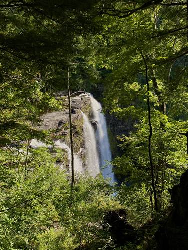
Salmon River Falls Overlook - Mile 0.05
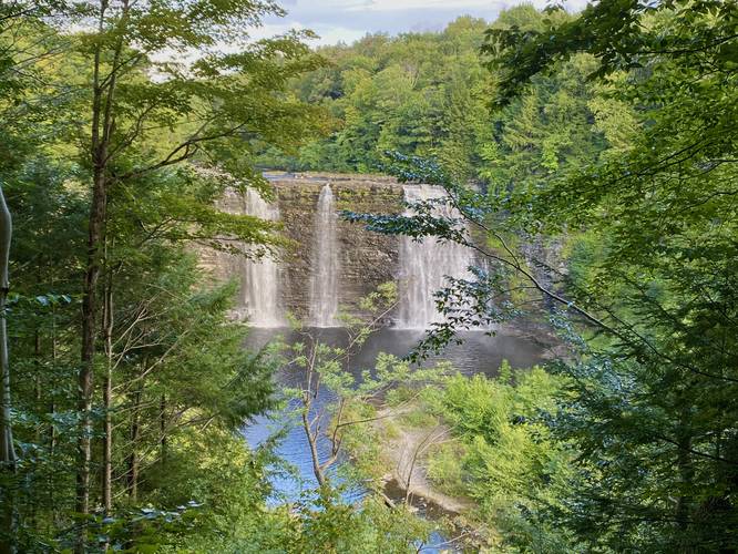
Hikers will find a quick view of Salmon River Falls almost immediately, located near the trailhead. This is one of the best views of the waterfall, despite the obstruction from the trees, because you get the see the entire waterfall without hiking the super-steep and somewhat sketchy Salmon River Falls Gorge Trail.
The trail will continue onward from the first overlook area, passing the Salmon River Falls Gorge Trail along the way.
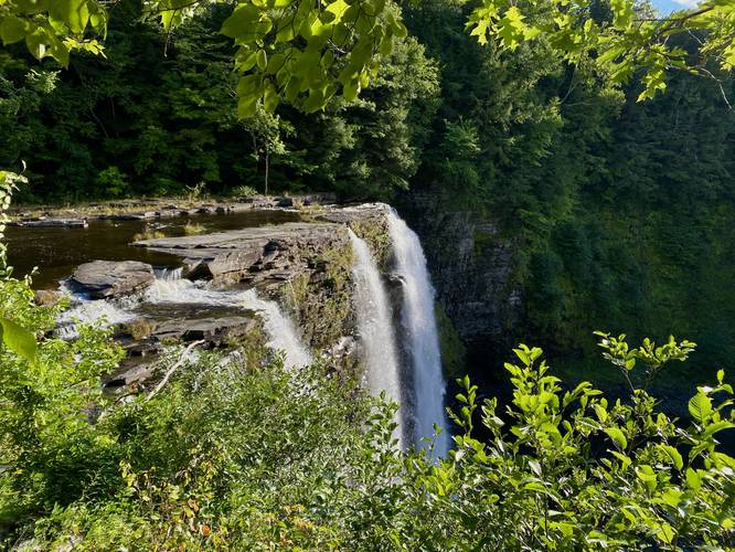
Top of Salmon River Falls Overlook - Mile 0.2
Around mile 0.2, the trail will reach another overlook of Salmon River Falls, but this time it's located adjacent to the top of the waterfall. From here, hikers get a close-up view of the 110-foot tall waterfall.
Riverside Hike - Mile 0.22 to 0.32
From mile 0.22 to 0.32 (out-and-back) hikers can take a series of stairs that lead to the creek and out to the top of Salmon River Falls. Note that there's a line/marker where visitors should not pass to ensure their own safety.
From here, the hike is "over" unless you wish to hike upstream further. The walk back to the parking lot is about 0.25-miles from the top of the waterfall, hence the 0.5-mile out-and-back hike. If you're adventurous and don't mind a sketchy hike, be sure to check out the Salmon River Falls Gorge Trail before you leave - it's super hard and a bit sketchy, but the views from the bottom are awesome. Most hikers skip that trail as well, so there's far less people down in the gorge than on this accessible trail.
Parking
Hikers will find plenty of parking at the large parking lot at the coordinates provided along Falls Road.
Pets
Dogs are allowed only if leashed and must be cleaned up after.
Warning
Steep ledges: This hike includes several areas where you can walk up to 110-foot tall ledges. Watch your step and stay back from ledges to enjoy the views.
Universal Access
Note that this trail is mostly universally accessible. Visitors will find a wide, flat, and crushed stone pathway that leads to two viewing areas of Salmon River Falls - all fully accessible; however, this GPS track leads down a series of stairs that leads to the creek bed and top of Salmon River Falls, which is not universally accessible.
Hike Description
This hike begins at the main parking lot and trailhead for Salmon River Falls and heads in along the universal access trail.
Salmon River Falls Overlook - Mile 0.05
Hikers will find a quick view of Salmon River Falls almost immediately, located near the trailhead. This is one of the best views of the waterfall, despite the obstruction from the trees, because you get the see the entire waterfall without hiking the super-steep and somewhat sketchy Salmon River Falls Gorge Trail.
The trail will continue onward from the first overlook area, passing the Salmon River Falls Gorge Trail along the way.
Top of Salmon River Falls Overlook - Mile 0.2
Around mile 0.2, the trail will reach another overlook of Salmon River Falls, but this time it's located adjacent to the top of the waterfall. From here, hikers get a close-up view of the 110-foot tall waterfall.
Riverside Hike - Mile 0.22 to 0.32
From mile 0.22 to 0.32 (out-and-back) hikers can take a series of stairs that lead to the creek and out to the top of Salmon River Falls. Note that there's a line/marker where visitors should not pass to ensure their own safety.
From here, the hike is "over" unless you wish to hike upstream further. The walk back to the parking lot is about 0.25-miles from the top of the waterfall, hence the 0.5-mile out-and-back hike. If you're adventurous and don't mind a sketchy hike, be sure to check out the Salmon River Falls Gorge Trail before you leave - it's super hard and a bit sketchy, but the views from the bottom are awesome. Most hikers skip that trail as well, so there's far less people down in the gorge than on this accessible trail.
Parking
Hikers will find plenty of parking at the large parking lot at the coordinates provided along Falls Road.
Pets
Dogs are allowed only if leashed and must be cleaned up after.
Warning
Steep ledges: This hike includes several areas where you can walk up to 110-foot tall ledges. Watch your step and stay back from ledges to enjoy the views.