Salmon River Falls Gorge Trail at Salmon River Falls Unique Area near Orwell, New York is a strenuous and very steep trail that leads to the base of the 110-foot tall Salmon River Falls.
Hike Description
This trail is only for the very physically-fit and adventurous hiker that doesn't mind super-steep grades and a bit of a sketchy downhill hike. This trail begins along the universally-accessible Salmon River Falls Trail, not far from that trail's trailhead, and leads down the super-steep gorge. The trail includes many rock steps along the way but there's only one section that has a helpful handrail - most of the trail does not provide any handrails or handholds aside from scrambling down or back up the trail.
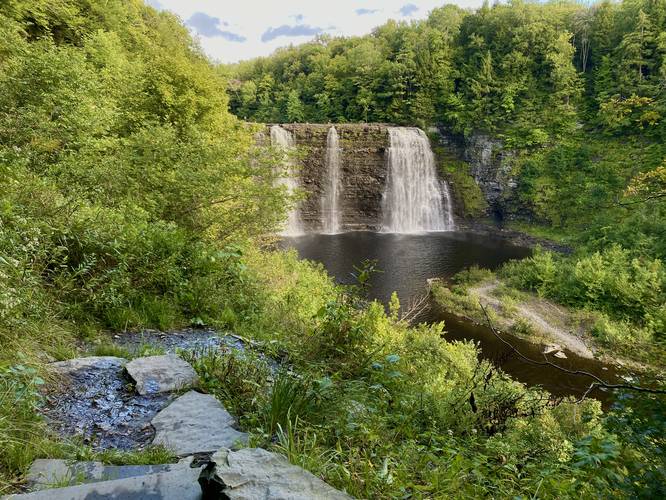
Salmon River Falls View - Mile 0.05
Just down the rock ledge from the trailhead, around mile 0.05, is a stunning view of Salmon River Falls from the switchback in the trail.
After the first switchback, the trail then heads down another set of super-steep rock steps to continue the descent toward the bottom of the gorge. Once near the bottom of the gorge, the trail meanders its way out toward Salmon River Falls as it weaves in and around plants and shrubs while traversing over a very rocky surface.
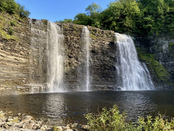
Salmon River Falls - Mile 0.15
Around mile 0.15, hikers will reach the base of Salmon River Falls as it cascades over the bedrock ledge at ~110-feet high. The waterfall creates a mist that permeates the air and is a nice feeling on a hot Summer day.
Hiking Out - Mile 0.15 to 0.3
The hike out of Salmon River Falls Gorge is much harder than it looks as most of the trail just heads straight up the gorge's canyon walls. Take your time and enjoy the slow climb out as you slowly scramble up the rock steps.
Parking
Hikers will find a large parking lot at the coordinates provided for Salmon River Falls Unique Area along Falls Road.
Pets
Dogs are allowed only if leashed and must be cleaned up after.
Warnings
Super steep terrain: This trail follows really steep terrain that most people are not comfortable hiking down or back up. Do not attempt this trail if you do not feel comfortable.
Ledges: This trail passes ledges with drop-offs and while most of them are not very tall, you would not want to fall off of any of them as they could cause serious injury or worse.
Poison ivy: This trail passes through some patches of poison ivy.
Winter Exploring
This trail is closed to all visitors in the Winter except for ice climbers with experience. Ice climbers must sign-in and out using the ice climbing registry form at the trailhead.
Hike Description
This trail is only for the very physically-fit and adventurous hiker that doesn't mind super-steep grades and a bit of a sketchy downhill hike. This trail begins along the universally-accessible Salmon River Falls Trail, not far from that trail's trailhead, and leads down the super-steep gorge. The trail includes many rock steps along the way but there's only one section that has a helpful handrail - most of the trail does not provide any handrails or handholds aside from scrambling down or back up the trail.
Salmon River Falls View - Mile 0.05
Just down the rock ledge from the trailhead, around mile 0.05, is a stunning view of Salmon River Falls from the switchback in the trail.
After the first switchback, the trail then heads down another set of super-steep rock steps to continue the descent toward the bottom of the gorge. Once near the bottom of the gorge, the trail meanders its way out toward Salmon River Falls as it weaves in and around plants and shrubs while traversing over a very rocky surface.
Salmon River Falls - Mile 0.15
Around mile 0.15, hikers will reach the base of Salmon River Falls as it cascades over the bedrock ledge at ~110-feet high. The waterfall creates a mist that permeates the air and is a nice feeling on a hot Summer day.
Hiking Out - Mile 0.15 to 0.3
The hike out of Salmon River Falls Gorge is much harder than it looks as most of the trail just heads straight up the gorge's canyon walls. Take your time and enjoy the slow climb out as you slowly scramble up the rock steps.
Parking
Hikers will find a large parking lot at the coordinates provided for Salmon River Falls Unique Area along Falls Road.
Pets
Dogs are allowed only if leashed and must be cleaned up after.
Warnings
Super steep terrain: This trail follows really steep terrain that most people are not comfortable hiking down or back up. Do not attempt this trail if you do not feel comfortable.
Ledges: This trail passes ledges with drop-offs and while most of them are not very tall, you would not want to fall off of any of them as they could cause serious injury or worse.
Poison ivy: This trail passes through some patches of poison ivy.
Winter Exploring
This trail is closed to all visitors in the Winter except for ice climbers with experience. Ice climbers must sign-in and out using the ice climbing registry form at the trailhead.