Loading...

WINTER SALE! 50% OFF Supporter Accounts — now through January 31st. Learn More.

Robertson Mountain Hike

Overlooking Old Rag Mountain, the Robertson Mountain hike has one of the steepest trails in the central section of the Shenandoah National Park, with an elevation gain on the Robertson Mountain Trail of 1,700 feet in just over 1.5 miles. Directly to the west of Old Rag you have excellent views of the mountain, while avoiding all the crowds that flock there. Two sections of this circuit take advantage of fire roads which some may find boring, but after the tough climb up Robertson Mountain it can be a nice reprieve.

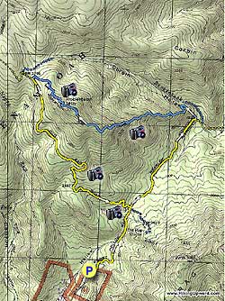
From the parking area, pass the closed gate hiking up the yellow blazed Berry Hollow Fire Road for 0.8 miles. Here you reach the intersection of the Old Rag Fire Road on the left, the Saddle Trail on the right, and Weakley Hollow Fire Road that continues straight.

Continue straight on the yellow blazed Weakley Hollow Fire Road (concrete post points towards Old Rag Parking Area) for 1.2 miles and arrive at the Robertson Mountain Trail.

Turn left uphill on the blue blazed Robertson Mountain Trail for the steepest section of the loop, and gain 1,700ft in just over 1.5 miles to the top of Robertson Mountain.

Continue down the other side of Robertson Mountain on the Robertson Mountain Trail where it ends at the junction of the Old Rag Fire Road in another 0.6 miles.

Turn left downhill on the yellow blazed Old Rag Fire Road as it descends for 2.2 miles back to the intersection with the Berry Hollow Fire Road.

Turn right on the Berry Hollow Fire Road for the remaining 0.8 miles back to the parking area.

Explore 86 trails near Oldrag, VA

Know Before You Go

  • The Robertson Mountain hike offers excellent views of Old Rag Mountain without the crowds.
  • The 7.2-mile hike is strenuous, featuring a very steep climb of 1,700 feet in 1.5 miles on the Robertson Mountain Trail.
  • The loop trail includes sections on fire roads which provide a less challenging respite from the steep climb.
Interactive topographic map for Robertson Mountain Hike located in Oldrag, VA. Click the "View Map" button to load GPS coordinates and trail markers.
Get directions
Distance
7.2 mi
Difficulty
Hard
Type
Loop
Est. Time
3.6 hrs
Elev. Gain
2,193'
Rating
3.8
Added
March 19, 2025
Updated
April 06, 2025

Weather Forecast

Loading...
Total Change
1,733'
Ascent
2,193'
Descent
2,195'
Loading...

Download the GPX Data for Offline Use

Supporters get exclusive access to download trail routes to the MyHikes app for offline use. Stay prepared on your adventure, even without an internet connection! Become a Supporter today to unlock this feature and hike with confidence.

Download Robertson Mountain Hike GPX Data to the MyHikes Mobile App

Features

Vista / Lookout Point
Dogs
Mountain Summit
Camping
Water Source

Points of interest

  1. Parking

    38.548649, -78.338849
  2. Main Trailhead

    38.54877, -78.338807

Safety information

For your own safety: plan ahead, let someone know where you'll be, and hike at your own risk.

Hazards

Snakes (Rattlesnakes, Copperheads, others)
Poison Ivy or Poison Oak

Availability

All seasons

Surface type

Dirt

Trip Reports (Reviews)

Rated 3.79 out of 5 based on 42 ratings.

Ready to help fellow hikers? Add a trip report to share your experience and provide valuable insights for other hikers!

By: Steve
7.2 miles / 11.6 km
October 14, 2019
I hiked this as described. I found the fire roads a nice break from the rocky hikes I am usually on, and from the steep trail here. If you are going to hike a steep trail, this is the one to do it on. The trail is rocky but well maintained. There are many rocks and downed trees alongside the trail on which to sit and catch your breath. It's not explicit in the description but there is a short (200 feet or so) side trail to the left (following the suggested route) at the top. It passes a campsite which was in use and ends at a great overlook from which you can see Old Rag and Hawksbill Peak. The parking lot holds about 15 vehicles -- there were five when I arrived at 8 a.m. and it was filled when I returned in the early afternoon. The description says this hike is 6.8 miles but I carried a couple of GPS devices that showed closer to eight miles.
Legacy Review
By: Emily
7.2 miles / 11.6 km
August 04, 2018
My husband, daughter, Australian Sheppard and I did this hike today, as a second choice when we learned that dogs can't hike Old Rag. It was a great adventure! We took the Corbin trail on the way back to the fire trail, which was a good way to change it up. The rain over the last week was very heavy, which made the river (creek?) crossings challenging, but still fun! And parts of the trail we were actually hiking in ankle-deep water. We all had a blast! And calculated that we hiked almost 9 miles today! For a 7-year-old, that's pretty awesome!
Legacy Review
By: O'Mals
7.2 miles / 11.6 km
December 21, 2016
This is a great hike. Easy approach on the fire road. Great views through the bare trees along the ascent. Excellent panorama at the summit. Took Corbin Hollow on the way back to mix things up. My only complaint is the $20 parking fee at the Old Rag parking lot, and that's really my own fault for not getting a pass! The hike might not be as popular as its neighbors, but fewer people make for a more enjoyable day.
Legacy Review
No community routes found. To add your own hike as a Community Route for this Trail guide, leave a Trip Report with an attached GPX file.

Popular categories

Scenic mountain view representing vista trails
Vista trails
Scenic gorge of cascades representing waterfall trails
Waterfall hikes
Rugged mountain terrain representing summit trails
Summit trails
Scenic mountain view representing dog-friendly trails
Dog-friendly
Scenic campsite with a view representing camping trails
Camping trails
Appalachian Trail logo representing A.T. hikes
A.T. hikes

You May Also Like

25 Best Day Hikes in North Carolina - Discover the top 25 best day hikes in North Carolina, from breathtaking waterfalls to mountain peaks. Explore hidden gems, scenic views, and trails suitable for all skill levels, perfect for your next outdoor adventure.
Explore

25 Best Day Hikes in North Carolina

Discover the top 25 best day hikes in North Carolina, from breathtaking waterfalls to mountain peaks. Explore hidden gems, scenic views, and trails suitable for all skill levels, perfect for your next outdoor adventure.

Read
🍪 We use cookies to learn about site usage and to serve map tiles. You may block cookies manually in the browser. By continuing you agree. Learn more