Loading...

WINTER SALE! 50% OFF Supporter Accounts — now through January 31st. Learn More.

Roaring Fork Falls Hike

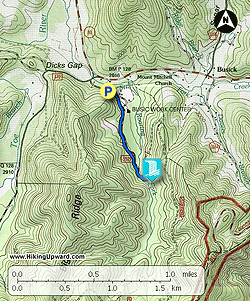
If you are in the South Toe River Valley, then consider a quick detour to the beautiful Roaring Fork Falls. Located just off NC-80 this waterfall is accessed via an easy 1.5-mile hike. From NC-80 turn left onto South Toe River Road towards the Black Mountain Campground and take an immediate left on Busick Work Center Road after a bridge over Still Fork Creek. At the end of the road is a small parking area before a gated compound, the Roaring Fork Falls Trail follows a gravel road to the waterfall. This waterfall is not tall but makes up for it with a beautiful setting as the creek pours through a narrow, green chasm over many small cascades. Pictures do not do justice the steepness and power of this amazing waterfall.

  • Mile 0.0 – Hike begins at the parking area for the Roaring Fork Trail. The trail is a flat, gravel road to the waterfall. You will see Roaring Fork below the left side of the trail.
  • Mile 0.6 – The trail branches to the right before a bridge leaving the gravel road.
  • Mile 0.7 – Reach the base of Roaring Fork Falls. Roaring Fork flows through a tall, narrow chute with many small cascades totaling over 50 feet high. You can get very close to the lowest cascade of the waterfall. Do not attempt to scramble high up the falls because most of the rocks are wet, sloped, and covered in slick moss.  
  • Mile 1.3 – Hike ends back at the parking lot.
By HikingUpward Contributor: Zach Robbins
Explore 37 trails near Burnsville, NC

Know Before You Go

  • Roaring Fork Falls is an easily accessible waterfall near Burnsville, NC, featuring a relatively flat, gravel trail of 1.3 miles roundtrip.
  • The waterfall isn't very tall but is known for its scenic beauty, cascading through a narrow, green chasm with multiple small cascades.
  • Caution is advised against climbing on the rocks near the falls due to their steepness, wetness, and moss coverage.
Interactive topographic map for Roaring Fork Falls Hike located in Burnsville, NC. Click the "View Map" button to load GPS coordinates and trail markers.
Get directions
Distance
1.3 mi
Difficulty
Easy
Type
Out-and-Back
Est. Time
39 min
Elev. Gain
155'
Rating
4.5
Added
March 13, 2025
Updated
April 05, 2025

Weather Forecast

Loading...
Total Change
111'
Ascent
155'
Descent
155'
Loading...

Download the GPX Data for Offline Use

Supporters get exclusive access to download trail routes to the MyHikes app for offline use. Stay prepared on your adventure, even without an internet connection! Become a Supporter today to unlock this feature and hike with confidence.

Download Roaring Fork Falls Hike GPX Data to the MyHikes Mobile App

Features

Waterfalls
Water Source

Points of interest

  1. Parking

    35.768468, -82.195304
  2. Main Trailhead

    35.768468, -82.195304

Safety information

For your own safety: plan ahead, let someone know where you'll be, and hike at your own risk.

Hazards

Snakes (Rattlesnakes, Copperheads, others)
Poison Ivy or Poison Oak

Availability

All seasons

Surface type

Dirt

Trip Reports (Reviews)

Rated 4.5 out of 5 based on 2 ratings.

Ready to help fellow hikers? Add a trip report to share your experience and provide valuable insights for other hikers!

By: Morgan M.
1.3 miles / 2.1 km
April 05, 2019
An easy, flat hike to a gorgeous waterfall. Isolated - saw only footprints of one other person. Great for any age.
Legacy Review
By: Ryan
1.3 miles / 2.1 km
December 31, 2016
This is a great hike with very little elevation change that is good for smaller children. A good video overview of the hike can be found here: https://www.hdcarolina.com/episode/roaring-fork-falls There are also a lot of other things to see in this area. You could easily spend a while day exploring this area.
Legacy Review
No community routes found. To add your own hike as a Community Route for this Trail guide, leave a Trip Report with an attached GPX file.

Popular categories

Scenic mountain view representing vista trails
Vista trails
Scenic gorge of cascades representing waterfall trails
Waterfall hikes
Rugged mountain terrain representing summit trails
Summit trails
Scenic mountain view representing dog-friendly trails
Dog-friendly
Scenic campsite with a view representing camping trails
Camping trails
Appalachian Trail logo representing A.T. hikes
A.T. hikes

You May Also Like

25 Best Day Hikes in North Carolina - Discover the top 25 best day hikes in North Carolina, from breathtaking waterfalls to mountain peaks. Explore hidden gems, scenic views, and trails suitable for all skill levels, perfect for your next outdoor adventure.
Explore

25 Best Day Hikes in North Carolina

Discover the top 25 best day hikes in North Carolina, from breathtaking waterfalls to mountain peaks. Explore hidden gems, scenic views, and trails suitable for all skill levels, perfect for your next outdoor adventure.

Read
Colorado's Million Dollar Highway - Plan a day's drive adventure along the iconic Million Dollar Highway in Colorado. Explore the best short trails, roadside stops, waterfalls, vistas, ghost towns, and hot springs within a ~6 hour road trip.
Explore

Colorado's Million Dollar Highway

Plan a day's drive adventure along the iconic Million Dollar Highway in Colorado. Explore the best short trails, roadside stops, waterfalls, vistas, ghost towns, and hot springs within a ~6 hour road trip.

Read
Glacier's Going-to-the-Sun Road - Discover the breathtaking beauty of Glacier National Park along the iconic Going-to-the-Sun Road. From stunning roadside stops to picturesque waterfalls and vistas, this engineering marvel offers endless opportunities for exploration.
Explore

Glacier's Going-to-the-Sun Road

Discover the breathtaking beauty of Glacier National Park along the iconic Going-to-the-Sun Road. From stunning roadside stops to picturesque waterfalls and vistas, this engineering marvel offers endless opportunities for exploration.

Read
🍪 We use cookies to learn about site usage and to serve map tiles. You may block cookies manually in the browser. By continuing you agree. Learn more