Loading...

❄️ WINTER SALE! 50% OFF on Supporter Accounts — now through January 31st. Unlock a full year of exclusive website & app perks. Learn More.

Riverbluffs Trail Hike

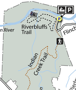
The Riverbluffs Trail is a short, family-friendly hike along the Dan River in Hanging Rock State Park. Situated far away from the main park facilities, the Dan River Access is primarily used by boaters. The Indian Creek Trail and Riverbluffs Trail originate at the access parking area, providing opportunities for a short or longer hike. The Riverbluffs Trail described here takes you along a beautiful stretch of the Dan River with shoals, rapids, and exposed cliffs. If this short hike isn’t enough for you, consider adding the Indian Creek Trail or other trails in the park.

  • Mile 0.0 – The Dan River Access for Hanging Rock State Park is located at the end of Flinchum Rd. To reach the Riverbluffs Trail, follow the Indian Creek Trail (red square blaze) south from the parking area.

  • Mile 0.15 – The Indian Creek Trail crosses a footbridge over Indian Creek and meets the Riverbluffs Trail at a T-junction. Turn right onto the Riverbluffs Trail (red hexagon blaze) and stay left at the loop trail split. The trail meanders through hardwood forests above the floodplain of the Dan River. Occasional forest roads lead to the left away from the trail.

  • Mile 0.7 – Make a wide right turn towards the river. An old forest road continues straight into a field.

  • Mile 0.8 – The Riverbluffs Trail meets the Dan River at a sandy shoreline. The river fans out upstream through pebble shoals. The trail parallels the Dan River for the next 0.6-mi.

  • Mile 1.0 – Beginning of the river bluffs section. On the opposite side of the trail, large exposed cliffs rise high above the river downstream for hundreds of yards. Since the river narrows through this section, it is not safe to swim when the water is up.

  • Mile 1.45 – The trail turns right away from the river.

  • Mile 1.6 – The loop ends, turn left crossing the Indian Creek footbridge.

  • Mile 1.7 – Hike ends at the Dan River Access.

By HikingUpward Contributor: Zach Robbins
Explore 6 trails near Danbury, NC

Know Before You Go

  • The Riverbluffs Trail is a 1.4-mile, family-friendly hike along the Dan River, accessible through the Dan River Access point of Hanging Rock State Park.
  • The trail features diverse scenery including hardwood forests, a sandy shoreline along the Dan River, shoals, rapids and exposed cliffs.
  • The Riverbluffs Trail connects with the Indian Creek Trail, allowing hikers to extend their trip for a longer hike within Hanging Rock State Park.
Interactive topographic map for Riverbluffs Trail Hike located in Danbury, NC. Click the "View Map" button to load GPS coordinates and trail markers.
Get directions
Distance
1.4 mi
Difficulty
Easy
Type
Loop
Est. Time
42 min
Elev. Gain
46'
Rating
0.0
Added
April 02, 2025
Updated
April 06, 2025

Weather Forecast

Loading...
Total Change
48'
Ascent
46'
Descent
47'
Loading...

Download the GPX Data for Offline Use

Supporters get exclusive access to download trail routes to the MyHikes app for offline use. Stay prepared on your adventure, even without an internet connection! Become a Supporter today to unlock this feature and hike with confidence.

Download Riverbluffs Trail Hike GPX Data to the MyHikes Mobile App

Features

Vista / Lookout Point
Dogs
Water Source

Points of interest

  1. Parking

    36.429788, -80.248347
  2. Main Trailhead

    36.429535, -80.248454

Safety information

For your own safety: plan ahead, let someone know where you'll be, and hike at your own risk.

Hazards

Snakes (Rattlesnakes, Copperheads, others)
Poison Ivy or Poison Oak

Markers

Blaze Color

Red

Availability

All seasons

Surface type

Dirt

Trip Reports (Reviews)

Your opinion matters! Be the first to rate this trail.

Ready to help fellow hikers? Add a trip report to share your experience and provide valuable insights for other hikers!

No community routes found. To add your own hike as a Community Route for this Trail guide, leave a Trip Report with an attached GPX file.

Popular categories

Scenic mountain view representing vista trails
Vista trails
Scenic gorge of cascades representing waterfall trails
Waterfall hikes
Rugged mountain terrain representing summit trails
Summit trails
Scenic mountain view representing dog-friendly trails
Dog-friendly
Scenic campsite with a view representing camping trails
Camping trails
Appalachian Trail logo representing A.T. hikes
A.T. hikes

You May Also Like

25 Best Day Hikes in North Carolina - Discover the top 25 best day hikes in North Carolina, from breathtaking waterfalls to mountain peaks. Explore hidden gems, scenic views, and trails suitable for all skill levels, perfect for your next outdoor adventure.
Explore

25 Best Day Hikes in North Carolina

Discover the top 25 best day hikes in North Carolina, from breathtaking waterfalls to mountain peaks. Explore hidden gems, scenic views, and trails suitable for all skill levels, perfect for your next outdoor adventure.

Read
Colorado's Million Dollar Highway - Plan a day's drive adventure along the iconic Million Dollar Highway in Colorado. Explore the best short trails, roadside stops, waterfalls, vistas, ghost towns, and hot springs within a ~6 hour road trip.
Explore

Colorado's Million Dollar Highway

Plan a day's drive adventure along the iconic Million Dollar Highway in Colorado. Explore the best short trails, roadside stops, waterfalls, vistas, ghost towns, and hot springs within a ~6 hour road trip.

Read
Glacier's Going-to-the-Sun Road - Discover the breathtaking beauty of Glacier National Park along the iconic Going-to-the-Sun Road. From stunning roadside stops to picturesque waterfalls and vistas, this engineering marvel offers endless opportunities for exploration.
Explore

Glacier's Going-to-the-Sun Road

Discover the breathtaking beauty of Glacier National Park along the iconic Going-to-the-Sun Road. From stunning roadside stops to picturesque waterfalls and vistas, this engineering marvel offers endless opportunities for exploration.

Read
🍪 We use cookies to learn about site usage and to serve map tiles. You may block cookies manually in the browser. By continuing you agree. Learn more