Loading...

🎁 Holiday Gifts Alert! Get 30% off the artist's markup on all landscape prints with code HXJBJU to support MyHikes! Browse prints.

Riggenberg Castle Ruins

Directions
Map
Pictures
Send to App
Distance:
0.2 km / 0.1 Miles
Type:
Out-and-Back
Difficulty:
Easy
Time to Hike:
~15 minutes
Features:
Surface Type:
Dirt
Town:
Ringgenberg, Switzerland
Get Directions:
46.700587, 7.895485
Added:
September 15, 2025
Updated:
October 25, 2025
Copy Trail Link Hiking this trail? Send a friend or family member a link to this trail guide for your own safety. Hike at your own risk (disclaimer)
Loading...
Loading...
7m

Total Change
13m

Ascent
13m

Descent

Download the Trail Route for Offline Use

Supporters get exclusive access to download trail routes to the MyHikes app for offline use. Stay prepared on your adventure, even without an internet connection! Become a Supporter today to unlock this feature and hike with confidence.

Send to App

Key Takeaways

  • 13th-century Swiss history and stunning views over Lake Brienz.
  • Short, accessible walk from parking to castle ruins with panoramic views.
  • Explore noble court culture, a destroyed fortress, and the historic Burgkirche (castle church).

Riggenberg Castle Ruins

On the southwest corner of Brienzersee (Lake Brienz), located in Riggenberg, Switzerland, sits the Riggenberg Castle Ruins that date back to the 13th century.

This short and easy walk leads visitors from the parking area through the castle ruins to reach beautiful views of Lake Brienz where you’ll find a bit of local history from the castle that was originally constructed around 1300.

Explore the Riggenberg Castle Ruins

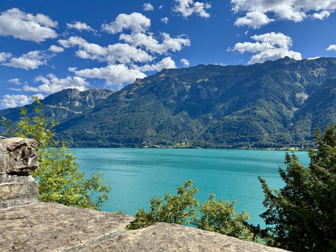
Starting at the small parking area along Burgliweg, visitors will walk down the road to reach the front steps to the Riggenberg Castle Ruins. As you climb the stairs, the castle ruins begin to appear as you pass beautiful views of Lake Brienz’ turquoise waters and surrounding mountains.

Located on the side of the Burgkirche (castle church), you may notice a very old sundial that was once used to tell the time. These days, the sundial reads the wrong time, but you can imagine how important that technology was back in the day.

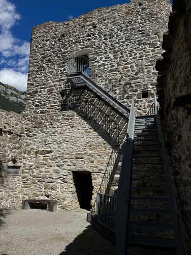
After passing the Burgkirche, the path leads north to reach the Riggenberg Castle Ruins where visitors can climb a metal staircase that leads to the top of the castle tower ruins. Follow the suspended metal grate around the top of the tower ruins to enjoy views from the top! From the tower ruins, visitors will find more views of Lake Brienz and its stunning turquoise hues. While there isn’t much to see in the castle ruins today, you can imagine how the towering stone walls and tower were once seen as a protecting fortress and place for nobility to congregate.

Parking

Visitors will find a very small parking lot along Burgliweg located on the north side of the road. The parking lot is a paid parking lot based on an hourly rate and is large enough to fit about 5 vehicles or less as of September 2025.

History

Translated from some of the signage at the castle ruins: The prominent location on Lake Brienz highlights the Riggenberg Castle ruins as an important site in Bernese history. As the ancestral seat of the influential Imperial Bailiffs of Brienz, the later Lords of Riggenberg, the castle held political weight in the region since the mid-13th century. Under the minstrel Johannes von Riggenberg, the castle rose to become a center of the courtly culture for the high nobility around 1300.

After the castle was destroyed in the “Riggenberg Trade” in 1381, the site lost its imporance as a focal point of the landscape and was abandoned. The ruins subsequently fell into disrepair several times. With the construction of the church in 1670 - 1671, the complex acquired a new function, but only the renovations in 1928, 1946/1949, and most recently in 2006/2008 halted its decline.

The castle was renovated for the first time in 1928. Since then, it has been under federal protection. Further maintenance work followed in 1946/1949. In 2006, the poor condition of the masonry made further renovations necessary. Strict attention was paid to preserving the existing structure. The walls were cleaned and archaeologically examined, cracks and joints were freshly mortared. The tops of the new walls were given a new layer of masonry as a weatherproof layer. Since the last renovation, a steel staircase has once again led up to the old high entrance of the tower. A gallery has been built at the level of the former ballroom, with a viewing terrace overlooking the lake above.

Explore 11 trails near Ringgenberg, Switzerland
  1. Parking

    46.700587, 7.895485
  2. Main Trailhead

    46.700607, 7.896017
  3. View of Lake Brienz from RIggenberg Castle

    46.700886, 7.896819
    View of Lake Brienz from RIggenberg Castle
  4. Riggenberg Castle tower

    46.701022, 7.897031
    Riggenberg Castle tower
No community routes found. To add your own hike as a Community Route for this Trail guide, leave a Trip Report with an attached GPX file.

Seasons

All

Photo Albums

+ Add Photo Album

Upload your photos from the trail to help others know what to expect.

Preview of the MyHikes mobile app interface

Track, Log, and Explore Hikes with the MyHikes App

Shop Landscape Prints
Shop our Alps landscape prints to support MyHikes!

Trip Reports (Reviews)

Ready to help fellow hikers? Add a trip report to share your experience and provide valuable insights for those planning their next hike. Your review makes the trail better for everyone.

Rated 4.0 out of 5 based on 1 rating.
0.1 miles / 0.2 km
September 15, 2025
Nice views of the lake and interesting castle ruins.
Hiking

Explore Hiking Trails

You May Also Like

Colorado's Million Dollar Highway - Plan a day's drive adventure along the iconic Million Dollar Highway in Colorado. Explore the best short trails, roadside stops, waterfalls, vistas, ghost towns, and hot springs within a ~6 hour road trip.
Explore

Colorado's Million Dollar Highway

Plan a day's drive adventure along the iconic Million Dollar Highway in Colorado. Explore the best short trails, roadside stops, waterfalls, vistas, ghost towns, and hot springs within a ~6 hour road trip.

Read
Glacier's Going-to-the-Sun Road - Discover the breathtaking beauty of Glacier National Park along the iconic Going-to-the-Sun Road. From stunning roadside stops to picturesque waterfalls and vistas, this engineering marvel offers endless opportunities for exploration.
Explore

Glacier's Going-to-the-Sun Road

Discover the breathtaking beauty of Glacier National Park along the iconic Going-to-the-Sun Road. From stunning roadside stops to picturesque waterfalls and vistas, this engineering marvel offers endless opportunities for exploration.

Read
New York's Best Waterfalls - Whether you're planning a day hike, roadside stop, or a leisurely short walk, this guide provides hikers, travelers, and locals alike with 63 different locations to over 100 scenic waterfalls to help plan your next adventure!
Explore

New York's Best Waterfalls

Whether you're planning a day hike, roadside stop, or a leisurely short walk, this guide provides hikers, travelers, and locals alike with 63 different locations to over 100 scenic waterfalls to help plan your next adventure!

Read

Before you boogie...

Find our trail guides useful? Consider becoming a Supporter to unlock perks!

MyHikes is an indie platform that makes exploring public trails easier for everyone. The platform has no investors, no ads, and is owned and operated by one person, Dave Miller. Dave has personally mapped and written over 1,800 trail guides on MyHikes for the public to explore. MyHikes has helped millions outdoor enthusiasts plan their next adventure.

But it takes a lot of time 🕦, money 💰, work, and espresso shots ☕ to run MyHikes, including hiking , mapping , writing , and publishing new trails with high-quality (accurate) information... along with software engineering (coding) the platform like building new features, website and mobile app development (iOS and Android), site maintainance . and much much more.

Supporters unlock website and mobile app perks with an annual one-time payment of $25 (you renew) 😎👍. Or you can simply make a Donation of your choice. Otherwise, you can support us by telling your friends about MyHikes - both quick and free 🎉

Admin avatar

Dave Miller
MyHikes Founder
🍪 We use cookies to learn about site usage, performance, and to serve map tiles. You may block cookies manually in the browser. By continuing to use MyHikes, you agree. Learn more