The Red Ledge Scramble at Tioga State Forest near Wellsboro, Pennsylvania is a strenuous and dangerous 4.3-mile out-and-back ascent that leads up a small portion of the PA Grand Canyon's Red Ledge Ridge. This hike was an attempt to uncover a long-lost forestry trail that used to climb Red Ledge Ridge; however, hikers should note that this trail no longer exists and this track provided - following deer and bear trails up the mountain - is extremely dangerous due to the mountain's super steep elevation grade in an area with no cell service. This location was posted to show hikers what does exist here, but does not exist as a challenge to the public. This mountain ascent is no joke and should be taken with all precautions and seriousness if actually attempting to make it to the top of Red Ledge Ridge. Alternatively, this is a very easy and very safe out-and-back walk with nice views of Pine Creek and a seasonal waterfall - for hikers looking to enjoy a peaceful walk along the creek instead.
Trails
This hike follows one named trail: Pine Creek Trail.
Hike Description
This track begins at the public access to Tiadaghton Village near Wellsboro, PA and follows the Pine Creek Trail heading south. Along the way, hikers will pass a long stretch of private land before reaching Red Ledge.
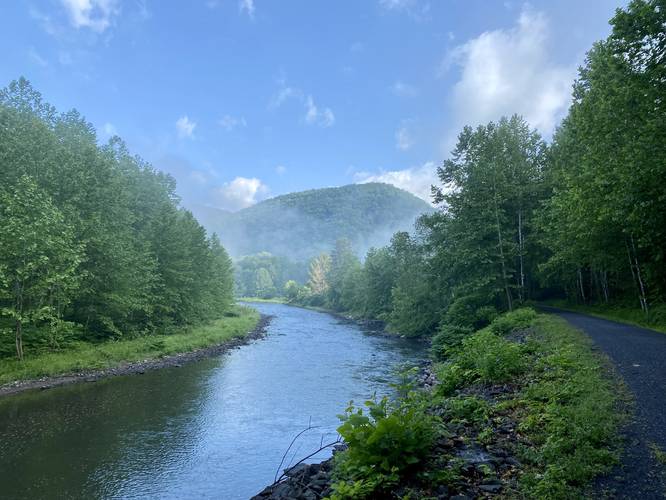
Pine Creek & Canyon Mountain View - Mile 0.65
Around mile 0.65, hikers will reach a clearing above Pine Creek that provides a beautiful view of the creek and canyon mountains that surround Tiadaghton village.
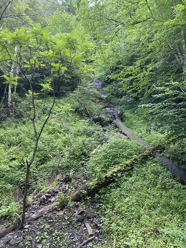
Red Ledge Falls (private land) - Mile 1.55
Around mile 1.55, and during early Spring (when snow is melting off of the mountains), hikers will find a large waterfall, approximately 30-feet tall, named Red Ledge Falls. When the water is flowing, it cascades over a sheer rock face with a vertical drop down into the canyon where the water then flows directly into Pine Creek. This waterfall is located on private property, so please do not trespass, but it can be viewed from the Pine Creek Trail.
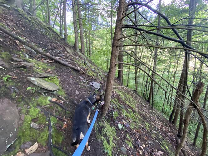
Red Ledge Climb - Mile 1.85
At mile 1.85, hikers will reach a small turnout along the Pine Creek Trail where, as of June 2022, there's a small bench and a bike rack. Across the trail, to the east, a keen-eyed hiker may be able to spot a deer trail heading up the mountain. This is the climbing route that I followed. Upon my first (and so far, only) visit here, I assumed this path was the same, or very close to, the old forestry trail that used to lead up to Red Ledge Ridge. Once on the trail, I noticed that it disappeared fairly quickly and had to improvise. I hiked up the mountain heading due-north and located another deer/bear trail that wrapped its way around the western side of the mountain. This path is very skinny and it showed signs of droppings, claw marks in the mud, and rocks overturned - clear signs of black bear. Eventually, the trail follows a switchback and heads up an even-steeper section of mountain. Here, the mountain's slopes become steeper, which appeared angled over 50-degrees, making this part of the hike terrifying, especially with a dog that kept pulling me up and sliding down the mountain. Like idiots, Jax and I continued the ascent - passing a well-established tree with roots for "steps" and then made it ~30-feet above that tree before deciding the elevation grade - becoming even more steep - was far too dangerous to continue the climb. I decided to head back and went as slow as possible - mostly sitting on my butt as I scooted down the mountain back to the "flatter" switchback area. Hikers should be warned that this steep mountain ascent is no joke - it appears to be a lot worse than PA Half Dome, and more dangerous.
Warnings
Rattlesnakes: This area is home to the Timber Rattlesnake. If bushwhacking up Red Ledge (not recommended), then your chances of encountering a rattler are significantly higher. Give them space and be on the lookout on and off-trail.
Steep elevation grade / death grade: Once the hiker is ascending Red Ledge, the mountain becomes extremely steep just after 150 vertical feet - and so much so that I did this write-up to warn folks about this climb and to steer people away from it. You do not want to accidentally slip down this mountain because you may not make it home.
Private property: Note that this hike follows a large swath of private property located just off-trail to the east of the Pine Creek Trail. Even in some sections of designated Pine Creek Gorge Natural Area tracts of land, some of those sections are actually privately-owned. Please respect land owners and stay on the trail unless you plan to adventure off-trail on public land only.
No cell service: There is no cell phone service along this hike due to the deep canyon terrain.
Trails
This hike follows one named trail: Pine Creek Trail.
Hike Description
This track begins at the public access to Tiadaghton Village near Wellsboro, PA and follows the Pine Creek Trail heading south. Along the way, hikers will pass a long stretch of private land before reaching Red Ledge.
Pine Creek & Canyon Mountain View - Mile 0.65
Around mile 0.65, hikers will reach a clearing above Pine Creek that provides a beautiful view of the creek and canyon mountains that surround Tiadaghton village.
Red Ledge Falls (private land) - Mile 1.55
Around mile 1.55, and during early Spring (when snow is melting off of the mountains), hikers will find a large waterfall, approximately 30-feet tall, named Red Ledge Falls. When the water is flowing, it cascades over a sheer rock face with a vertical drop down into the canyon where the water then flows directly into Pine Creek. This waterfall is located on private property, so please do not trespass, but it can be viewed from the Pine Creek Trail.
Red Ledge Climb - Mile 1.85
At mile 1.85, hikers will reach a small turnout along the Pine Creek Trail where, as of June 2022, there's a small bench and a bike rack. Across the trail, to the east, a keen-eyed hiker may be able to spot a deer trail heading up the mountain. This is the climbing route that I followed. Upon my first (and so far, only) visit here, I assumed this path was the same, or very close to, the old forestry trail that used to lead up to Red Ledge Ridge. Once on the trail, I noticed that it disappeared fairly quickly and had to improvise. I hiked up the mountain heading due-north and located another deer/bear trail that wrapped its way around the western side of the mountain. This path is very skinny and it showed signs of droppings, claw marks in the mud, and rocks overturned - clear signs of black bear. Eventually, the trail follows a switchback and heads up an even-steeper section of mountain. Here, the mountain's slopes become steeper, which appeared angled over 50-degrees, making this part of the hike terrifying, especially with a dog that kept pulling me up and sliding down the mountain. Like idiots, Jax and I continued the ascent - passing a well-established tree with roots for "steps" and then made it ~30-feet above that tree before deciding the elevation grade - becoming even more steep - was far too dangerous to continue the climb. I decided to head back and went as slow as possible - mostly sitting on my butt as I scooted down the mountain back to the "flatter" switchback area. Hikers should be warned that this steep mountain ascent is no joke - it appears to be a lot worse than PA Half Dome, and more dangerous.
Warnings
Rattlesnakes: This area is home to the Timber Rattlesnake. If bushwhacking up Red Ledge (not recommended), then your chances of encountering a rattler are significantly higher. Give them space and be on the lookout on and off-trail.
Steep elevation grade / death grade: Once the hiker is ascending Red Ledge, the mountain becomes extremely steep just after 150 vertical feet - and so much so that I did this write-up to warn folks about this climb and to steer people away from it. You do not want to accidentally slip down this mountain because you may not make it home.
Private property: Note that this hike follows a large swath of private property located just off-trail to the east of the Pine Creek Trail. Even in some sections of designated Pine Creek Gorge Natural Area tracts of land, some of those sections are actually privately-owned. Please respect land owners and stay on the trail unless you plan to adventure off-trail on public land only.
No cell service: There is no cell phone service along this hike due to the deep canyon terrain.