Loading...

❄️ WINTER SALE! 50% OFF on Supporter Accounts — now through January 31st. Unlock a full year of exclusive website & app perks. Learn More.

Raven Rock Hike

Raven Rock is the namesake landmark of Raven Rock State Park in the Piedmont region of North Carolina. The park sits along the fall zone between the Piedmont and the Coastal Plain, less than an hour south of the Triangle. This fall zone gives rise to geological oddities highlighted by Raven Rock and Cliffs of the Neuse State Parks. The most popular trail in the park and one of the most popular hikes near the Triangle leads to the cliff base of Raven Rock and an overlook 150 feet above the Cape Fear River. These chalky white cliffs at times rise 100 feet, an awe-inspiring scene this far east of the Blue Ridge Mountains. You won’t find cliffs like this until you reach the Kings Mountain range near Charlotte or the Sauratown Mountains near Winston-Salem. In addition to exploring the cliff base, the overlook has nice views upriver of the Fish Traps rapids and Northington Ferry. At 2.7 miles, this is a relatively short hike that can be completed in under 90 minutes. If you would like to hike more, consider the Campbell Creek Loop Trail on the west side of the park.

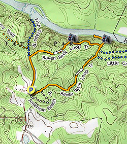
  • Mile 0.0 – The Raven Rock Loop Trail begins on either side of the parking lot. Follow the Raven Rock Loop Trail (orange circle blaze) east past the wooden fence and immediately pass a T-junction with the American Beech Trail (white circle blaze).
  • Mile 0.15 – Restroom and picnic facilities are located off to the left of the trail.
  • Mile 0.2 – T-junction with the American Beech Trail on the right.
  • Mile 0.25 – Y-junction with a gated forest road on the left. You’ll pass through thicker pine and hickory/oak forests as you enter the Little Creek watershed.
  • Mile 0.5 – First wooden bridge over Little Creek.
  • Mile 0.65 – Second wooden bridge over Little Creek.
  • Mile 0.75 – Third wooden bridge over Little Creek. Immediately after the crossing is a Y-junction with the Little Creek Loop Trail (blue hexagon trail) on the right. The Little Creek Loop Trail is the only access to the backcountry group campsite.
  • Mile 0.9 – T-junction with the Little Creek Loop Trail on the right.
  • Mile 0.95 – T-junction with the descent trail to Raven Rock. Continue straight and soon you will descend 135 steps to the base of Raven Rock.
  • Mile 1.0 – The steps end at the base of Raven Rock close to the shore of the Cape Fear River. On the right the trail peters out below a massive cliff. A tree leans over the river providing a nice viewpoint.
  • Mile 1.1 – Back at the base of the stairs the trail heads west following the cliff base. Immediately the trail passes under a massive overhang. The chalky white cliffs of Raven Rock rise above the Cape Fear River for hundreds of yards and at times are nearly 100 feet high. These are arguably the most impressive cliffs east of the Sauratown Mountains. There are multiple paths down here below the cliffs, some heading to viewpoints along the water and some sticking close to the cliffs.
  • Mile 1.3 – The path ends where the cliffs meet the water, it is impossible to continue from here without getting into the river.
  • Mile 1.5 – Turn right on the Raven Rock Loop Trail following the crest of Raven Rock. There are no views from the trail on this quarter-mile stretch.
  • Mile 1.8 – The Raven Rock Overlook is located off to the right of the trail. This stone observation perch rises more than 150 feet above the Cape Fear River. Looking upstream you should be able to see the Fish Traps rapids and Northington Ferry.
  • Mile 2.3 – T-junction with the Fish Traps Trail (blue triangle blaze) on the right. The Fish Traps Trail is also the connection for the Northington Ferry Trail.
  • Mile 2.5 – Hike ends at the parking area.
By HikingUpward Contributor: Zach Robbins
Explore 1 trail near Lillington, NC

Know Before You Go

  • Raven Rock Trail is a 2.5-mile loop in Raven Rock State Park, Lillington, NC, featuring unique chalky white cliffs and views of the Cape Fear River.
  • The trail leads to both the base of Raven Rock along the Cape Fear River and an overlook 150 feet above, offering views of Fish Traps rapids and Northington Ferry.
  • The hike includes varied terrain, such as bridges over Little Creek, a descent via 135 steps to the cliff base, and a walk along the crest of Raven Rock, suitable for completion in under 90 minutes.
Interactive topographic map for Raven Rock Hike located in Lillington, NC. Click the "View Map" button to load GPS coordinates and trail markers.
Get directions
Distance
2.5 mi
Difficulty
Easy
Type
Loop
Est. Time
1.3 hrs
Elev. Gain
343'
Rating
4.0
Added
April 02, 2025
Updated
April 06, 2025

Weather Forecast

Loading...
Total Change
224'
Ascent
343'
Descent
345'
Loading...

Download the GPX Data for Offline Use

Supporters get exclusive access to download trail routes to the MyHikes app for offline use. Stay prepared on your adventure, even without an internet connection! Become a Supporter today to unlock this feature and hike with confidence.

Download Raven Rock Hike GPX Data to the MyHikes Mobile App

Features

Vista / Lookout Point
Dogs
Water Source

Points of interest

  1. Parking

    35.461959, -78.911829
  2. Main Trailhead

    35.461959, -78.911829

Safety information

For your own safety: plan ahead, let someone know where you'll be, and hike at your own risk.

Hazards

Snakes (Rattlesnakes, Copperheads, others)
Poison Ivy or Poison Oak

Markers

Blaze Color

Orange

Availability

All seasons

Surface type

Dirt

Trip Reports (Reviews)

Rated 4.0 out of 5 based on 1 rating.

Ready to help fellow hikers? Add a trip report to share your experience and provide valuable insights for other hikers!

By: Zachary Robbins
2.5 miles / 4.0 km
August 31, 2019
I took my mom on this hike, very manageable for people in their 60s in average shape. Even though all parking lots were crowded we actually did not see many people on the loop. Maybe there was an event in another area of the park, or most people were hiking to Lanier Falls to swim. The cool thing about Raven Rock is even in the middle of summer, there is a significant cooling effect at the base since it faces north, is overhanging, and is beside the river. I would estimate it was at least 10F cooler at the base of Raven Rock compared to the trails up top.
Legacy Review
No community routes found. To add your own hike as a Community Route for this Trail guide, leave a Trip Report with an attached GPX file.

Popular categories

Scenic mountain view representing vista trails
Vista trails
Scenic gorge of cascades representing waterfall trails
Waterfall hikes
Rugged mountain terrain representing summit trails
Summit trails
Scenic mountain view representing dog-friendly trails
Dog-friendly
Scenic campsite with a view representing camping trails
Camping trails
Appalachian Trail logo representing A.T. hikes
A.T. hikes

You May Also Like

25 Best Day Hikes in North Carolina - Discover the top 25 best day hikes in North Carolina, from breathtaking waterfalls to mountain peaks. Explore hidden gems, scenic views, and trails suitable for all skill levels, perfect for your next outdoor adventure.
Explore

25 Best Day Hikes in North Carolina

Discover the top 25 best day hikes in North Carolina, from breathtaking waterfalls to mountain peaks. Explore hidden gems, scenic views, and trails suitable for all skill levels, perfect for your next outdoor adventure.

Read
Colorado's Million Dollar Highway - Plan a day's drive adventure along the iconic Million Dollar Highway in Colorado. Explore the best short trails, roadside stops, waterfalls, vistas, ghost towns, and hot springs within a ~6 hour road trip.
Explore

Colorado's Million Dollar Highway

Plan a day's drive adventure along the iconic Million Dollar Highway in Colorado. Explore the best short trails, roadside stops, waterfalls, vistas, ghost towns, and hot springs within a ~6 hour road trip.

Read
Glacier's Going-to-the-Sun Road - Discover the breathtaking beauty of Glacier National Park along the iconic Going-to-the-Sun Road. From stunning roadside stops to picturesque waterfalls and vistas, this engineering marvel offers endless opportunities for exploration.
Explore

Glacier's Going-to-the-Sun Road

Discover the breathtaking beauty of Glacier National Park along the iconic Going-to-the-Sun Road. From stunning roadside stops to picturesque waterfalls and vistas, this engineering marvel offers endless opportunities for exploration.

Read
🍪 We use cookies to learn about site usage and to serve map tiles. You may block cookies manually in the browser. By continuing you agree. Learn more