Loading...

🎉 Enjoy a Free 7-Day Supporter Trial and Unlock Exclusive Perks — No Credit Card Required. Learn more.

Many Habitats Trail

Directions
Map
Pictures
Send to App
Distance:
0.6 Miles / 1.0 km
Type:
One-Way
Difficulty:
Easy
Time to Hike:
~18 minutes
Features:
Surface Type:
Dirt
Park:
Boyce Mayview Park
Town:
Upper Saint Clair, Pennsylvania
Directions:
40.317817, -80.109218
Added:
April 26, 2021
Updated:
April 26, 2021
Copy Trail Link Hiking this trail? Send a friend or family member a link to this trail guide for your own safety. Hike at your own risk (disclaimer)
Loading...
Loading...
60'

Total Change
107'

Ascent
69'

Descent

Download the Trail Route for Offline Use

Supporters get exclusive access to download trail routes to the MyHikes app for offline use. Stay prepared on your adventure, even without an internet connection! Become a Supporter today to unlock this feature and hike with confidence.

Send to App

Many Habitats Trail

The Many Habitats Trail at Boyce Mayview Park in Upper Saint Clair, Pennsylvania is an easy 0.6-mile one-way trail that features Spring-time wildflowers, a couple of different environments like woodlands and open fields, and an old abandoned Spring House.

Hike Description
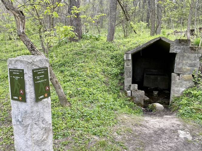
This track begins near the southern terminus along the Falling Leaf Trail and heads north. The trail heads north, entering a large open field for a short distance, before heading back into the woods. The trail passes a pipeline and sections of Spring-time wildflowers before reaching the Spring House Trail, around mile 0.3.

After visiting the old Spring House remains, the trail continues north, passing through a nice section of pine trees before ending at the Queen Maple Trail.

Pets
Dogs are allowed on this trail.

Parking
Hikers will find parking at the coordinates provided along Birds Meadow Drive, right off of Boyce Road in Upper St. Clair. The parking lot is large enough to fit about a dozen vehicles.

Biking
Biking is not allowed along this trail.

Wildflowers
During the Spring (approx. mid-April) this trail usually has some nice wildflowers like Trout Lily and Trillium.

Connecting Trails
This trail connects with the Falling Leaf Trail, Queen Maple Trail, and the Spring House Trail.

Blaze Color
This trail follows wooden posts with Yellow caps on them, hence yellow blazes.
Explore 204 trails near Upper Saint Clair, PA
  1. Parking

    40.317817, -80.109218
  2. Main Trailhead

    40.31696, -80.105435
  3. Abandoned Spring House remains

    40.320117, -80.103333
    Abandoned Spring House remains
No community routes found. To add your own hike as a Community Route for this Trail guide, leave a Trip Report with an attached GPX file.

Hazards

Ticks - Lyme Disease More Info (CDC)
Poison Ivy/Oak

Seasons

All

Blaze Color

Yellow

Trip Reports

Trail Guide By:
Admin user profile picture
0.6 miles / 1.0 km
0.6 miles / 1.0 km
April 24, 2021
Hiking

Weather Forecast

In Upper Saint Clair, PA

Explore Hiking Trails

You May Also Like

Colorado's Million Dollar Highway - Plan a day's drive adventure along the iconic Million Dollar Highway in Colorado. Explore the best short trails, roadside stops, waterfalls, vistas, ghost towns, and hot springs within a ~6 hour road trip.
Explore

Colorado's Million Dollar Highway

Plan a day's drive adventure along the iconic Million Dollar Highway in Colorado. Explore the best short trails, roadside stops, waterfalls, vistas, ghost towns, and hot springs within a ~6 hour road trip.

Read
New York's Best Waterfalls - Whether you're planning a day hike, roadside stop, or a leisurely short walk, this guide provides hikers, travelers, and locals alike with 63 different locations to over 100 scenic waterfalls to help plan your next adventure!
Explore

New York's Best Waterfalls

Whether you're planning a day hike, roadside stop, or a leisurely short walk, this guide provides hikers, travelers, and locals alike with 63 different locations to over 100 scenic waterfalls to help plan your next adventure!

Read

Before you boogie...

Find our trail guides useful? Consider becoming a Supporter to unlock perks!

MyHikes is an indie platform that makes exploring public trails easier for everyone. The platform has no investors, no ads, and is owned and operated by one person, Dave Miller. Dave has personally mapped and written over 1,800 trail guides on MyHikes for the public to explore. MyHikes has helped millions outdoor enthusiasts plan their next adventure.

But it takes a lot of time 🕦, money 💰, work, and espresso shots ☕ to run MyHikes, including hiking , mapping , writing , and publishing new trails with high-quality (accurate) information... along with software engineering (coding) the platform like building new features, website and mobile app development (iOS and Android), site maintainance . and much much more.

Supporters unlock website and mobile app perks with an annual one-time payment of $25 (you renew) 😎👍. Or you can simply make a Donation of your choice. Otherwise, you can support us by telling your friends about MyHikes - both quick and free 🎉

Admin user profile picture

Dave Miller
MyHikes Founder