The Poipu Kai Green Belt in Poipu, Koloa, Hawaii (Kauai) is an easy 1.5-mile out-and-back trail that passes through the Poipu Kai Resort, connecting Poipu Beach to Shipwreck Beach and the Keoneloa Bay Trail.
Hike Description
Hikers will find two trailheads for this trail, but this track begins at the western trailhead located on the corner of Hoone Rd and Pane Rd in Poipu. The trail is paved and should be considered a universal-access trail; however, the eastern trailhead - located along the Keoneloa Bay Trail, is only universally-accessible if starting at the Grand Hyatt Resort and not from the Shipwreck Beach parking lot due to a closed gate at the Grand Hyatt Resort, as of June 2022.
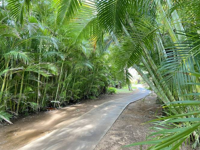
The trail follows a nicely-curated and maintained path that passes flowering plumeria trees, bird of paradise plants, and a "bamboo tunnel" - on the western side of the trail. The eastern side of the path begins right where the bamboo tunnel ends, at the Pe'e Rd crossing. The eastern section of the trail is more open than the western side as it meanders its way through a row of private residences or rental homes within the Poipu Kai Resort itself. Finally, the trail ends where it meets with a junction along the paved section of the Keoneloa Bay Trail, which leads to both the Makahuena Lighthouse and Shipwreck Beach. Hikers can extend their walk by continuing east of Shipwreck Beach to explore Makawehi and the Pa'a Dunes, which provides hikers with stunning views of southern coastal Kauai.
Parking
The parking coordinates for this page will bring hikers to the downtown Poipu public parking lots for Poipu Beach, which are large parking lots that both fit a couple dozen vehicles each. Also note that hikers can also park near the eastern trailhead, by heading to the parking coordinates for Shipwreck Beach instead. Note that to reach this trail from Shipwreck Beach, you must first walk along the Keoneloa Bay Trail that passes in front of the Grand Hyatt Resort.
Pets
Dogs are allowed on this trail and their waste must be cleaned up by the walker. Note that dogs are not allowed on the Keoneloa Bay Trail, so if you plan to bring your dog, pleas respect county park rules and avoid bringing them beyond the eastern trailhead for this trail (i.e. do not park at Shipwreck Beach).
Respecting the Land
Hawaiian land is considered sacred to native Hawaiians and many locals, so please stay on-trail, take nothing but photos, and leave nothing but footprints. Respect the locals - don't stay for long and have a backup hike planned in case the parking lot is full.
Hike Description
Hikers will find two trailheads for this trail, but this track begins at the western trailhead located on the corner of Hoone Rd and Pane Rd in Poipu. The trail is paved and should be considered a universal-access trail; however, the eastern trailhead - located along the Keoneloa Bay Trail, is only universally-accessible if starting at the Grand Hyatt Resort and not from the Shipwreck Beach parking lot due to a closed gate at the Grand Hyatt Resort, as of June 2022.
The trail follows a nicely-curated and maintained path that passes flowering plumeria trees, bird of paradise plants, and a "bamboo tunnel" - on the western side of the trail. The eastern side of the path begins right where the bamboo tunnel ends, at the Pe'e Rd crossing. The eastern section of the trail is more open than the western side as it meanders its way through a row of private residences or rental homes within the Poipu Kai Resort itself. Finally, the trail ends where it meets with a junction along the paved section of the Keoneloa Bay Trail, which leads to both the Makahuena Lighthouse and Shipwreck Beach. Hikers can extend their walk by continuing east of Shipwreck Beach to explore Makawehi and the Pa'a Dunes, which provides hikers with stunning views of southern coastal Kauai.
Parking
The parking coordinates for this page will bring hikers to the downtown Poipu public parking lots for Poipu Beach, which are large parking lots that both fit a couple dozen vehicles each. Also note that hikers can also park near the eastern trailhead, by heading to the parking coordinates for Shipwreck Beach instead. Note that to reach this trail from Shipwreck Beach, you must first walk along the Keoneloa Bay Trail that passes in front of the Grand Hyatt Resort.
Pets
Dogs are allowed on this trail and their waste must be cleaned up by the walker. Note that dogs are not allowed on the Keoneloa Bay Trail, so if you plan to bring your dog, pleas respect county park rules and avoid bringing them beyond the eastern trailhead for this trail (i.e. do not park at Shipwreck Beach).
Respecting the Land
Hawaiian land is considered sacred to native Hawaiians and many locals, so please stay on-trail, take nothing but photos, and leave nothing but footprints. Respect the locals - don't stay for long and have a backup hike planned in case the parking lot is full.