Makawehi & Pa'a Dune Loop in Poipu, Koloa, Hawaii (Kauai) which is part of the Koloa Heritage Trail is a moderate 1.3-mile loop hike that features views from Makawehi Point and the Pa'a Dunes' stunning coastline.
Trails
This hike follows two official trail names: Maha'ulepu Heritage Trail which leads along the coast and ends about 3 miles down the coast around Maha'ulepu Beach and the Koloa Heritage Trail which encompasses several individual trails within Koloa, Hawaii.
Hike Description
This hike begins at the Shipwreck Beach parking lot and immediately heads east - bypassing entering the beach and instead follows the trail that runs within the forest just north (behind) the beach. The trail will eventually hit a split where a steep trail, seemingly heading up Makawehi Point, heads south. Here, stay left and continue up the more gradual ascent to the cliffs.
Makawehi Point Vista - Mile 0.25
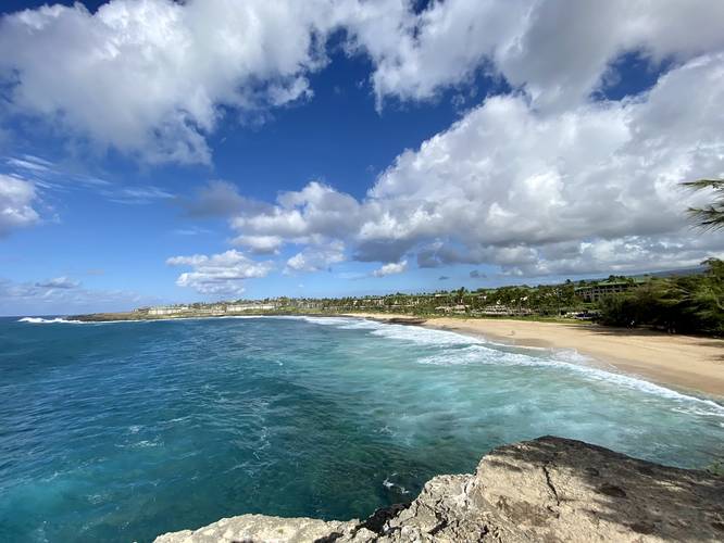
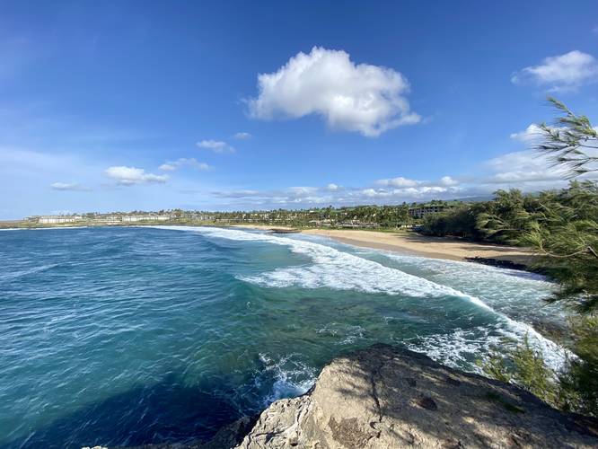
Once on the top of the cliff / Makawehi Bluff, walk southwest toward the end of Makawehi Point which can be found around mile 0.25. The views from Makawehi Point, of Shipwreck Beach and the surrounding resorts, is stunning - the water is extremely clear with a blue-turquoise tint with medium-sized powerful waves that constantly crash ashore or along the bluff itself. Hikers should note that these bluffs have large calving overhangs which will someday fall into the ocean. There's no predicting when sections of these cliffs may giveway, but hikers should not stand near the edge or directly on calving overhangs along these coastal bluffs and cliffs.
Pa'a Dunes and Vistas - Mile 0.4 - 0.8
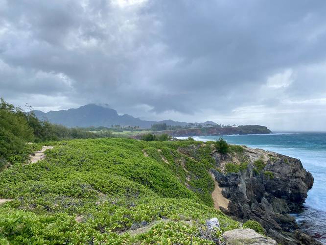
After visiting Makawehi Point, hikers can continue along the cliffs to get more views. If you hike down to the cliffs around mile 0.4, hikers can get an idea of the sea cliff erosion and calving that's happening along these lithified dunes, known as the Pa'a Dunes. As you round the corner of the closest eastern "cove" from Makawehi Point, hikers will notice the rock ledge juts out from over a large cave-like overhang for at least 7-feet or more. You can make your way down into this cave to likely find fossilized creatures or fossilized crab claws - things of that nature; however, I decided to stay above. From here, the trail follows the coastline along, what are at times, sketchy ledges, cliffs, and overhangs - including at least one downhill scramble which is about 5-feet tall. All of which, the hiker is mostly walking through sand, which makes it even more difficult. Along the way, however, are stunning views of the south Kauai mountains along its coastline, which makes for one of the most-beautiful morning walks in southern Kauai, in my opinion.
Hike Out - Mile 0.8
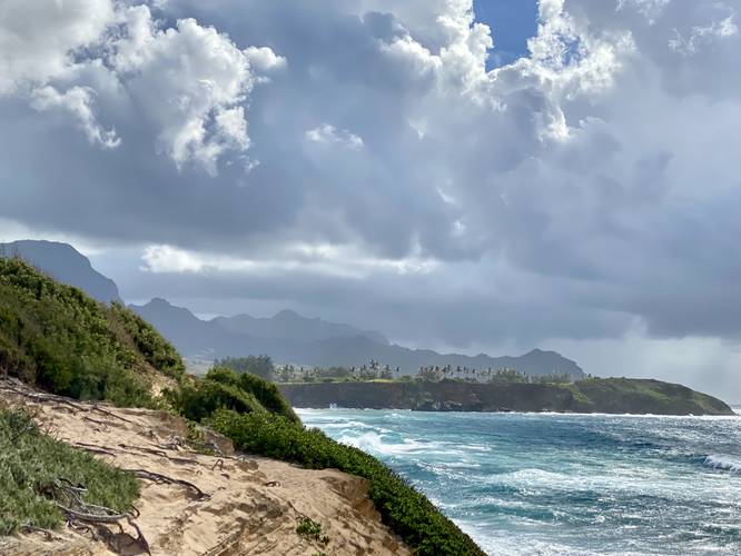
At mile 0.8, I decided to hike back along the same trail (Maha'ulepu Heritage Trail), but further up from the coast, as a rain storm had moved-in overhead. The views from mile 0.8, just before the trail begins to bend northward along the gold course, are some of the best views along this trail - making for a great turnaround point for a short day hike anyway. As the storm moved in, I took cover under the protection of nearby trees and waited for the heavy rains to pass before hiking out. This area is a bit confusing, so using offline maps (openstreetmap is fine) will help aid in your hike here.
Parking
Hikers will find parking at the public parking lot for Shipwreck Beach - at the coordinates provided. If the lot is full, hikers can park in the overflow area located on the public road adjacent to the Grand Hyatt - just north of the parking lot.
Warnings
Cliff undercutting, undermining, calving: Due to the ocean waves constant bombardment, the limestone cliffs of Pa'a Dunes and Makawehi Bluff are slowly eroding. This causes undercutting, undermining, and eventually calving of the bluffs. There's no warning before this happens and due to that, hikers should be aware of what they're walking on. Sometimes you'll hike along the edge of the bluff, but not realize you're walking on a 15-20 foot tall ledge that could, potentially, break away. Be careful and expect the unexpected here, just in case - stay away from the cliff's edge if you can help it or notice undermining of the terrain.
Rock Scrambles: There's at least one rock scramble (covered in sand) located on this hike. It's not easy either way you're headed but the scramble is located near the bluff's edge section of the trail. It can be avoided if you stay on the higher-ground path.
Loose Sand and Steep Terrain: This trail, along the cliff's edge, follows some steep terrain and most of the trail's substrate is sand. It's best to walk slowly and over-evaluate where you're hiking to ensure a safe trip.
Pa'a Dunes History
About 8,000 years ago, sand began depositing atop Makawehi. Over time that sand started a lithification process that turned into limestone. Now, what's leftover is the he Pa'a Dunes - large limestone bluffs that are slowly being eroded away by the ocean, one wave at a time. As stated on the signage on from the Koloa Heritage Trail - The eastern sand dunes of Makawehi, calm face, and Pa'a, hard rock, yield fossilized plant roots, bird bones, crab claws, and other treasures. Prior to extensive wave erosion, this prominent limestone ridge extended across Keoneloa Bay. March through November, water birds visit and sea birds nest and roost in the dunes.
Respecting the Land
Hawaiian land is considered sacred to native Hawaiians and many locals, so please stay on-trail, take nothing but photos, and leave nothing but footprints. Respect the locals - don't stay for long and have a backup hike planned in case the parking lot is full.
Trails
This hike follows two official trail names: Maha'ulepu Heritage Trail which leads along the coast and ends about 3 miles down the coast around Maha'ulepu Beach and the Koloa Heritage Trail which encompasses several individual trails within Koloa, Hawaii.
Hike Description
This hike begins at the Shipwreck Beach parking lot and immediately heads east - bypassing entering the beach and instead follows the trail that runs within the forest just north (behind) the beach. The trail will eventually hit a split where a steep trail, seemingly heading up Makawehi Point, heads south. Here, stay left and continue up the more gradual ascent to the cliffs.
Makawehi Point Vista - Mile 0.25
Once on the top of the cliff / Makawehi Bluff, walk southwest toward the end of Makawehi Point which can be found around mile 0.25. The views from Makawehi Point, of Shipwreck Beach and the surrounding resorts, is stunning - the water is extremely clear with a blue-turquoise tint with medium-sized powerful waves that constantly crash ashore or along the bluff itself. Hikers should note that these bluffs have large calving overhangs which will someday fall into the ocean. There's no predicting when sections of these cliffs may giveway, but hikers should not stand near the edge or directly on calving overhangs along these coastal bluffs and cliffs.
Pa'a Dunes and Vistas - Mile 0.4 - 0.8
After visiting Makawehi Point, hikers can continue along the cliffs to get more views. If you hike down to the cliffs around mile 0.4, hikers can get an idea of the sea cliff erosion and calving that's happening along these lithified dunes, known as the Pa'a Dunes. As you round the corner of the closest eastern "cove" from Makawehi Point, hikers will notice the rock ledge juts out from over a large cave-like overhang for at least 7-feet or more. You can make your way down into this cave to likely find fossilized creatures or fossilized crab claws - things of that nature; however, I decided to stay above. From here, the trail follows the coastline along, what are at times, sketchy ledges, cliffs, and overhangs - including at least one downhill scramble which is about 5-feet tall. All of which, the hiker is mostly walking through sand, which makes it even more difficult. Along the way, however, are stunning views of the south Kauai mountains along its coastline, which makes for one of the most-beautiful morning walks in southern Kauai, in my opinion.
Hike Out - Mile 0.8
At mile 0.8, I decided to hike back along the same trail (Maha'ulepu Heritage Trail), but further up from the coast, as a rain storm had moved-in overhead. The views from mile 0.8, just before the trail begins to bend northward along the gold course, are some of the best views along this trail - making for a great turnaround point for a short day hike anyway. As the storm moved in, I took cover under the protection of nearby trees and waited for the heavy rains to pass before hiking out. This area is a bit confusing, so using offline maps (openstreetmap is fine) will help aid in your hike here.
Parking
Hikers will find parking at the public parking lot for Shipwreck Beach - at the coordinates provided. If the lot is full, hikers can park in the overflow area located on the public road adjacent to the Grand Hyatt - just north of the parking lot.
Warnings
Cliff undercutting, undermining, calving: Due to the ocean waves constant bombardment, the limestone cliffs of Pa'a Dunes and Makawehi Bluff are slowly eroding. This causes undercutting, undermining, and eventually calving of the bluffs. There's no warning before this happens and due to that, hikers should be aware of what they're walking on. Sometimes you'll hike along the edge of the bluff, but not realize you're walking on a 15-20 foot tall ledge that could, potentially, break away. Be careful and expect the unexpected here, just in case - stay away from the cliff's edge if you can help it or notice undermining of the terrain.
Rock Scrambles: There's at least one rock scramble (covered in sand) located on this hike. It's not easy either way you're headed but the scramble is located near the bluff's edge section of the trail. It can be avoided if you stay on the higher-ground path.
Loose Sand and Steep Terrain: This trail, along the cliff's edge, follows some steep terrain and most of the trail's substrate is sand. It's best to walk slowly and over-evaluate where you're hiking to ensure a safe trip.
Pa'a Dunes History
About 8,000 years ago, sand began depositing atop Makawehi. Over time that sand started a lithification process that turned into limestone. Now, what's leftover is the he Pa'a Dunes - large limestone bluffs that are slowly being eroded away by the ocean, one wave at a time. As stated on the signage on from the Koloa Heritage Trail - The eastern sand dunes of Makawehi, calm face, and Pa'a, hard rock, yield fossilized plant roots, bird bones, crab claws, and other treasures. Prior to extensive wave erosion, this prominent limestone ridge extended across Keoneloa Bay. March through November, water birds visit and sea birds nest and roost in the dunes.
Respecting the Land
Hawaiian land is considered sacred to native Hawaiians and many locals, so please stay on-trail, take nothing but photos, and leave nothing but footprints. Respect the locals - don't stay for long and have a backup hike planned in case the parking lot is full.