Makahuena Lighthouse via Keoneloa Bay Trail in Poipu, Koloa, Hawaii (Kauai) which is part of the Koloa Heritage Trail is an easy 1.8-mile out-and-back hike that features stunning views of Keoneloa Bay including Shipwreck Beach, the Makawehi Dunes, the southern Kauai coastline, and leads to the Makahuena Lighthouse.
Hike Description
Hikers and walkers will find public parking at Shipwreck Beach, which is where this trail begins. The public parking lot is a bit small, so the track begins just north of the lot, where visitors can overflow park.
The path leads along the paved and curated trail by the Grand Hyatt first. Walkers will enjoy views of the tropical decor, cabanas (private rentals-only), swinging benches (which can be used by the general public), and the grandiose pools and architecture including a large people-made waterfall that cascades down both side of the Grand Hyatt's staircase, as they make their way along this section of the trail.
Eventually, the path will split just outside of the Grand Hyatt's boundaries - to the right-hand side is the Poipu Kai Green Belt and to the left is the continuation of the Keoneloa Bay Trail. Stay left at the split to continue hiking toward the Makahuena Lighthouse.
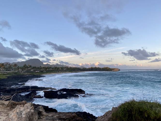
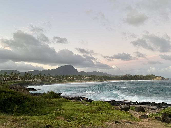
After staying left at the split, hikers will follow a paved path that features even-better views of Keoneloa Bay, Shipwreck Beach, and the Makawehi Dunes (cliffs) in the distance. Watching the ocean from this part of the trail is a nice way to break up the walk and enjoy the scenery. Shortly after, the paved section will end and hikers will be following a red dirt / rocky substrate that leads out to the rocky coast and lighthouse. Note that the trail follows along a large rock wall meant to keep the ocean back in case of storm surges or sneaker waves - hikers should keep their eyes on the ocean to ensure their own safety; however, despite the dangers, hikers will be closer to the crashing / breaking ocean waves on this part of the trail.
Makahuena Lighthouse - Mile 0.9
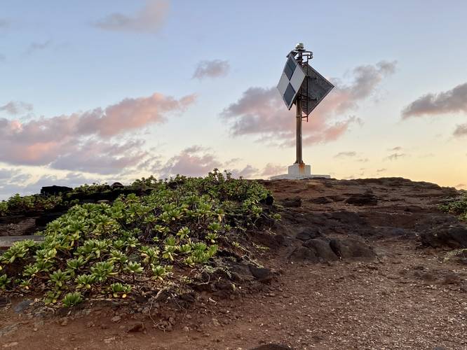
Finally, around mile 0.9, hikers will reach the Makahuena Lighthouse which sits along the rocky southern Kauai coast of Poipu, Koloa, Hawaii. The Lighthouse isn't really much to see - it's a large metal structure that shines a light from its shores during dark hours to ensure ships don't come close. Hikers may notice the "US LHS" concrete block that's sitting on the ground near the lighthouse - this is a "United States Lighthouse Service" marker - potentially used to anchor an old lighthouse that once stood on this concrete block. The US LHS existed from ~1910 to 1939 and they maintained all of the lighthouses for the US government. In 1939, I believe, the US LHS was merged into the US Coast Guard, which is the organization that handles lighthouse maintenance now.
Parking
Hikers and walkers will find parking near the coordinates provided, which leads to the overflow public parking lot for Shipwreck Beach in Koloa, Hawaii (Kauai). You can park in the parking lot if it's available or along the public street adjacent to the Grand Hyatt.
Pets
Dogs are allowed on this trail. If you bring your dog, be respectful of the rules and always keep them on a leash and clean up after your pet.
History
According to the signage for the Koloa Heritage Trail, stone and coral tools found at Keoneloa Bay, or long sand, helped archeologists determine that early Hawaiians used the area between 200 and 600 A.D. as a temporary fishing camp. Later Hawaiians left remnants of heiau, or temples, and ahu, or altars. They prayed to Kane'aukai, an important fishing god.
Respecting the Land
Hawaiian land is considered sacred to native Hawaiians and many locals, so please stay on-trail, take nothing but photos, and leave nothing but footprints. Respect the locals - don't stay for long and have a backup hike planned in case the parking lot is full.
Hike Description
Hikers and walkers will find public parking at Shipwreck Beach, which is where this trail begins. The public parking lot is a bit small, so the track begins just north of the lot, where visitors can overflow park.
The path leads along the paved and curated trail by the Grand Hyatt first. Walkers will enjoy views of the tropical decor, cabanas (private rentals-only), swinging benches (which can be used by the general public), and the grandiose pools and architecture including a large people-made waterfall that cascades down both side of the Grand Hyatt's staircase, as they make their way along this section of the trail.
Eventually, the path will split just outside of the Grand Hyatt's boundaries - to the right-hand side is the Poipu Kai Green Belt and to the left is the continuation of the Keoneloa Bay Trail. Stay left at the split to continue hiking toward the Makahuena Lighthouse.
After staying left at the split, hikers will follow a paved path that features even-better views of Keoneloa Bay, Shipwreck Beach, and the Makawehi Dunes (cliffs) in the distance. Watching the ocean from this part of the trail is a nice way to break up the walk and enjoy the scenery. Shortly after, the paved section will end and hikers will be following a red dirt / rocky substrate that leads out to the rocky coast and lighthouse. Note that the trail follows along a large rock wall meant to keep the ocean back in case of storm surges or sneaker waves - hikers should keep their eyes on the ocean to ensure their own safety; however, despite the dangers, hikers will be closer to the crashing / breaking ocean waves on this part of the trail.
Makahuena Lighthouse - Mile 0.9
Finally, around mile 0.9, hikers will reach the Makahuena Lighthouse which sits along the rocky southern Kauai coast of Poipu, Koloa, Hawaii. The Lighthouse isn't really much to see - it's a large metal structure that shines a light from its shores during dark hours to ensure ships don't come close. Hikers may notice the "US LHS" concrete block that's sitting on the ground near the lighthouse - this is a "United States Lighthouse Service" marker - potentially used to anchor an old lighthouse that once stood on this concrete block. The US LHS existed from ~1910 to 1939 and they maintained all of the lighthouses for the US government. In 1939, I believe, the US LHS was merged into the US Coast Guard, which is the organization that handles lighthouse maintenance now.
Parking
Hikers and walkers will find parking near the coordinates provided, which leads to the overflow public parking lot for Shipwreck Beach in Koloa, Hawaii (Kauai). You can park in the parking lot if it's available or along the public street adjacent to the Grand Hyatt.
Pets
Dogs are allowed on this trail. If you bring your dog, be respectful of the rules and always keep them on a leash and clean up after your pet.
History
According to the signage for the Koloa Heritage Trail, stone and coral tools found at Keoneloa Bay, or long sand, helped archeologists determine that early Hawaiians used the area between 200 and 600 A.D. as a temporary fishing camp. Later Hawaiians left remnants of heiau, or temples, and ahu, or altars. They prayed to Kane'aukai, an important fishing god.
Respecting the Land
Hawaiian land is considered sacred to native Hawaiians and many locals, so please stay on-trail, take nothing but photos, and leave nothing but footprints. Respect the locals - don't stay for long and have a backup hike planned in case the parking lot is full.