Loading...

❄️ WINTER SALE! 50% OFF on Supporter Accounts — now through January 31st. Unlock a full year of exclusive website & app perks. Learn More.

Pilot Mountain Hike

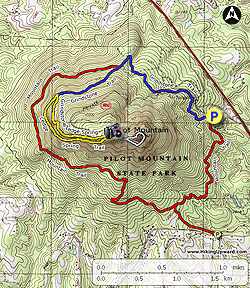
Pilot Mountain is a notable landmark on the Art Loeb Trail in Pisgah National Forest. Its steep, conical summit rises high above the surroundings and can be seen from many viewpoints along the Blue Ridge Parkway and in the Pisgah Ranger District. You can access the peak and make a loop using the Art Loeb Trail and FR 229 from Gloucester Gap on FR 475. Do not be fooled by the short distance, the hike to the 5,095-foot summit climbs over 1,800 feet in 2 miles. Pilot Mountain, the site of a former lookout tower, has open views southeast of Looking Glass Rock and north and west of the Great Balsam Mountains above the Blue Ridge Parkway. The ALT continues north into Deep Gap, where a shelter and spring welcome weekend campers. From Deep Gap you can take FR 229 back to Gloucester Gap or explore deeper into the forest.

  • Mile 0.0 – Follow the Art Loeb Trail [146] (white blaze) north from Gloucester Gap. The ALT climbs switchbacks through open, deciduous forests.

  • Mile 0.4 – Cross FR 229.

  • Mile 0.5 – The ALT crosses FR 229 a second time.

  • Mile 0.7 – Pass by a dry campsite in open woods on the left side of the trail. From here the climb gets tougher as it plows straight uphill using tight switchbacks.

  • Mile 1.0 – On the left side of the trail are rock outcrops with a view west. After this view the trail begins climbing through narrow tunnels of rhododendron, mountain laurel, and rare pinkshell azalea.

  • Mile 1.4 – The ALT passes through a saddle with nice campsites. An overgrown forest road on the right leads down to FR 229.

  • Mile 1.9 – Reach the narrow summit of Pilot Mountain (5,095 feet). From the heath bald you have a good view east of Looking Glass Rock and surrounding plutons, and outstanding views west and north of the Great Balsam Mountains. Beyond the summit the ALT descends moderately (except for the final steep section), towards Deep Gap through sparse forest and pinkshell azalea.

    (You can also shorten this hike by turning around at Pilot Mountain on the ALT, but this very steep descent may be tough on the legs for some hikers.)

  • Mile 2.5 – The Art Loeb Trail passes through Deep Gap below Sassafras Knob. If you continue straight to the left you’ll pass by the Deep Gap Shelter. A water source is close to the shelter. Both Deep Gap and the shelter are excellent for camping. To hike back to Gloucester Gap, make a hard right following FR 229 south.

  • Mile 2.8 – Y-junction with FR 229C on the left.

  • Mile 3.5 – Y-junction with FR 229B on the left. You will likely hear Laurel Fork roaring far below.

  • Mile 4.5 – Hike ends at Gloucester Gap.

By HikingUpward Contributor: Zach Robbins
Explore 16 trails near Brevard, NC

Know Before You Go

  • Pilot Mountain Trail is a challenging 4.5-mile loop near Brevard, NC, featuring a steep 1,800-foot ascent to a summit with panoramic views.
  • The trail utilizes the Art Loeb Trail and FR 229, passing through diverse terrain including deciduous forests, rhododendron tunnels, and heath balds.
  • Deep Gap offers camping options with a shelter and water source, while hikers can shorten the loop by returning from Pilot Mountain summit, though the descent is very steep.
Interactive topographic map for Pilot Mountain Hike located in Brevard, NC. Click the "View Map" button to load GPS coordinates and trail markers.
Get directions
Distance
4.5 mi
Difficulty
Hard
Type
Loop
Est. Time
2.3 hrs
Elev. Gain
1,921'
Rating
4.5
Added
March 13, 2025
Updated
April 05, 2025

Weather Forecast

Loading...
Total Change
1,806'
Ascent
1,921'
Descent
1,921'
Loading...

Download the GPX Data for Offline Use

Supporters get exclusive access to download trail routes to the MyHikes app for offline use. Stay prepared on your adventure, even without an internet connection! Become a Supporter today to unlock this feature and hike with confidence.

Download Pilot Mountain Hike GPX Data to the MyHikes Mobile App

Features

Vista / Lookout Point
Dogs
Mountain Summit
Camping

Points of interest

  1. Parking

    35.265915, -82.846923
  2. Main Trailhead

    35.265915, -82.846923

Safety information

For your own safety: plan ahead, let someone know where you'll be, and hike at your own risk.

Hazards

Snakes (Rattlesnakes, Copperheads, others)
Poison Ivy or Poison Oak

Markers

Blaze Color

White

Availability

All seasons

Surface type

Dirt

Trip Reports (Reviews)

Rated 4.5 out of 5 based on 4 ratings.

Ready to help fellow hikers? Add a trip report to share your experience and provide valuable insights for other hikers!

By: CindyB
4.5 miles / 7.2 km
April 11, 2025
GREAT hike! I chose to modify the route a bit, heading straight up to the summit via the Grindstone Trail first to be sure I had the energy for "strenuous" early in my hike, and then returned back to the Visitor's Center via the Mountain Trail. On a brisk Saturday morning with clear blue skies, the views were awesome and the sunshine was warm. Saw several groups of climbers scaling the cliffs. This hike is already on my "do again" list!
Legacy Review
By: Jim
4.5 miles / 7.2 km
September 09, 2024
Really loved this place and will be going back soon!
Legacy Review
By: Jackie
4.5 miles / 7.2 km
July 13, 2024
Did the full loop as a run the downhills and flats/hike the uphills to fit in a quick hike. I was TIRED after, and it was hot, but it was actually a really fun loop! I messed up and went to the right at the Ledge Spring trail split, and that definitely challenging. Lots of big rock steps, but had fun watching some climbing groups. Coming down I went the Grindstone/Ledge Spring piece and it was much easier and nicer grade!
Legacy Review
No community routes found. To add your own hike as a Community Route for this Trail guide, leave a Trip Report with an attached GPX file.

Popular categories

Scenic mountain view representing vista trails
Vista trails
Scenic gorge of cascades representing waterfall trails
Waterfall hikes
Rugged mountain terrain representing summit trails
Summit trails
Scenic mountain view representing dog-friendly trails
Dog-friendly
Scenic campsite with a view representing camping trails
Camping trails
Appalachian Trail logo representing A.T. hikes
A.T. hikes

You May Also Like

25 Best Day Hikes in North Carolina - Discover the top 25 best day hikes in North Carolina, from breathtaking waterfalls to mountain peaks. Explore hidden gems, scenic views, and trails suitable for all skill levels, perfect for your next outdoor adventure.
Explore

25 Best Day Hikes in North Carolina

Discover the top 25 best day hikes in North Carolina, from breathtaking waterfalls to mountain peaks. Explore hidden gems, scenic views, and trails suitable for all skill levels, perfect for your next outdoor adventure.

Read
Colorado's Million Dollar Highway - Plan a day's drive adventure along the iconic Million Dollar Highway in Colorado. Explore the best short trails, roadside stops, waterfalls, vistas, ghost towns, and hot springs within a ~6 hour road trip.
Explore

Colorado's Million Dollar Highway

Plan a day's drive adventure along the iconic Million Dollar Highway in Colorado. Explore the best short trails, roadside stops, waterfalls, vistas, ghost towns, and hot springs within a ~6 hour road trip.

Read
Glacier's Going-to-the-Sun Road - Discover the breathtaking beauty of Glacier National Park along the iconic Going-to-the-Sun Road. From stunning roadside stops to picturesque waterfalls and vistas, this engineering marvel offers endless opportunities for exploration.
Explore

Glacier's Going-to-the-Sun Road

Discover the breathtaking beauty of Glacier National Park along the iconic Going-to-the-Sun Road. From stunning roadside stops to picturesque waterfalls and vistas, this engineering marvel offers endless opportunities for exploration.

Read
🍪 We use cookies to learn about site usage and to serve map tiles. You may block cookies manually in the browser. By continuing you agree. Learn more